- Home
- :
- All Communities
- :
- Products
- :
- Spatial Data Science
- :
- Spatial Data Science Questions
- :
- Re: Overlapping Polylines to Overlapping Polygons
- Subscribe to RSS Feed
- Mark Topic as New
- Mark Topic as Read
- Float this Topic for Current User
- Bookmark
- Subscribe
- Mute
- Printer Friendly Page
Overlapping Polylines to Overlapping Polygons
- Mark as New
- Bookmark
- Subscribe
- Mute
- Subscribe to RSS Feed
- Permalink
- Report Inappropriate Content
I am writing a script that begins with a polyline feature class. The polylines represent the outlines of images from a flight path, so they are overlapping considerably. I take several steps to convert these image outlines into a single polygon feature class that maintains each image footprint and their overlap.
Here are the steps in my current script:
#Split polyline feature by attributes into separate FCs
#This results in one feature class per polyline feature
arcpy.SplitByAttributes_analysis("Polylines", GDB, "Image")
#Create a list of all polyline FCs
Polyline_List = arcpy.ListFeatureClasses("image*")
#Use a for loop to work with FC list; convert all polylines to polygons
#This results in one feature class per polygon feature
for FC in Polyline_List:
output = FC.replace("image","poly")
arcpy.FeatureToPolygon_management (FC, output)
arcpy.Delete_management(FC)
#Create FC list of all polygons FCs; use list to merge polygons into single FC
Polygon_List = arcpy.ListFeatureClasses("poly*")
arcpy.Merge_management(Polygon_List,"All_Polygons")
#Join Polygon FC to Polyline FC to transfer attribute information
arcpy.AddJoin_management("All_Polygons","OBJECTID","Polylines","OBJECTID")
#Export Polygon FC to make joined data permanent
arcpy.FeatureClassToFeatureClass_conversion("All_polygons",GDB,"Polygons")
I know that there are several custom tools out there that will accomplish this, but I would like to learn how to do this in my own script. Some of my polyline datasets are 350+ images, and exporting out each polyline and then converting each one separately takes forever. There must be an easier way! I'll also add that I used each image's corner coordinates to create the closed polylines. If there is a way to jump right from the corner coordinates to one polygon feature class, that would be even better!
Below is a link to an old thread addressing this problem:
How to convert overlapping polylines to overlapping polygons
Thanks!
- Mark as New
- Bookmark
- Subscribe
- Mute
- Subscribe to RSS Feed
- Permalink
- Report Inappropriate Content
In my original question, I needed a way to process quickly through point data that represented corner coordinates of overlapping images from a flight path. I wanted to create a single polygon feature class containing all of the image "footprints."
I figured this out using geometries and insert cursor. The workflow is much simpler and faster that the original workflow.
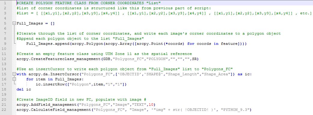
The .py file is also attached