- Home
- :
- All Communities
- :
- Products
- :
- ArcGIS Pro
- :
- ArcGIS Pro Questions
- :
- Re: What is your take on ArcGIS Pro
- Subscribe to RSS Feed
- Mark Topic as New
- Mark Topic as Read
- Float this Topic for Current User
- Bookmark
- Subscribe
- Mute
- Printer Friendly Page
What is your take on ArcGIS Pro
- Mark as New
- Bookmark
- Subscribe
- Mute
- Subscribe to RSS Feed
- Permalink
- Report Inappropriate Content
I have started using ArcGIS Pro for a project looking at Groundwater Vulnerability to Nitrate contamination. I decided that this would be a good project to use to really become acquainted with Pro. I am glad that I am using Pro, I am finding that it is truly much more responsive than using the desktop. Actions that would take upwards of of half hour or more are only taking seconds. I am been able to clip every statewide layer down to the county that I am modeling first. I took me a little bit to get used to the interface, and Esri has been very accommodating to help me get off and running.
There are some quirks with the interface that I would like to see changed or added in time, but all in all I am very impressed. I am wondering what everyone else who is using Pro, what is your opinion of the product? Please give me your true thoughts.
Good job with this products usability.
Chad
- Mark as New
- Bookmark
- Subscribe
- Mute
- Subscribe to RSS Feed
- Permalink
- Report Inappropriate Content
Thank you Tosca.
- Mark as New
- Bookmark
- Subscribe
- Mute
- Subscribe to RSS Feed
- Permalink
- Report Inappropriate Content
More of a question...
I see issues raised, but 'server', 'web', AGOL are often tagged in the same breath.
How much of the performance issues are related to
- the location and storage format of the data? What works with what?
- the access method of the data?
- has the geodatabase (in its incarnations) reached its useful limits for certain types of tasks?
- What benchmarking is there on locally stored and accessed processes versus non-local storage and processing?
- Mark as New
- Bookmark
- Subscribe
- Mute
- Subscribe to RSS Feed
- Permalink
- Report Inappropriate Content
I think what he is referring to is this:
In Arc Cat, I can preview a raster, or any data type, in one monitor, move the mouse pointer around, and either figure out what the coordinate system is just based on the output in the lower right, combined with my local knowledge of what system output what numbers without having to right click on things (in my case it's going to be two possibilities); or, move the mouse around and visualize a few XY's for when I'm in edit mode in Map on another monitor (or another application) and don't want to get out of the tool or GP Tool Input Dialogue I'm using:
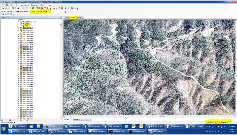
Or I can do this:
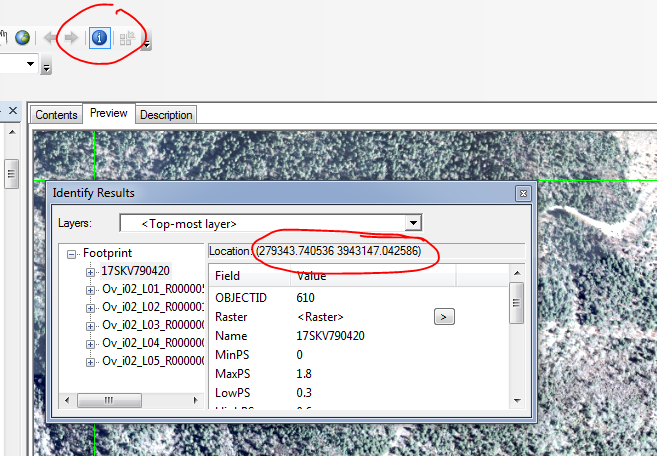
In Pro, how does one do the same thing? Add the same raster to another project in another monitor (which means starting another Pro Project that create another folder, with mode FGDB files)? More steps, when I can just do it in preview in Arc. Based on my last few posts, I'm sure it's another button I've yet to discover...I've been turning things on and off in Project Options, view details, not finding it...tried using the Coordinate Conversion add-in in Pro Catalog View Preview....
- Mark as New
- Bookmark
- Subscribe
- Mute
- Subscribe to RSS Feed
- Permalink
- Report Inappropriate Content
No, Tom, we don't have https://community.esri.com/ideas/13329 It is on the list...
- Mark as New
- Bookmark
- Subscribe
- Mute
- Subscribe to RSS Feed
- Permalink
- Report Inappropriate Content
Slightly related...when I search Ideas that are specifically related to Pro...search results aren't really consistent based on the many many tag permutations that contain the word "Pro" and variations thereof. Time for a Pro "Category" outside of "Desktop"?
- Mark as New
- Bookmark
- Subscribe
- Mute
- Subscribe to RSS Feed
- Permalink
- Report Inappropriate Content
Yeah, its something we've been thinking about. There is a limit to the number of categories we can have so we're trying to figure out the best approach. What is your personal opinion on having a Pro category instead of Desktop, rather than Pro and Desktop?
- Mark as New
- Bookmark
- Subscribe
- Mute
- Subscribe to RSS Feed
- Permalink
- Report Inappropriate Content
I've been using it since January 2018 so about a solid 3 months now. It has it's pros and cons I guess...
Not really seeing how Pro's multi Maps and Layouts in a project is ultimately better than ArcMap's one Map and one Layout MXD setup right now though. Recently wanted to try a common project my company does in Pro to go through the workflow. The project is about a dozen maps all of a project site with different layers on/off. The maps always show the same layers as they are required in a submission packet to state and local government for permits and funding. Just the site location changes.
What I was hoping would be possible is spending time on a single map, pulling in the required data on one Map then creating twelve Layouts and turning the required Layers on/off that I need.
But turning on Layers for one Layout changes them all. So ultimately I need to copy/paste my Map eleven times so each one can be individually tweaked with the right layers then individually linked to each Layout. This is what I do in ArcMap already. Maybe there is some map series function or other tool that could do this that I am not aware of. But until Layouts can freeze out layers in independently, ArcGIS Pro will have to remain a novelty at my company.
- Mark as New
- Bookmark
- Subscribe
- Mute
- Subscribe to RSS Feed
- Permalink
- Report Inappropriate Content
Agree, being able to create several layouts from one map would be fantastic. So much more productive and efficient. A must would also be that each layout could utilise independent definition queries from the same source map.
For me, one of the biggest benefits would be that symbology changes would automatically change for all layouts if they were all fed from one map.
We should check if this has been added to the ideas list and if not it should be added.
- Mark as New
- Bookmark
- Subscribe
- Mute
- Subscribe to RSS Feed
- Permalink
- Report Inappropriate Content
I agree. This is something that other applications can do so I'm really hoping that ESRI incorporates this into Pro at some point in the near future.
- Mark as New
- Bookmark
- Subscribe
- Mute
- Subscribe to RSS Feed
- Permalink
- Report Inappropriate Content
So far, I like the "idea" of Pro. The way it is structured is closer to other GIS and database applications that I have used and I like where it's headed. At this time though, I do find that there are many of the smaller things that are missing. And while I certainly don't mind using different tools to work on a project (my preferred approach really) some of the awkwardness of how Pro works (i.e. forcing you to save/create a project at the outset) make it difficult to fit into our current work flow easily. So for now I keep an eye on it and occasionally use it for simpler projects and use my other tools for the more advanced ones. Glad to see that ESRI is joining my 64bit family of tools though.