- Home
- :
- All Communities
- :
- Products
- :
- ArcGIS Pro
- :
- ArcGIS Pro Questions
- :
- Re: What is your take on ArcGIS Pro
- Subscribe to RSS Feed
- Mark Topic as New
- Mark Topic as Read
- Float this Topic for Current User
- Bookmark
- Subscribe
- Mute
- Printer Friendly Page
What is your take on ArcGIS Pro
- Mark as New
- Bookmark
- Subscribe
- Mute
- Subscribe to RSS Feed
- Permalink
- Report Inappropriate Content
I have started using ArcGIS Pro for a project looking at Groundwater Vulnerability to Nitrate contamination. I decided that this would be a good project to use to really become acquainted with Pro. I am glad that I am using Pro, I am finding that it is truly much more responsive than using the desktop. Actions that would take upwards of of half hour or more are only taking seconds. I am been able to clip every statewide layer down to the county that I am modeling first. I took me a little bit to get used to the interface, and Esri has been very accommodating to help me get off and running.
There are some quirks with the interface that I would like to see changed or added in time, but all in all I am very impressed. I am wondering what everyone else who is using Pro, what is your opinion of the product? Please give me your true thoughts.
Good job with this products usability.
Chad
- Mark as New
- Bookmark
- Subscribe
- Mute
- Subscribe to RSS Feed
- Permalink
- Report Inappropriate Content
Thanks for the feedback, Mark. A lot of good information here and it might take some time to sift through it to make each point actionable. So let me start with something super easy (because it's already done). Have you looked at the most recent comment on Pause Drawing in ArcGIS Pro? It is installed in version 2.2 so you'll see that in this summer's release.
OK, now to the stuff that is going to actually take some time to look into.
I want to get started looking at the big chunk of your response related to drawing cities. I'm downloading the data and maps data right now. You said that you had applied a definition query. Can you share what the query was?
Is performance the same, faster, or slower when a definition query isn't applied?
Let's start with that so we can do some focused work on this issue.
As I look back up through your list, I see your comments about not being able to connect to a root drive. Have you seen https://community.esri.com/ideas/13083 ? We're going to try to get this into an upcoming release - I can't guarantee that it will make it for 2.2, but I wanted to point you to the idea. We watch the ideas site really closely and do a good job updating the statuses, so that is a good way to communicate to us in an actionable way. Anyway, I wanted to make sure you were aware of this as a way to track the status.
Let's start with that. I'll wait for your response on the definition query that you applied and run through what you're reporting in your comment above. As I find time, I'll look into some of the other points you've noted and see if we already have them logged with the appropriate teams.
As you run into things while working with ArcGIS Pro, I'd encourage you to log them directly with technical support so that we can have an analyst dedicate time to the specific issue at hand. If there is something that is less critical, but that you'd like to see in the software, you're still able to log that as an enhancement request through support. And as stated above, you can always search the https://community.esri.com/community/arcgis-ideas?sr=search&searchId=a31c69fe-aa6b-462e-b6ca-06def6a... site to up vote existing ideas or submit ideas of your own and have the community vote. Either of these options - Support or Ideas - provide us with something that holds us accountable for responding to the issue, results in a resolution to the issue or something that is actionable (bug, enhancement request, or idea), and provides you a way of tracking an issue whether through a case number, bug, enh, or idea url.
Thanks again for all of the feedback that you've provided. I look forward to starting to work with you on these.
- Mark as New
- Bookmark
- Subscribe
- Mute
- Subscribe to RSS Feed
- Permalink
- Report Inappropriate Content
If you enter values into fields on a geoprocessing tool, or using the SQL query builder, or customize projection parameters, or etc... and click OK or RUN without either tabbing out of that field or clicking into another field, those values are not used.
I just tried the following in 2.1.2.
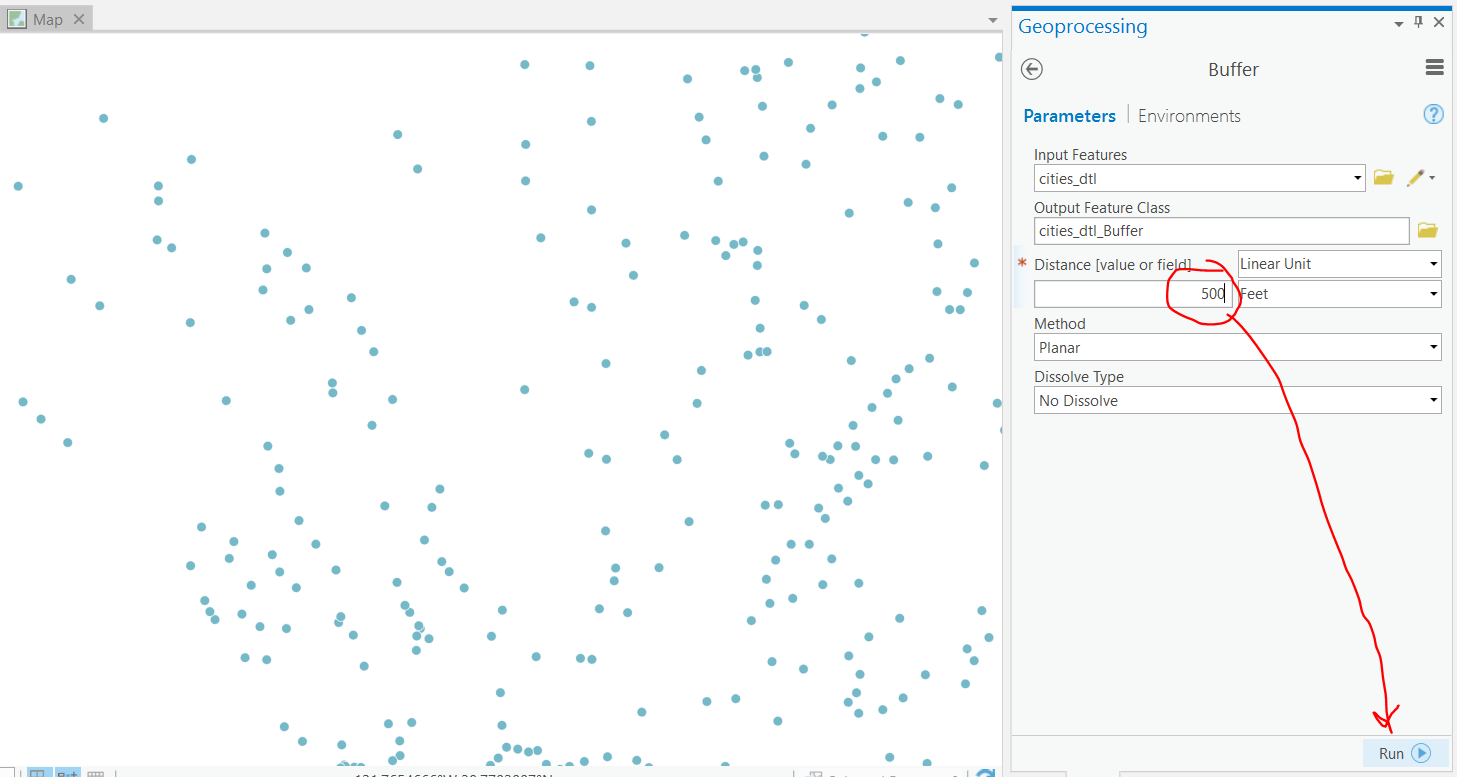
I entered a Distance value of 500 and did not tab out of that cell, then clicked Run.
aviris Could you please provide specific steps to demonstrate the issue?
Thanks!
- Mark as New
- Bookmark
- Subscribe
- Mute
- Subscribe to RSS Feed
- Permalink
- Report Inappropriate Content
Agree Mark.
I have found many of the same issues.
I currently use Pro quite a bit - especially when dealing with ArcGIS Online.
However, when I have to make a large number of maps that not suitable for automation due to client data - there is no way I am going to use Pro. Desktop & Catalog run side by side just gives more productivity on highly variable & small operations. By the time you have had the "beautiful" Pro tool interface render the Desktop process of changing a small thing in symbology or legend has been completed. Found this on many different types of hardware. Would love an option for a more basic interface or disable animations in the interface.
As many are saying - It is getting there but seems Esri don't actually use the products side by side to measure improvements (or not).
For the watching Esri staff :
Summary: Single click GUI operations take longer in Pro than Desktop. Not everyone does long running analysis all day (which in many cases can be faster in Pro).
Who pays for that loss in productivity?
Typical workflow that, if made faster in Pro than Desktop, will win over many more people:
Get shp file from client of proposed bores for new tenement. Also get updated logo.
Open ArcMap:
Open previous MXD of map client likes, check & remove non-required data & sources.
Save copy to a new project folder (using new project codes and file share so to be chinese walled from previous work).
Open Catalog:
Review coordinate system details of supplied data & metadata.
Create new data folder in new location and save shp to new FGDB and reproject to project coordsys. (Let's keep it simple and not play with SDE, SQL, etc).
View latest tenement data and check coordsys & schema (in case the state gov decided to change things up).
View latest open data web services by mining dept. for improved basemaps.
Back in ArcMap:
Update path of tenement layer in MXD to latest.
Change logo to new version
Drag bore layer from Catalog to Map.
Update symbology, layer properties & zoom layering.
Update legend order & add new layer.
Label bores - notice Maplex does not cut it and create annotations from labels.
Edit Annotations.
Drag new basemap label layer to Map from public web service in Catalog.
Update scalebar, graticule/grid, auto text, etc.
Export map to PDF & JPG.
Make sure MXD is saved again.
Next scenario:
Get email from client to change colour of bore dots and add a new background image for another report.
In ArcMap you save the MXD as a new copy with a new Doc Control number. Make the changes and export the map.
You have a clean source of truth for each deliverable you gave the client.
What do you do in Pro? Keep the document control aspects in mind.
Data, Information & Deliverables (maps) are not the same thing and we keep them separate - Pro wants you to jump though hoops to allow you to do this.
This is a very simple exercise but try doing that for a 100 maps where the data or circumstance do not allow for automation and see which tool you will use.
- Mark as New
- Bookmark
- Subscribe
- Mute
- Subscribe to RSS Feed
- Permalink
- Report Inappropriate Content
Hi again aviris I went through the workflow that you describe above and I don't experience the performance lags that you describe. If that is a persistent issue, it would be necessary to log a case with technical support to troubleshoot.
Regarding the UI issue of the symbolized field switching when you change renderers, we've shared that with the map authoring team and they'll take a look at it. For the proportional symbols not displaying as expected in the Contents pane, this is already a known issue that they will be working to address in an upcoming release.
Some of the other items you list are things that we're already aware of and are working to improve. We are interested in the performance issue you describe though and it would be good for you to troubleshoot that specifically with an analyst. Thank you.
- Mark as New
- Bookmark
- Subscribe
- Mute
- Subscribe to RSS Feed
- Permalink
- Report Inappropriate Content
Hi Mark Jackson For the issue you're describing about the World Geocoding Service, are you aware of the ability to create a locator view?
Geocoding and geosearch—ArcGIS Online Help | ArcGIS
By default, ArcGIS Online uses Esri World Geocoding Service to find addresses, cities, landmarks, business names, and postal codes in more than 100 countries around the world. Additionally, Esri World Geocoding Service is used to find the location of x,y coordinates using longitude and latitude, as well as coordinate reference systems such as Military Grid Reference System (MGRS) and United States National Grid (USNG).
If your organization wants to optimize search results for addresses and places of interest, members with privileges to create content can use ArcGIS Online to create a new view of Esri World Geocoding Service to search only for specific types of locations within an area of interest. For example, you might create a locator view to limit search results to a particular country or area or to only return results that match a specific category such as street addresses or airports. Administrators can configure your organization to use your locator view when members perform geosearches.
In ArcGIS Online, you can create a new view of Esri World Geocoding Service to search only for specific types of locations within an area of interest. For example, you may want a locator view to limit search results to particular areas, or you may want to enforce a specific level of precision when members perform batch geocoding of addresses.
So you have the control to configure the service to best meet your organization's needs. And then you can add it to your organization's list of locators available for members to use for geosearch and geocoding.
I hope this helps. Please let us know if you have any questions.
- Mark as New
- Bookmark
- Subscribe
- Mute
- Subscribe to RSS Feed
- Permalink
- Report Inappropriate Content
Kory - thanks very much for this. I wasn't aware of the ability to create a view into the World Geocoding Service.
Please forgive the several subsequent replies - I figured that would be the easiest way to give structured feedback on a number of issues.
- Mark as New
- Bookmark
- Subscribe
- Mute
- Subscribe to RSS Feed
- Permalink
- Report Inappropriate Content
First - following the directions on the page you linked (Create a locator view ) doesn't work.
- Tested creating a view for street addresses using an account with our default user Role (Student - a few more things than Publisher)
- Shared it with our organization
- As Admin, added it to our organization's list of locators
- Signed in to ArcGIS Pro using the account I created the locator with. It shows up in the locators, and allows me to select it to geocode my small list of addresses (21).
- Fails saying I have to have an ArcGIS Online account
- Change to ArcGIS World Geocoding Service (only change) - runs & succeeds fine.
- Restart ArcGIS Pro (just being extra careful) & sign in as our AGOL admin
- Fails saying I have to have an ArcGIS Online account
- Change to ArcGIS World Geocoding Service (only change) - runs & succeeds fine.
- Started all over and created the locator view on ArcGIS Online as the AGOL admin
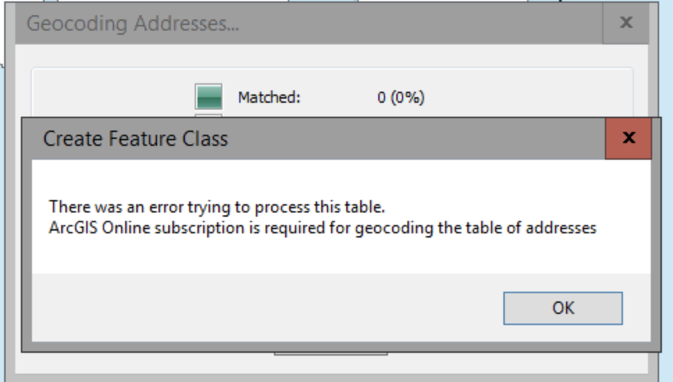
- Same results -- "Error 1545 - ArcGIS Online subscription is required for geocoding the table of addresses"
- Tried in ArcMap (as admin)
- Same results (Pro and ArcMap)
- Changed sharing from Organization to Everyone
- Same results (Pro & ArcMap)
- Deleted them all, and created a view and didn't share it. It isn't automatically added because I didn't add it to our organization, but it is in My Content and I could add it to the project.
- Same error (ArcGIS Pro -- didn't test on ArcMap)
So. Using our custom Student role, the built in Publisher role, and the Admin role it doesn't matter. The view locator's don't work saying you need an ArcGIS Online subscription, but the World Geocoding Service will work in every case immediately after or before on those same accounts.
During this process I also grew to hate the Guided Workflow feature for geocoding addresses. Ideally it would be ask if you ever want to see it again, but at the very least the behavior after the first run through in a session should be reversed, showing the actual tool first with the option to show the guided workflow.
- Mark as New
- Bookmark
- Subscribe
- Mute
- Subscribe to RSS Feed
- Permalink
- Report Inappropriate Content
As a professor who teaches and has watched university faculty and students with very little GIS experience try to perform this "simple" task, but also as an Esri software user for 28+ years, here are some other thoughts. Sorry it is so long, but you seem to actually be interested in the feedback, so I'm attempting to paint an accurate picture for you (not just grousing).
- The help page you linked to is very useful (as usual), but if nobody sees it, it doesn't matter how good it is.
- How does Esri envision people getting to those pages?
- Following the Help link from the Geocode Addresses tool (Geocode Addresses—Help | ArcGIS Desktop ) has none of this information.
- The 2nd bullet point in the Usage section actually states: "Only locators stored in a file folder can be used for geocoding with ArcGIS Pro."
- At the bottom it does mention the World Geocoding Service, but that link also has nothing that would indicate that it is a composite locator by default, let alone any indication that behavior can be changed with custom views
- Use the ArcGIS Online World Geocoding Service—ArcGIS Pro | ArcGIS Desktop for more information.
- "The ArcGIS Online World Geocoding Service allows you to find addresses or places in the world, geocode a table of addresses." sets the expectation that if you give it addresses, it will find addresses.
- Use the ArcGIS Online World Geocoding Service—ArcGIS Pro | ArcGIS Desktop for more information.
- The majority of students, faculty, and myself, use geocoding to geolocate street addresses in a table.
- With the new Geocode Table workflow walkthrough, they feel even better about doing it themselves.
- This is only reinforced by the absence of any link to the help pages from the Geocode Table geoprocessing tool (the method most of our users are using). There are individual field help prompts, but no tool help option.
- Following the Help link from the Geocode Addresses tool (Geocode Addresses—Help | ArcGIS Desktop ) has none of this information.
- How does Esri envision people getting to those pages?
As I went through all the help links from ArcGIS Pro I have to side with my users who just can't fathom why they gave street addresses to ArcGIS Pro - which says it matched 99%+ of their addresses - but have hundreds or thousands of addresses "matched" to the same spot on a line segment, or in an administrative district, etc. It only took me a moment to open the attribute table and confirm that the World Geocoding Service is a composite locator. BUT!
I still couldn't figure out why none of the help links I was using really spelled that out. I was more confused when I saw your answer as to why I never found my way to any of those pages ... until I noticed that all of the content you sent is in the ArcGIS Online documentation. The economics class or real estate class that just want to plot their data on a map don't understand that while they are using ArcGIS Pro to geocode addresses, they are really consuming an ArcGIS Online service - but the Help documentation only discusses the ArcGIS Pro half of the tool.
Putting the paragraph and picture from the help document on creating composite locators Create a composite locator—ArcGIS Pro | ArcGIS Desktop ) with a clear message that "This is how the World Geocoding Service works" would help tremendously. Putting that and a link to the content about creating views would be even better. With the interdependence of your products, the documentation can't just be about the one piece a user is interacting with.
- Mark as New
- Bookmark
- Subscribe
- Mute
- Subscribe to RSS Feed
- Permalink
- Report Inappropriate Content
A couple of other feedback thoughts in no particular order:
- Why can't the Output layer be named something other than the Input + _Geocoded? (https://byu.box.com/s/rd1wbsdgttkpo35ytdplld3jsx8rfthr - if there was sound you'd hear me repeatedly hitting the enter key while nothing happens on the screen)
- minor annoyance, but there is no way to rapidly click and select the entire name of the output layer - the underscore acts as a barrier. Having to try and click and drag to select, especially when some tools will suddenly shift to showing the entire path when you start to select, is difficult to get just right, making it even more time consuming.
- If a user elects to enter the Rematch dialog after geocoding, there isn't any clear method of getting out.
- If you work through the un-matched, it suddenly starts showing you the matched ones. If you try to select the Unmatched view when there aren't any unmatched, it doesn't say there aren't any unmatched, it just goes back to showing you all the matched ones.
- I've had students and faculty ask if they really needed to go through all of the addresses one by one to check them before they could be done.
- The importance of a Done / Save button is doubly important if they did match some of the unmatched addresses because it opens an edit session on the layer.
- If you work through the un-matched, it suddenly starts showing you the matched ones. If you try to select the Unmatched view when there aren't any unmatched, it doesn't say there aren't any unmatched, it just goes back to showing you all the matched ones.
- I didn't see in any of the documentation that a user could create their own view without having to have an administrator share it with the organization in order for it to work.
- It appears that that would work - hard to tell when none of it works
- This would be particularly important feature at a University where there are so many different faculty and students doing geocoding for literally hundreds of study areas. It just isn't realistic or desirable to have a list of 100 locators automatically added to every project that logs in to our organization
- For example - this semester an Econ class has several years worth of home sales data for a handful of large cities, and each group of students has a specific quadrant of the city, so creating locator views based on bounding boxes that can be used by individuals and groups without having to publish them to the entire university would be wonderful.
- Mark as New
- Bookmark
- Subscribe
- Mute
- Subscribe to RSS Feed
- Permalink
- Report Inappropriate Content
Mark,
Thank you for your indepth review this is great information, we need to know the problems in order to make things better. Looking at the geocoder, I saw the same thing with the ArcGIS Online geocoder with a project I have, my problem with that is that it charges credits for a bad geocode. I would rather it not place the location if the correct information is not there.
Chad