- Home
- :
- All Communities
- :
- Products
- :
- ArcGIS Enterprise
- :
- ArcGIS Enterprise Questions
- :
- How to calculate\determine the “Scale Factor” of a...
- Subscribe to RSS Feed
- Mark Topic as New
- Mark Topic as Read
- Float this Topic for Current User
- Bookmark
- Subscribe
- Mute
- Printer Friendly Page
How to calculate\determine the “Scale Factor” of a projection coordinate system?
- Mark as New
- Bookmark
- Subscribe
- Mute
- Subscribe to RSS Feed
- Permalink
- Report Inappropriate Content
How to calculate\determine the “Scale Factor” of a projection coordinate system?
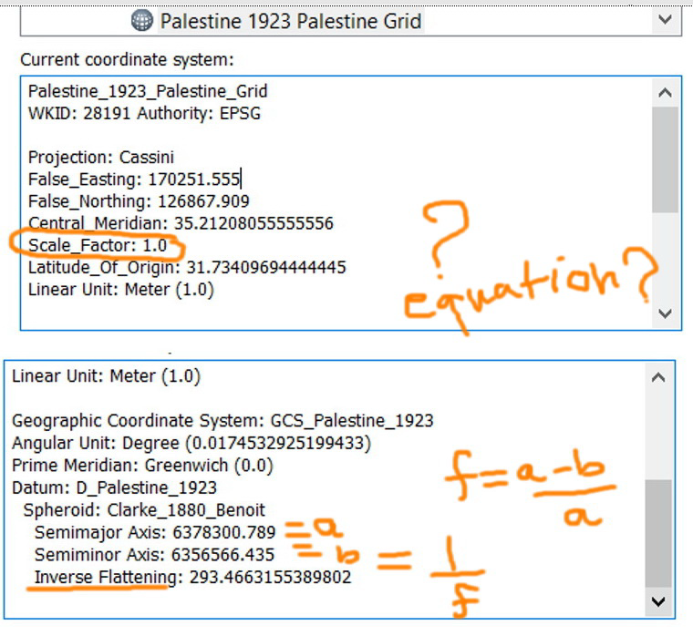
I couldn’t figure out if there are equations based on which the “Scale Factor” is calculated the same way we do for the flatness ((a-b)/a)
Jamal Numan
Geomolg Geoportal for Spatial Information
Ramallah, West Bank, Palestine
- Mark as New
- Bookmark
- Subscribe
- Mute
- Subscribe to RSS Feed
- Permalink
- Report Inappropriate Content
I'm sorry for the delay in responding.
When you see a scale factor listed among the projection parameters, it's a defining characteristic of the projected coordinate system. It is not the scale/distortion-at-a-point that can be calculated via a Tissot Indicatrix or other calculation. At some point, we do plan to add those types of calculations, but don't have them yet.
So for instance, in a Cassini projection, the scale factor sets the scale along the central meridian.
In a UTM zone, where the scale factor is 0.9996, that's the scale along the central meridian which means there are two lines (they are not quite longitude lines) approximately 180 km west and east of the central meridian that have scale = 1.
Melita
- Mark as New
- Bookmark
- Subscribe
- Mute
- Subscribe to RSS Feed
- Permalink
- Report Inappropriate Content
Thank you Melita for the input. This is very useful.
Jamal Numan
Geomolg Geoportal for Spatial Information
Ramallah, West Bank, Palestine