- Home
- :
- All Communities
- :
- Products
- :
- Imagery and Remote Sensing
- :
- Imagery Questions
- :
- Re: Add rasters to mosaic - performance
- Subscribe to RSS Feed
- Mark Topic as New
- Mark Topic as Read
- Float this Topic for Current User
- Bookmark
- Subscribe
- Mute
- Printer Friendly Page
Add rasters to mosaic - performance
- Mark as New
- Bookmark
- Subscribe
- Mute
- Subscribe to RSS Feed
- Permalink
- Report Inappropriate Content
Hi,
I was told by the ESRI support that in order to add rasters to mosaic, first it is recommended to "Import raster asc files into File Geodatabase"
Could you explain why?
Suggested workflow
...
• Import raster asc files into File Geodatabase (this will speed things up enormously!)
• Add rasters to mosaic
...
- Mark as New
- Bookmark
- Subscribe
- Mute
- Subscribe to RSS Feed
- Permalink
- Report Inappropriate Content
Hi Mark
I am not sure where you read this. Asc format is bot very good. It better be converted to some "good" raster format like tiff. You can use ASCII to Raster—Conversion toolbox | ArcGIS Desktop .
I do not see any reason to translate to file geodatabase and not to tiff.
Have fun
- Mark as New
- Bookmark
- Subscribe
- Mute
- Subscribe to RSS Feed
- Permalink
- Report Inappropriate Content
Hi Mody,
Thanks for your response.
I was told to do it by the local ESRI support.
The main task is to build a cache for an elevation image service. Should we first transform asc to tiff?
Have you seen the following issue (a gap in elevation image service in a web browser). But the mosaic dataset looks ok in ArcMap.
- Mark as New
- Bookmark
- Subscribe
- Mute
- Subscribe to RSS Feed
- Permalink
- Report Inappropriate Content
Hi Mark
I do not think you can build a mosaic directly from asc files since it is not "really" a raster. You should translate it first to a real raster. Why do you want to build a cache on elevation image service? On a dynamic image service you can build cool functions as slope, aspect etc. The cache will work a little faster but the different is not big (if you use tiff compressed in jpeg as source data).
I never saw any different between the mosaic and the image service build on top of it - it is basically different look on the same data. Your image looks as orthophoto drape on elevation. Are you sure your pure elevation looks correct in ArcMap?
Mody
- Mark as New
- Bookmark
- Subscribe
- Mute
- Subscribe to RSS Feed
- Permalink
- Report Inappropriate Content
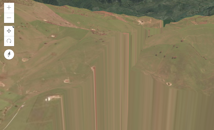
Yes, it is an ESRI orthophoto on our elevation image service.
It is common workflow to use a cached service. I will consider what you say - try transform to tiff and build after.
There is a test page (I uploaded to the topic - testMD_Elevation01_gaps_driver.html.zip)
- Mark as New
- Bookmark
- Subscribe
- Mute
- Subscribe to RSS Feed
- Permalink
- Report Inappropriate Content
Hi Everybody (hi Mody after a long time 🙂 ),
to put some things right: ASC IS a valid raster format - but as stated above it is not recommended for direct use in any usecase besides probably a "quick check" or "single user desktop" scenario. The reasons being:
- It is not indexed and has to be read sequential - slow to read
- It is not tiled (a lot like indexed above) - slow to access sub-areas
- It is uncompressed in terms of storing every single value - even if those values "repeat" a lot (think of no-data areas) - takes more space than needed
Especially when thinking about services on a long run, a "good format" (as it is called above) is much faster than ASC. There is hardy a comparison in terms of speed that is more obvious than ASC versus a good format - you can SEE the difference.
Depending on what you might want to do, yes, importing into a dataset in a fGDB MIGHT be a solution - in terms of "modern" raster handling, converting the asc-files into another suitable raster format is definitely more flexible. In the end you might create caches, exports, ... still for combining the data, deriving different products and appying process chains, a file-based MosaicDataset is a good way to go.
In terms of converting your rasters: PLEASE have a look at this: Esri Optimize Raster toolbox on GitHUB. It will help you here and in many other cases! Also - if creation, updating, modifying, deriving other "products" from it ... is important to you, check in MDCS on GitHUB, too.
Regards
Guenter