- Home
- :
- All Communities
- :
- Products
- :
- ArcGIS Network Analyst
- :
- ArcGIS Network Analyst Questions
- :
- Re: service areas
- Subscribe to RSS Feed
- Mark Topic as New
- Mark Topic as Read
- Float this Topic for Current User
- Bookmark
- Subscribe
- Mute
- Printer Friendly Page
service areas
- Mark as New
- Bookmark
- Subscribe
- Mute
- Subscribe to RSS Feed
- Permalink
- Report Inappropriate Content
Hello again,
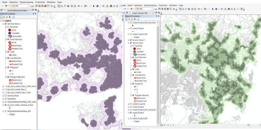
Now im in doubt because i'm doing service areas for two countries. The results are so different in shape.
As you can see by the left image, the areas are in circle, otherwise the right image we have square areas.
Why is this happening? Can you help me?
Thanks in advance.
- Mark as New
- Bookmark
- Subscribe
- Mute
- Subscribe to RSS Feed
- Permalink
- Report Inappropriate Content
if you did it the same way using the same criteria, that might mean that the road networks of the two countries differ in their general configuration. Or... you did something differently. Or both. You will have to backtrack from your assumption that the patterns should generate similar geometry
- Mark as New
- Bookmark
- Subscribe
- Mute
- Subscribe to RSS Feed
- Permalink
- Report Inappropriate Content
Im having "problemas" with my osm roads data.
Is there any tutorial with the steps to do with roads shapefile to have a network?
- Mark as New
- Bookmark
- Subscribe
- Mute
- Subscribe to RSS Feed
- Permalink
- Report Inappropriate Content
try to emulate the steps here
- Mark as New
- Bookmark
- Subscribe
- Mute
- Subscribe to RSS Feed
- Permalink
- Report Inappropriate Content
Take a look at : Network dataset It includes a discussion of OSM data.
As trusted colleague Chris Donohue, GISP likes to say Network Analysis = 1% Analysis + 99% Data Cleanup
- Mark as New
- Bookmark
- Subscribe
- Mute
- Subscribe to RSS Feed
- Permalink
- Report Inappropriate Content
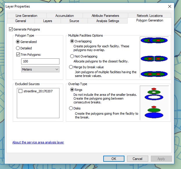
My first guess would be as Dan Patterson surmised, that the analysis was run with different settings. In particular, were the Polygon Generation settings the same between both runs? The Polygon Type and Trim Polygon settings can make a large difference in the output.
As Joe Borgione suggested, there are is some information available on how to work with OSM data. I don't know quite so much about this aspect, but this gentleman at Esri does, so let me tag him in case he can offer some more insight: Jay Sandhu
If connectivity in the network has come up as an issue, consider running Topology on the source data used to create the network dataset (if you have that available) to find any disconnects. Note that it is common to run into disconnects in street data, as often the data was created with CAD, which does not snap the line ends to be coincident.
In terms of building a functional network dataset, this Esri link is very helpful for the workflow and the various aspects one has to consider:
Creating a network dataset—Help | ArcGIS for Desktop
Chris Donohue, GISP
- Mark as New
- Bookmark
- Subscribe
- Mute
- Subscribe to RSS Feed
- Permalink
- Report Inappropriate Content
If you do find that data cleanup will be needed, consider downloading and installing this plug-in by GeoNet contributor timw1984 as a handy means to detect issues in your street linework.
Topology Check Python AddIn (6/30/17)
Chris Donohue, GISP