- Home
- :
- All Communities
- :
- User Groups
- :
- Archaeology GIS
- :
- Questions
- :
- Re: Creating a shovel test grid for Cultural Resou...
- Subscribe to RSS Feed
- Mark Topic as New
- Mark Topic as Read
- Float this Topic for Current User
- Bookmark
- Subscribe
- Mute
- Printer Friendly Page
Creating a shovel test grid for Cultural Resource Management
- Mark as New
- Bookmark
- Subscribe
- Mute
- Subscribe to RSS Feed
- Permalink
- Report Inappropriate Content
I can't find a good amount of information on creating a grid within a set boundary and using the intersection points as points for data. I work in the archaeology field and we dig shovel tests on a 50 foot grid. I am trying to figure out a way of creating a grid before entering the field, where each intersection point already has a distinct GPS point, and data can be entered via a database app in reference to each one of these points. Can anyone help me through this process?
I understand the fishnet tool, but not sure how to use the intersections and create points for each, and additional attributes to be filled in later. And how could I label each point based off of that grid system of x, y? For example, transect 1, shovel test 1.
- Mark as New
- Bookmark
- Subscribe
- Mute
- Subscribe to RSS Feed
- Permalink
- Report Inappropriate Content
Brian, this is exactly what I am looking for! I would love to see the code you used. Did you create a workflow model for the tool? Thank you thank you for this.
- Mark as New
- Bookmark
- Subscribe
- Mute
- Subscribe to RSS Feed
- Permalink
- Report Inappropriate Content
There are code samples here
here
https://community.esri.com/blogs/dan_patterson/2016/09/09/n-gons-regular-polygonal-shape-generation
and xander_bakker posted some as well which also does the labelling, but I can't put my hands on it.
The first link enables, rectangles or hexagon sampling frameworks with or without rotation.
- Mark as New
- Bookmark
- Subscribe
- Mute
- Subscribe to RSS Feed
- Permalink
- Report Inappropriate Content
Numpy is elegant, I suppose I will have to start over now. 🙂 Thanks for the link.
- Mark as New
- Bookmark
- Subscribe
- Mute
- Subscribe to RSS Feed
- Permalink
- Report Inappropriate Content
I think Dan Patterson is referring to How do I create and display the row and column of a hexagon grid and How can I assign grid values to the squares of a fishnet grid? but both threads are more about the labeling.
Dan also had this example Grid Reference Numbers in Fishnet that was mentioned in the same thread here: https://community.esri.com/message/698234-re-how-to-convert-overlay-grid-to-features
- Mark as New
- Bookmark
- Subscribe
- Mute
- Subscribe to RSS Feed
- Permalink
- Report Inappropriate Content
I set up a repository on github. I built a python toolbox too and I ran it successfully in ArcGIS Desktop 10.5.1
GitHub - Geo-CEG/shoveltest: Create grids to facilitate shovel tests for archaeology site work.
If you don't know how to use Github, please ask, I have been thinking of writing a blog post on it.
Please try this tool, I want it to work for you. I am sure there is plenty of tuning I could do on it but I'd like to hear if it is useful first. Next step in the workflow would be to convert the point grid into a GPX file; we should be able to do that in a model though.
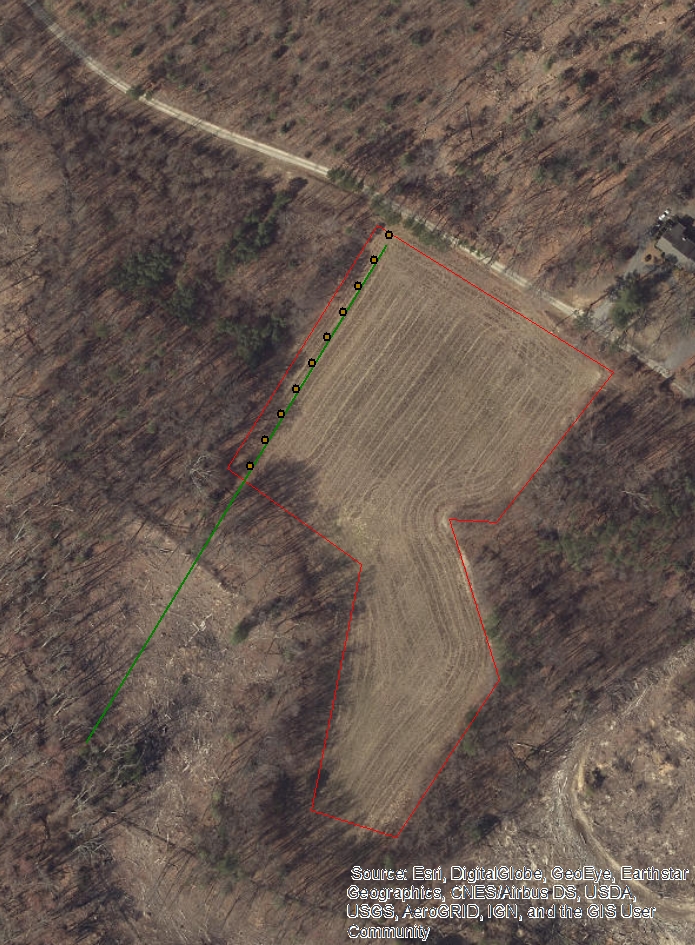
In this screenshot I was able to edit the baseline then run the tool right in ArcMap to generate a new grid. Note there are a couple wandering isolated points in this picture -- if a complete square does not fit it will get dropped but the points that still fit inside the polygon were not dropped.

- Mark as New
- Bookmark
- Subscribe
- Mute
- Subscribe to RSS Feed
- Permalink
- Report Inappropriate Content
Nice Brian!
GitHub's documentation is fairly good. But Dr. Google 'setting up a package' and other terms as well.
Also, you can link to ArcGIS Code Sharing (bottom left) and share your code from both, and maintain within GitHub
- Mark as New
- Bookmark
- Subscribe
- Mute
- Subscribe to RSS Feed
- Permalink
- Report Inappropriate Content
I used the "UPLOAD SCRIPTS" at the top of ArcGIS Code Sharing and it set up this in my ArcGIS.com account: Create Shovel Test Grid. However, nothing shows up anywhere that I can see at codesharing. Filtering on Github (by clicking "Github repository" under Result Type) gives Sorry. No results found.
- Mark as New
- Bookmark
- Subscribe
- Mute
- Subscribe to RSS Feed
- Permalink
- Report Inappropriate Content
I created a separate question (Code Sharing + Github does not work) since it's a bit off topic here.
- Mark as New
- Bookmark
- Subscribe
- Mute
- Subscribe to RSS Feed
- Permalink
- Report Inappropriate Content
Hi Brian, I've encountered an issue using the tool. My baseline starts at the upper corner of the red polygon and goes down and to left. When I run the tool, it only creates a single line of grid points along that edge within the polygon. Does the tool only draw in one direction from the baseline??

- Mark as New
- Bookmark
- Subscribe
- Mute
- Subscribe to RSS Feed
- Permalink
- Report Inappropriate Content
AH, it's rotated 180 degrees -- that is, it builds to the "right" of the line but that's with respect to the baseline so when the line goes north to south
you want to move it over to the other side. Maybe it should build squares on both sides of the baseline to make this easier? Then you could put it anywhere.