- Home
- :
- All Communities
- :
- Products
- :
- Imagery and Remote Sensing
- :
- Imagery Questions
- :
- Re: Feature extraction from LiDAR and derived rast...
- Subscribe to RSS Feed
- Mark Topic as New
- Mark Topic as Read
- Float this Topic for Current User
- Bookmark
- Subscribe
- Mute
- Printer Friendly Page
Feature extraction from LiDAR and derived rasters
- Mark as New
- Bookmark
- Subscribe
- Mute
- Subscribe to RSS Feed
- Permalink
- Report Inappropriate Content
Good morning all!
I am trying to obtain heights of man made structures and also update / create building footprints using LiDAR and the rasters I have created from them. I have gone through the this tutorial that explains how to create a DSM and DEM from LiDAR data (so I now have a DSM and DEM) and also this tutorial that explains how to get heights of trees (I just used the minus tool for the entire area and have heights for the entire area).
The issues I am running into for heights are the outliers in the LiDAR data. I have tried using the Locate Outliers tool, but it just keeps failing saying it can't locate my output table. These outliers skew data greatly when it comes to calculating average heights for buildings (I tested it on an existing polygon). I would like to reclassify these outliers as noise somehow if possible.
As for feature extraction, I really am a new guy when it comes to intense LiDAR analysis in ArcGIS and just am not sure where to begin. I know there are all kinds of paid for 3rd party extensions for LiDAR that include feature extraction, but alas we do not have the budget for such things....
Any help is much appreciated!
Rob
Solved! Go to Solution.
- Mark as New
- Bookmark
- Subscribe
- Mute
- Subscribe to RSS Feed
- Permalink
- Report Inappropriate Content
Arthur,
My LiDAR has 1 ft spacing. I starting the raster to polygon tool yesterday afternoon and it is still running today. Is this normal? I know my raster is pretty large. I'll just let is crank away I suppose.
Also, I ran into this article that outlines a different methodology for feature extraction. It was written by David Rohde, City of Edmonds. He goes through the same process of creating a DEM and DSM and using the Minus tool. However, to obtain stories for buildings, he uses the raster calculator to divide the resulting Minus raster by 8, converts raster to polygon, adds an area field, then selects all polygons with an area > 300 sq ft. It's a bit more of a dirty method but it looks like it would work. I am still going with what Arthur suggested as it sounds like the better methodology.
- Mark as New
- Bookmark
- Subscribe
- Mute
- Subscribe to RSS Feed
- Permalink
- Report Inappropriate Content
Hello Robert,
I would start with a small area to test with and get your parameters correct for your data. I 'm doing my processing with a model using an iterator with a grid over the area to do small areas and then merge together. One question is if your data is classified for buildings? Did your output raster show buildings with just one value and no data in the other areas? Also, was there holes in the buildings in the Raster. If so, run a Majority on it before converting to polygons.
On this article, it's uses Simplify Buildings instead of Regularize Building Footprints. He also says there is quite a bit of manual clean up, something I avoid as much as possible. I also suggest getting polygons over a certain size, I usually use 500 square feet as my input. There are many ways to get buildings from Lidar that have been developed, I sharing what has worked for me.
We have some additional tools for extraction we will be releasing on a website soon in prototype form that are alternatives to the process above.
Thanks,
Arthur Crawford
- Mark as New
- Bookmark
- Subscribe
- Mute
- Subscribe to RSS Feed
- Permalink
- Report Inappropriate Content
Arthur,
My data is classified and your method using LAS Points Stats as Raster worked out. The resulting raster does have holes. I tried the majority filter and it still has holes:
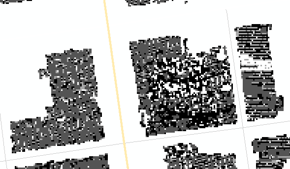
I converted it to polygons and got the following with holes still:

Would I use the integrate or dissolve tool to somehow fill these in? I'm looking what I can on the simplify building tool now.
- Mark as New
- Bookmark
- Subscribe
- Mute
- Subscribe to RSS Feed
- Permalink
- Report Inappropriate Content
Hi Robert,
I would suggest next time remapping/reclassify the image areas with data to one value. For where you are at now, run a dissolve on the polygons, then a positive buffer of 2 ft and then a negative buffer of -2ft. This should get rid of small holes and merge the multiple polygons your have. Then a multipart to singlepart. Then continue with the instruction for the Regularize Building Footprint.
Arthur Crawford - Content Team/Professional Services
- Mark as New
- Bookmark
- Subscribe
- Mute
- Subscribe to RSS Feed
- Permalink
- Report Inappropriate Content
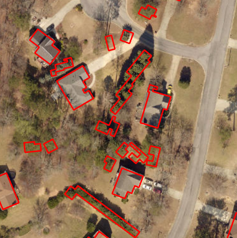
Arthur,
I now have my buidling footprints layer. I realize there is still a good bit of clean up (some footprints are merged into one large one, looks like some concrete structures that aren't buildings made it into class 6).
Thank you for your help!
- Mark as New
- Bookmark
- Subscribe
- Mute
- Subscribe to RSS Feed
- Permalink
- Report Inappropriate Content
Hi Robert,
I know you saw this, but wanted others to see it. There are two blogs on extracting features out there on Geonet.
Mine:
Arthur's Feature Extraction from LiDAR, DEMs and Imagery
Geoff's:
3D Workshop Feature Extraction Tools
Thanks,
Arthur
- Mark as New
- Bookmark
- Subscribe
- Mute
- Subscribe to RSS Feed
- Permalink
- Report Inappropriate Content
Hi Robert, we have a workshop on this workflow with step by step instructions using two methods 1) from Point Clouds 2) from rasters at the Esri Imaging and Mapping Forum this week in San Diego. Unfortunately you will have to attend to learn how. #IMF2016 #EsriUC Lineup of Speakers & #Technology http://dld.bz/egRY4 #Drones #Imagery #Lidar #mapping #GIS
We will give 2 workshops Drone2map 2D and 3D mapping, and Mapping from Point Clouds. Hope to see you there!
- Mark as New
- Bookmark
- Subscribe
- Mute
- Subscribe to RSS Feed
- Permalink
- Report Inappropriate Content
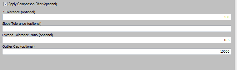
Unfortunately, I never was able to get the locate outliers to work correctly....ESRI doesn't have any good examples on how this tool should be properly used. I am attempting to filter out any LiDAR points that have more than 100 foot difference from the surrounding points. I set my comparison filter in the Locate Outliers tool as such:
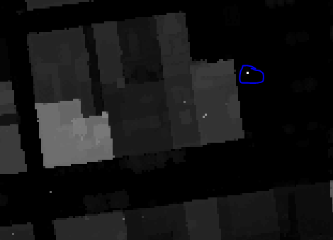
The output is not what I expect to see as I know where many outliers are but the tool is not flagging them.The following picture is a screenshot of the Minus tool output. The circled point says it is 1782 feet tall. Obviously this is not correct. The locate outliers tool does not flag any points in my LAS dataset near this point.
Now that I have my building footprints layer, I want to calculate the max z value / elevation for each polygon to get the building height using the Minus tool output. This outlier, if it were within a building footprint polygon, would then tell me my building is 1782 feet tall!
Am I misunderstanding how the locate outliers tool should be used? Is there a way to just locate local outliers from the Minus tool output raster?
Thank you again guys!
- Mark as New
- Bookmark
- Subscribe
- Mute
- Subscribe to RSS Feed
- Permalink
- Report Inappropriate Content
I've created a separate thread for this question that is awaiting approval to be posted:
- Mark as New
- Bookmark
- Subscribe
- Mute
- Subscribe to RSS Feed
- Permalink
- Report Inappropriate Content
Hi all, thanks a bunch for the tools, I'm getting alot of tree noise using these tools:
any ideas about how to curb this?