- Home
- :
- All Communities
- :
- User Groups
- :
- New to GIS
- :
- Questions
- :
- Properly exporting to KML for use in Google Maps
- Subscribe to RSS Feed
- Mark Topic as New
- Mark Topic as Read
- Float this Topic for Current User
- Bookmark
- Subscribe
- Mute
- Printer Friendly Page
Properly exporting to KML for use in Google Maps
- Mark as New
- Bookmark
- Subscribe
- Mute
- Subscribe to RSS Feed
- Permalink
- Report Inappropriate Content
I'm looking for some assistance in trying to get my company's current map files exported for use in Google Maps.
Quick little background on my project so I can hopefully give some context:
My company has a map that details all the international submarine fiber cables in the world. It's currently made with ArcGIS, where my coworker has simply drawn lines (polygons, I guess in ArcGIS?) to display all the routes instead of using coordinates. We are trying to export this to either Google Maps or Earth (trying to avoid the need for users to have a plugin installed for Earth, though) for an eventual interactive map and every time I try to import the KML file created via ArcGIS into Google Maps, the routes are either not displayed at all, or it's just random lines crisscrossed up and down the whole map.
So, my question is, is there a way to do what I want with a KML file that has no actual coordinate data? Is there a way to maybe add coordinate data to the existing shapefiles that are being used in ArcGIS? I admit I'm a bit out of my depth here, as I have very little experience with mapping software. I'm hoping there's a solution I can make use of, otherwise I'm going to be stuck redrawing everything by hand myself.
Please let me know if there is any more information needed to help solve this. I'm not sure if I'll be able to make KML/shapefiles available for people to look at, but I will try to make that happen if necessary.
Solved! Go to Solution.
Accepted Solutions
- Mark as New
- Bookmark
- Subscribe
- Mute
- Subscribe to RSS Feed
- Permalink
- Report Inappropriate Content
If your shapefiles or feature classes have an unknown coordinate system one could try the below workflow.
Find the coordinate system used to make the original data. Open the ArcMap doc where the shapes are displaying correctly. Then open the data frame proprieties. Then go to the coordinate system tab.

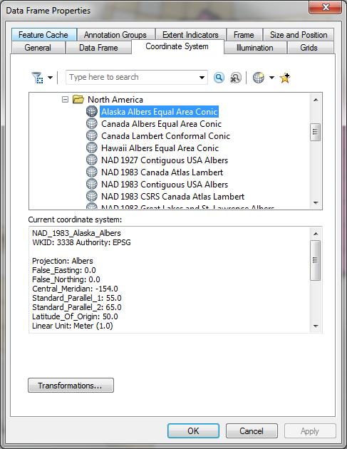
Note the system in the Current coordinate system field.
Now use define projection to set the system in the problem data sets.
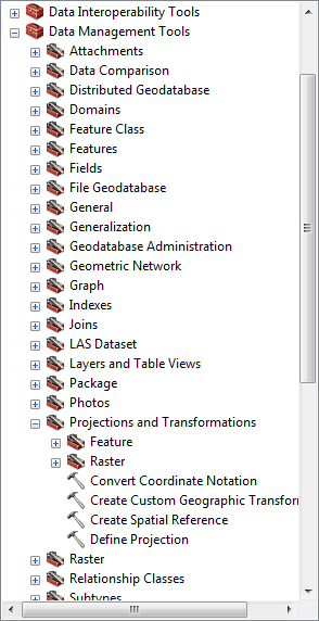
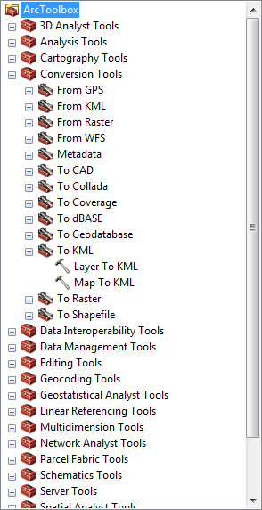
Then export to KML most likely with Layer to KML
Hope this helps
- Mark as New
- Bookmark
- Subscribe
- Mute
- Subscribe to RSS Feed
- Permalink
- Report Inappropriate Content
Hi Wayne,
I would recommend looking into ArcGIS Online. If your company has ArcGIS Desktop, you are entitled to an ArcGIS Online subscription.
ArcGIS Online allows users to create, use, share, and discover web maps/applications. These maps/applications can be accessed on a desktop, mobile device, or tablet (no plug-in required). Also, no need to convert your shapefile to another format. You can easily add your shapefile to an ArcGIS Online web map.
- Mark as New
- Bookmark
- Subscribe
- Mute
- Subscribe to RSS Feed
- Permalink
- Report Inappropriate Content
If your shapefiles or feature classes have an unknown coordinate system one could try the below workflow.
Find the coordinate system used to make the original data. Open the ArcMap doc where the shapes are displaying correctly. Then open the data frame proprieties. Then go to the coordinate system tab.
Note the system in the Current coordinate system field.
Now use define projection to set the system in the problem data sets.
Then export to KML most likely with Layer to KML
Hope this helps
- Mark as New
- Bookmark
- Subscribe
- Mute
- Subscribe to RSS Feed
- Permalink
- Report Inappropriate Content
Thank you SO much! This is EXACTLY what I needed!