- Home
- :
- All Communities
- :
- User Groups
- :
- New to GIS
- :
- Questions
- :
- I have a water polygon that I need to chop out isl...
- Subscribe to RSS Feed
- Mark Topic as New
- Mark Topic as Read
- Float this Topic for Current User
- Bookmark
- Subscribe
- Mute
- Printer Friendly Page
I have a water polygon that I need to chop out island polygons from
- Mark as New
- Bookmark
- Subscribe
- Mute
- Subscribe to RSS Feed
- Permalink
- Report Inappropriate Content
I have a polygon shapefile that represents a large body of water. I have a separate polygon shapefile that represents all the islands within that water polygon.
I tried to merge them but that just puts one on top of the other.
what I need is to basically chop out the islands from the water so I end up with a file that's nothing but water. I've looked through the tools but I'm not sure which one is appropriate.
Solved! Go to Solution.
Accepted Solutions
- Mark as New
- Bookmark
- Subscribe
- Mute
- Subscribe to RSS Feed
- Permalink
- Report Inappropriate Content
1). The easiest option is to use Erase (Analysis). However, you will need to have an Advanced license to have access to that tool.
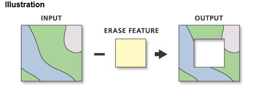
ArcGIS Help 10.1 - Erase
2). An alternative if one doesn't have an Advanced License level of ArcMap is to use Union (Analysis), which is available at all license levels, and then look at the resulting attributes. Two fields will be added, one for each of the input layers. You can use those two new fields to evaluate whether the polygons are from one layer or another. Then select the ones you want and save off to a new feature class and you are done (or you can start an edits session and delete based on a selection of the unwanted polygons).
The output feature class will contain a FID_<name> attribute for each of the input feature classes. For example, if one of the input feature classes is named Soils, there will be a FID_Soils attribute on the output feature class. FID_<name> values will be -1 for any input feature (or any part of an input feature) that does not intersect another input feature. Attribute values for the other feature classes in the union where no intersection is detected will not be transferred to the output feature in this case.
ArcGIS Help 10.1 - Union
Chris Donohue, GISP
- Mark as New
- Bookmark
- Subscribe
- Mute
- Subscribe to RSS Feed
- Permalink
- Report Inappropriate Content
- Mark as New
- Bookmark
- Subscribe
- Mute
- Subscribe to RSS Feed
- Permalink
- Report Inappropriate Content
1). The easiest option is to use Erase (Analysis). However, you will need to have an Advanced license to have access to that tool.
ArcGIS Help 10.1 - Erase
2). An alternative if one doesn't have an Advanced License level of ArcMap is to use Union (Analysis), which is available at all license levels, and then look at the resulting attributes. Two fields will be added, one for each of the input layers. You can use those two new fields to evaluate whether the polygons are from one layer or another. Then select the ones you want and save off to a new feature class and you are done (or you can start an edits session and delete based on a selection of the unwanted polygons).
The output feature class will contain a FID_<name> attribute for each of the input feature classes. For example, if one of the input feature classes is named Soils, there will be a FID_Soils attribute on the output feature class. FID_<name> values will be -1 for any input feature (or any part of an input feature) that does not intersect another input feature. Attribute values for the other feature classes in the union where no intersection is detected will not be transferred to the output feature in this case.
ArcGIS Help 10.1 - Union
Chris Donohue, GISP
- Mark as New
- Bookmark
- Subscribe
- Mute
- Subscribe to RSS Feed
- Permalink
- Report Inappropriate Content
luckily one of our licenses is for advanced, so I just tried it and it did the trick.
thank you for the fast responses.
adding this to my notes.
- Mark as New
- Bookmark
- Subscribe
- Mute
- Subscribe to RSS Feed
- Permalink
- Report Inappropriate Content
Dear Tim
Easiest way is to use cut polygon. Go through link so you can know how to do it.