- Home
- :
- All Communities
- :
- Products
- :
- ArcGIS Spatial Analyst
- :
- ArcGIS Spatial Analyst Questions
- :
- Re: Problem with raster Reclassify in python scrip...
- Subscribe to RSS Feed
- Mark Topic as New
- Mark Topic as Read
- Float this Topic for Current User
- Bookmark
- Subscribe
- Mute
- Printer Friendly Page
Problem with raster Reclassify in python script
- Mark as New
- Bookmark
- Subscribe
- Mute
- Subscribe to RSS Feed
- Permalink
- Report Inappropriate Content
Cross posting: Python
I'm writing a python tool that given a elevation raster (elevation value in meters), converts to a "raster object" with elevation value in feet. I then create a variable based on elevation Range provided be the user to be used with the Reclassify command as a RemapRange. The result of this Reclassify (and maybe one other step eventually) will be input to RasterToPolygon
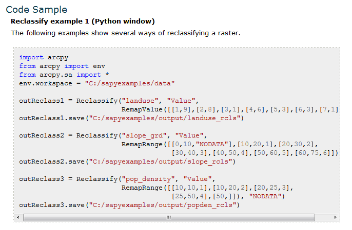
I've included a very simplified version of the code I have,
The out value of my reclassArg is
[[327.850126532, 1000, 1000], [1000, 2000, 2000], [ 2000, 3000, 3000], [ 3000, 6500, 6500]]
But I have also tried version such as
327.850126532 1000 1000; 1000 2000 2000; 2000 3000 3000; 3000 6500 6500
and all different variations of the two, based on the "results" snippet, and various help docs.
I've tried quite a few different commands and versions of the reclassArg, with the last being from the local ArcGIS 10.3 tool help
But my output raster keeps come out with a single value 127. Full disclosure, before I tried
outDEMtmp = Reclassify(elevFeet, "Value", RemapRange("{0}".format(reclassArg)), "NODATA")
or
outDEMtmp = arcpy.sa.Reclassify(elevFeet, "Value", RemapRange("{0}".format(reclassArg)), "NODATA")
and even
arcpy.gp.Reclassify_sa(elevFeet, "Value", reclassArg, outDEMtmp, "NODATA")
The first two (using the [[ ]] list as reclassArg) finishes without an erro, but all values are are "127"
The third option is not reclassifying anything.
I admit my spatial analyst skills are very rusty, and the raster-object concept is new (all though similar to the old GRID), but I'm running out of ideas to try, other than running the tools manually. Any help or a good resource on scripting the Reclassify tool would be helpful.
Using 10.3, ArcInfo/Advanced and Spatial Analyst (I have access to 3D if needed).
import os
import arcpy
from arcpy import env
from arcpy.sa import *

arcpy.CheckOutExtension("spatial")

theWorkspace = r"C:\_beartest\Prep.gdb"
arcpy.env.workspace = theWorkspace
arcpy.env.overwriteOutput = True
wsPath, wsGDB = os.path.split(theWorkspace)

rasterIn = r"C:\_beartest\Unit20Araster.gdb\elevClip"

toElevFeet = 3.280839895013123

elevFeet = (Raster(rasterIn) * toElevFeet)
elevMinimum = elevFeet.minimum

elevCutoffFt = "6500"
flatElevBreak = ("1000; 2000; 3000")

# processing the elevation and high-cuttoff variables to create reclass arguments
elevSplit = flatElevBreak.split(";")
lstCnt = 1
for reclassValue in elevSplit:
    print(reclassValue)
    print("Reclass value:{0} ft".format(reclassValue))
    if lstCnt == 1:
        reclassArg = ("[[{0}, {1}, {2}]".format(elevMinimum, reclassValue, ("{0}".format(reclassValue))))
    else:
        reclassArg = ("{0}, [{1}, {2}, {3}]".format(reclassArg, prevValue, reclassValue, ("{0}".format(reclassValue))))
    lstCnt += 1
    prevValue = reclassValue
reclassArg = ("{0}, [{1}, {2}, {3}]]".format(reclassArg, prevValue, elevCutoffFt, ("{0}".format(elevCutoffFt))))
print(reclassArg)

outDEMtmp = arcpy.sa.Reclassify(elevFeet, "Value", RemapRange("{0}".format(reclassArg)), "NODATA")
outDEMtmp.save(elevReclass)

print("hello2")
#arcpy.RasterToPolygon_conversion(outDEMtmp, "reclassPoly", "SIMPLIFY", "VALUE")

arcpy.CheckInExtension("spatial")
Suggestions would be greatly appreciated. Thanks
EDIT: added line 18 which was missing.
Message was edited by: Rebecca Strauch, GISP EDIT: added line 18 which was missing.
Solved! Go to Solution.
- Mark as New
- Bookmark
- Subscribe
- Mute
- Subscribe to RSS Feed
- Permalink
- Report Inappropriate Content
I tried that, but that didn't help any. Still getting 127. I've tried various versions of the reclassArg formatting and using the remap = and using the RemapRange(reclassArg) with various formatting...both with .0 and without. All either they come out as 127 or it just doesn't reclass.
Maybe Curtis will have some other ideas. Otherwise, hopefully tech support will have some ideas. I'm getting close to giving up for the night.
- Mark as New
- Bookmark
- Subscribe
- Mute
- Subscribe to RSS Feed
- Permalink
- Report Inappropriate Content
I was thinking about his idea of doing it all at once, after building the remap table
eg.
remap = RemapRange([[1000, 2000, 1], [2000, 3000, 2], [3000, 4000, 3]]
out_reclass = Reclassify(raster, "Value", remap, "NODATA")
- Mark as New
- Bookmark
- Subscribe
- Mute
- Subscribe to RSS Feed
- Permalink
- Report Inappropriate Content
So, that worked, but I need to get my reclassArg, which will be created on the fly, into that format. I've been working on that.
EDIT: after quite a bit more manipulation in getting my reclassArg into a list, I also realized for some reason it wants the new value to not be the same as my reclassValue. No sure what the reason is for that right now, but at least now I might be able to clean it up and get it to work in the morning.
EDIT2: cleaned up script a little...this is a snippet of what ended up working. Super quick now, so I can now continue on. Thanks for you help Dan (and Curtis Price via the other thread). It was my reclassArg not being formatted correctly all along.
flatElevBreak = ("1000; 2000; 3000")

elevFeet = (Raster(rasterIn) * toElevFeet)
elevMin = elevFeet.minimum
elevMax = elevFeet.maximum
print("\n Elevation raster source: {0}".format(elevFeet))

# processing the elevation and high-cuttoff variables to create reclass arguments
elevSplit = flatElevBreak.split(";")
lstCnt = 1
reclassArg = []
for reclassValue in elevSplit:
    print(reclassValue)
    print("Reclass value:{0} ft".format(reclassValue))
    if lstCnt == 1:
        reclassArg.append([int(elevMin), int(reclassValue), lstCnt])
    else:
        reclassArg.append([int(prevValue), int(reclassValue), lstCnt])
    lstCnt += 1
    prevValue = reclassValue
reclassArg.append([int(prevValue), int(elevCutoffFt), lstCnt])
reclassArg.append([int(elevCutoffFt), int(elevMax), 9])
print("{0}".format(reclassArg))
remap  = RemapRange(reclassArg)
print("{0}".format(remap))

# Process: Reclassify
outDEMtmp = Reclassify(elevFeet, "Value", remap, "NODATA")

print("hello2")
arcpy.RasterToPolygon_conversion(outDEMtmp, "reclassPoly", "SIMPLIFY", "VALUE")
Dan, no need to keep refining the code...it works, it's readable...time for me to move on. 
- Mark as New
- Bookmark
- Subscribe
- Mute
- Subscribe to RSS Feed
- Permalink
- Report Inappropriate Content
sorry It is late, I was thinking about how you put it together as well
minelev = 649
elevs = [1000,2000,3000]
elevs.insert(0,minelev)
remap = [[elevs[i-1],elevs,elevs] for i in range(1,len(elevs))]
print("remap ... {}".format(remap))
#out_reclass = Reclassify(raster, "Value", remap, "NODATA") # then do this thing
print yields remap ... [[649, 1000, 1000], [1000, 2000, 2000], [2000, 3000, 3000]]
ADDENDUM
an example from one of Curtis's remap examples for weighted overlay
Re: Assign Dynamic Influence % to Weighted Overlay Table for Weighted Overlay Analysis
- Mark as New
- Bookmark
- Subscribe
- Mute
- Subscribe to RSS Feed
- Permalink
- Report Inappropriate Content
I'm at a loss.
Dan/Curtis, et al., please send any suggestions if you have them, but time to put in a tech support ticket. Most likely it is my just interpreting the help somehow, but having it comes out as one big 127 value has really got me stumped. I even tried running it against the original elevation raster (meters) and it came out the same, so it has to be something with my range argument.
- « Previous
-
- 1
- 2
- Next »
- « Previous
-
- 1
- 2
- Next »