- Home
- :
- All Communities
- :
- Products
- :
- Mapping
- :
- Mapping Questions
- :
- Re: Help analyzing a map
- Subscribe to RSS Feed
- Mark Topic as New
- Mark Topic as Read
- Float this Topic for Current User
- Bookmark
- Subscribe
- Mute
- Printer Friendly Page
Help analyzing a map
- Mark as New
- Bookmark
- Subscribe
- Mute
- Subscribe to RSS Feed
- Permalink
- Report Inappropriate Content
So, I'm looking to build maps for personal use using ArcMap 10.1. These would be used as trail maps to navigate local trail systems. I want to base my map's style off another I've found online. I'm looking for help breaking down that found map. It's posted below.
Note - I'm searching for help deducing the layers, and their type, not the title, legend, pictures, compass, and description
What what I see in terms of layers includes:
1. Raster - topographic. Is there style name for this sort of topographic map (contour lines and elevation divided by color).
2. GPS Data of trails
3. Civil Boundries
4. Hydrology
I think the most impressive part of this map is the raster data. Any suggestions on where I could find such data for upstate New York with high enough resolution to have the maps printed.
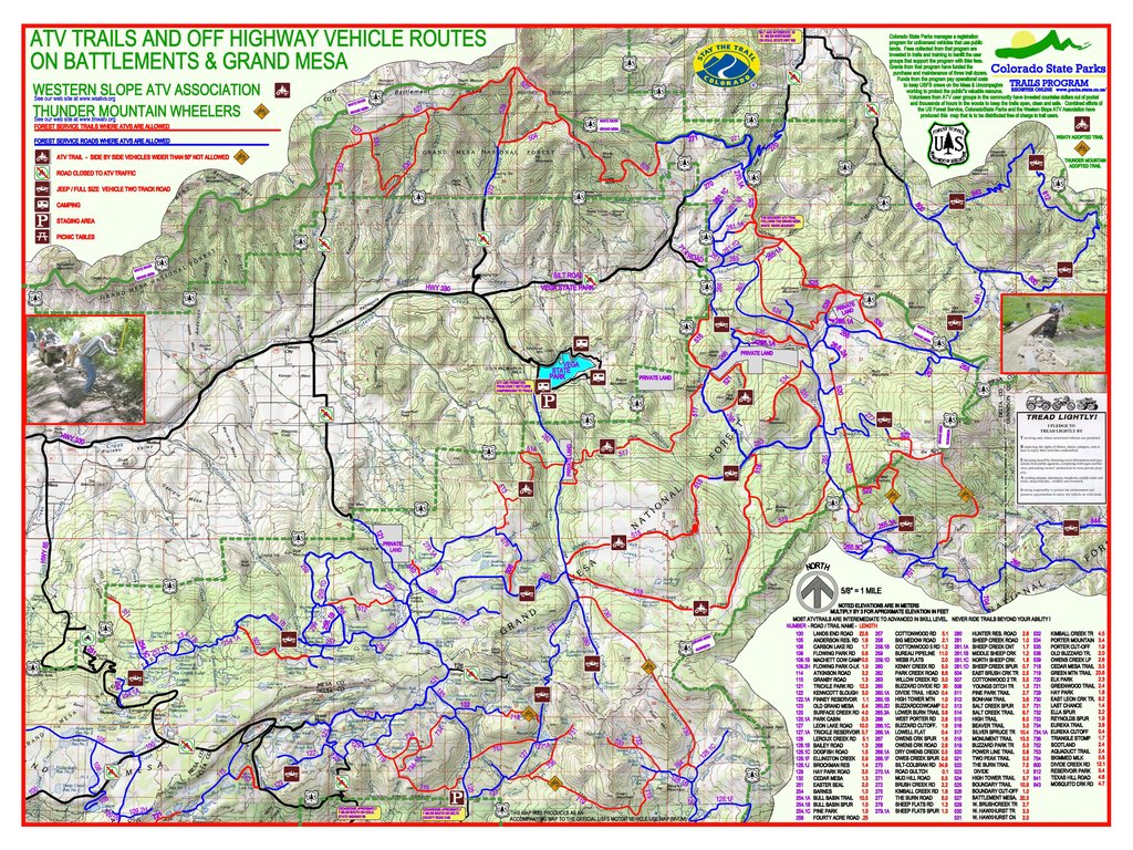
Thanks to the guys at Colorado State Park Trail Program for building this great map!
- Mark as New
- Bookmark
- Subscribe
- Mute
- Subscribe to RSS Feed
- Permalink
- Report Inappropriate Content
- Mark as New
- Bookmark
- Subscribe
- Mute
- Subscribe to RSS Feed
- Permalink
- Report Inappropriate Content
Yes I meant like that
- Mark as New
- Bookmark
- Subscribe
- Mute
- Subscribe to RSS Feed
- Permalink
- Report Inappropriate Content
Also the USGS Historic Topos have a lot of other data built into them, such as streams, tree coverage(green shading, though somewhat dated), geomorphologic feature labels, etc. Trying to recreate most of these would be rather time consuming.
P.S. I find it funny Dan Patterson hasn't responded to daniel patterson's post yet. It would amuse me greatly if he would.
- Mark as New
- Bookmark
- Subscribe
- Mute
- Subscribe to RSS Feed
- Permalink
- Report Inappropriate Content
Sadly...I don't make maps often, unless it is from my own data Numpy Lessons... # 6 ... Creating data for testing purposes... and even then I don't need to see it, to know what it looks like ... so I have little to contribute to where to get data and how to map it 
The Original
- Mark as New
- Bookmark
- Subscribe
- Mute
- Subscribe to RSS Feed
- Permalink
- Report Inappropriate Content
Ian Murray for example, in forest knutsen reference about the pyramids...
novice pyramid builders... pardon the font
Simple pyramid-ish array... shape (19, 19), ndim 2 ready for interpolation/contouring and shading
Simple pyramid array... shape (19, 19), ndim 2
[[0 0 0 0 0 0 0 0 0 0 0 0 0 0 0 0 0 0 0]
 [0 1 1 1 1 1 1 1 1 1 1 1 1 1 1 1 1 1 0]
 [0 1 2 2 2 2 2 2 2 2 2 2 2 2 2 2 2 1 0]
 [0 1 2 3 3 3 3 3 3 3 3 3 3 3 3 3 2 1 0]
 [0 1 2 3 4 4 4 4 4 4 4 4 4 4 4 3 2 1 0]
 [0 1 2 3 4 5 5 5 5 5 5 5 5 5 4 3 2 1 0]
 [0 1 2 3 4 5 6 6 6 6 6 6 6 5 4 3 2 1 0]
 [0 1 2 3 4 5 6 7 7 7 7 7 6 5 4 3 2 1 0]
 [0 1 2 3 4 5 6 7 8 8 8 7 6 5 4 3 2 1 0]
 [0 1 2 3 4 5 6 7 8 9 8 7 6 5 4 3 2 1 0]
 [0 1 2 3 4 5 6 7 8 8 8 7 6 5 4 3 2 1 0]
 [0 1 2 3 4 5 6 7 7 7 7 7 6 5 4 3 2 1 0]
 [0 1 2 3 4 5 6 6 6 6 6 6 6 5 4 3 2 1 0]
 [0 1 2 3 4 5 5 5 5 5 5 5 5 5 4 3 2 1 0]
 [0 1 2 3 4 4 4 4 4 4 4 4 4 4 4 3 2 1 0]
 [0 1 2 3 3 3 3 3 3 3 3 3 3 3 3 3 2 1 0]
 [0 1 2 2 2 2 2 2 2 2 2 2 2 2 2 2 2 1 0]
 [0 1 1 1 1 1 1 1 1 1 1 1 1 1 1 1 1 1 0]
 [0 0 0 0 0 0 0 0 0 0 0 0 0 0 0 0 0 0 0]]
import numpy as np
def pyramid(core=9, steps=10, incr=(1,1)):
    """create a pyramid with a core value, a certain number of steps
      decreasing by incr until done
    """
    a = np.array([core])
    a = np.atleast_2d(a)
    for i in range(1,steps):
        a = np.lib.pad(a,incr,"constant",constant_values=(core-i,core-i))
    print("\nSimple pyramid array... shape {}, ndim {} \n{}".format(a.shape,a.ndim,a))
    return a
if __name__=="__main__":
    a = pyramid()
- Mark as New
- Bookmark
- Subscribe
- Mute
- Subscribe to RSS Feed
- Permalink
- Report Inappropriate Content
This is a really intense way to think about map making. baby steps, baby steps I tell myself.
Scripting is a skills that I would like to get into, sooner than later. It seems to have limitless possibilities in the analysis, management, and utilization of data. Currently I'm working on building a map of a local trail system nearby my home. Once after I hope to develop a larger regional map through the same techniques I'm learning at the local level. Then, I plan to tap into Esri's Mapbook functions using the Arc platform + Python to write my own script useful to build my own book. But already, I'm well over my head. Again, baby steps.. baby steps
- Mark as New
- Bookmark
- Subscribe
- Mute
- Subscribe to RSS Feed
- Permalink
- Report Inappropriate Content
Right, it can be a lot of information. Even people who do GIS professionally can quickly get in over their heads when exploring a new part of the discipline . The field is truly massive. It includes IT infrastructure, software development, cartography, remote sensing, etc....
I and others on this thread have talked a little bit about the underpinnings of the technology/science/art of GIS. However to just make a map the background information, while important and relevant, is not absolutely necessary.
If I where you I would start by finding a DEM, then look at symbolizing it. Here is some info on hillshade.
http://resources.arcgis.com/en/help/main/10.1%20/index.html#//009t0000007q000000
- Mark as New
- Bookmark
- Subscribe
- Mute
- Subscribe to RSS Feed
- Permalink
- Report Inappropriate Content
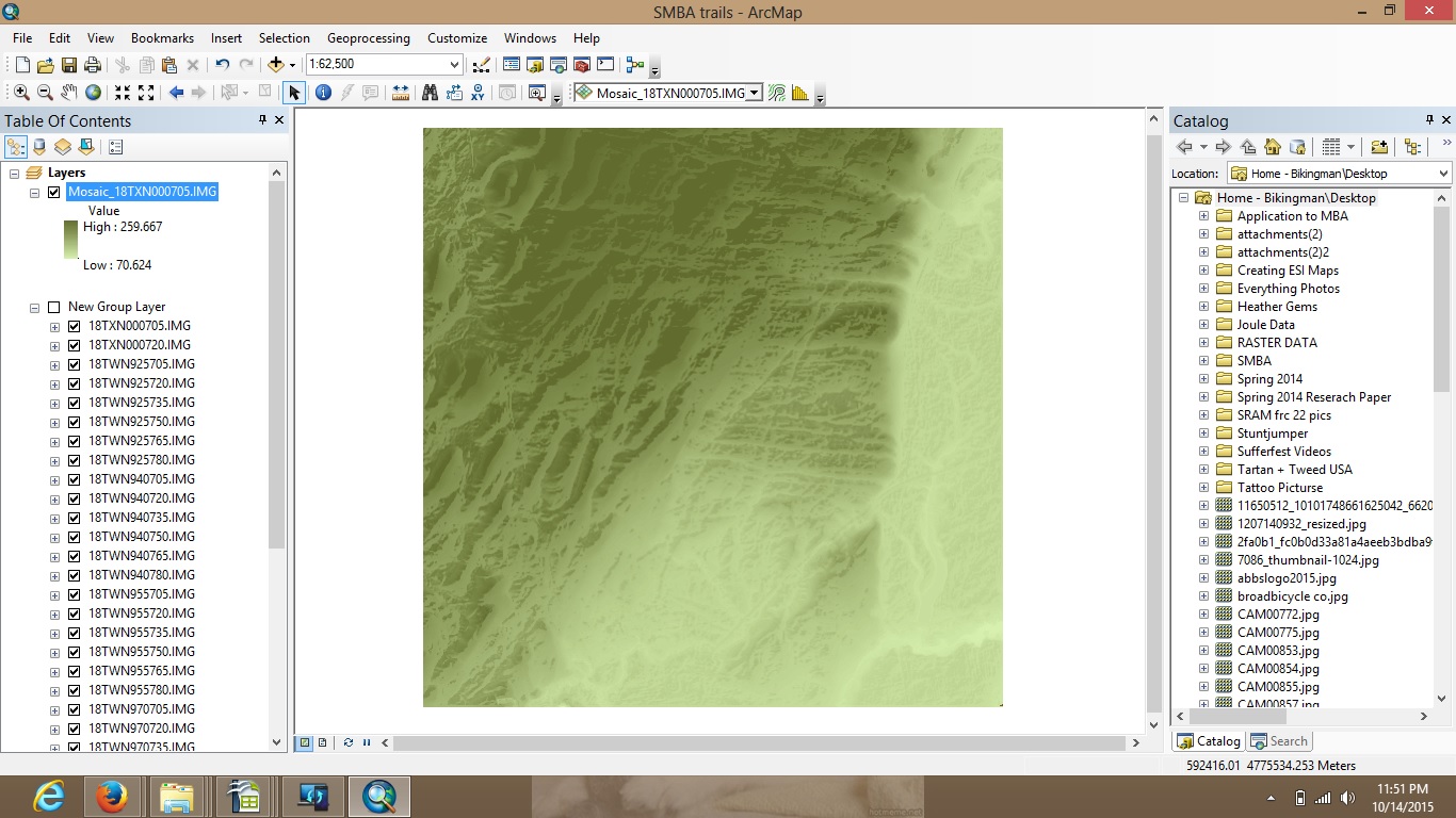
I've been able to create a regional map using DEM tile data and the the mosaic function. Colored it, and added hill shade. Tomorrow I'll look to building in the road and water data. I hope to frame everything as well. Next week I'll head out to the trails and gather the correct GPS data. Should get me close to finishing this project. Recently I found out that the GPS data which we have, although accurate, can't be used because it is not quite up to date with what actually in the woods. It doesn't reflect the current trail structure. Recently, the DEC bought the parcel of land and restructured the trails. Some of our trails were, how you say, slightly outside the parcel box. Our recorded data reflects the pre-restructuring. Perhaps TMI but, a story shared.
Learning how to use ArcMap 10.1 functionally seems to be a one-project/problem-at-a-time sort of process. I'm excited to keep up the learning.
p.s. - any advice on the map is very welcome!
- Mark as New
- Bookmark
- Subscribe
- Mute
- Subscribe to RSS Feed
- Permalink
- Report Inappropriate Content
I have changed this thread from a question to a discussion to better reflect its contents.
- Mark as New
- Bookmark
- Subscribe
- Mute
- Subscribe to RSS Feed
- Permalink
- Report Inappropriate Content
Thank you Dan Patterson
- « Previous
-
- 1
- 2
- Next »
- « Previous
-
- 1
- 2
- Next »