- Home
- :
- All Communities
- :
- Industries
- :
- Water Resources
- :
- Water Resources Questions
- :
- Re: ArcHydro Problem Solvers
- Subscribe to RSS Feed
- Mark Topic as New
- Mark Topic as Read
- Float this Topic for Current User
- Bookmark
- Subscribe
- Mute
- Printer Friendly Page
- Mark as New
- Bookmark
- Subscribe
- Mute
- Subscribe to RSS Feed
- Permalink
- Report Inappropriate Content
- Make sure the Geoprocessing extents include the whole project: Go to the Geoprocessing menu>Environments...>Processing Extent. Under Processing Extent choose a layer that you know covers the full extent of the waters you are processing and click OK. This should ensure that the processing extent is large enough to do what you want.
- Delete everything you can in your temp folder: Mine is C:\Users\mboucher\AppData\Local\Temp. Get out of ArcMap first to clear temp files related to your project. You can do this without getting out of ArcMap through the ArcHydro Toolbar under ApUtilities>Additional Utilities>Clean User's Temp Folder.
- Make sure your Target Locations are correct: Under ApUtilities>Set Target Locations, make sure the HydroConfig and they GeoHMSConfig Targets make sense. The raster data should go to the project folder vector data to a geodatabase. The raster data will go to a folder in the project folder with the dataframe name and the vector data to a feature data set with the dataframe name. Through the ArcHydro Toolbar under there is a function to reset the target locations: ApUtilities>Additional Utilities>Reset Target Locations. I've not tested this to see if it corrects everything.
- When working on a complicated model, don't use the model mxd for your presentation map. It just adds baggage to an already "heavy" mxd.
Solved! Go to Solution.
- Mark as New
- Bookmark
- Subscribe
- Mute
- Subscribe to RSS Feed
- Permalink
- Report Inappropriate Content
Hi Mr Boucher,
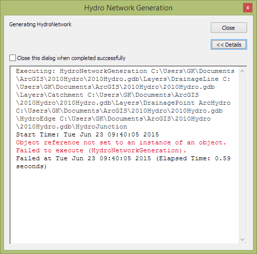
I am currently performing a hydrologic analysis of a filled 5m raster DEM (dendritic). I have already been able to perform pre-processing via the basic dendritic terrain workflow in GP tools. However I am now trying to perform the Hydro Network generation. I am getting an error message shortly after executing the command. I have tried things mentioned including deleting the folders and geodatabases and starting again, setting geoprocessing extents, clearing temporary files. However I have not been successful. I will keep trying things but just wondering if you had any ideas on how to get around this?
Regards,
Glen
- Mark as New
- Bookmark
- Subscribe
- Mute
- Subscribe to RSS Feed
- Permalink
- Report Inappropriate Content
Glen,
I've just got a few minutes and then need to head out of the office.
This is a very common error that could mean a number of things (not that I know what they are!). I did a little search and found a thread on the error. c# - What is a NullReferenceException and how do I fix it? - Stack Overflow I guess "Object Reference Not Set to an Object" can also be called "Null Reference Exception". Subheadings at the link above seem to make more sense than the techno-talk in the post. It looks like the error comes up when the program runs across a "Null" value in a variable. Make sure the features have values in key fields.
Naming conventions is one that I've found is important. In the screen capture you posted it looks like you are using default names and they don't have any spaces. Sometimes the name length can cause problems. You could try creating a project directory that is not as "deep". I use C:/GIS/<Project> for my work. I save the mxd with relative paths and then move the project to a server that is backed up later.
Don't have more time to help. Sorry!
Mark
- Mark as New
- Bookmark
- Subscribe
- Mute
- Subscribe to RSS Feed
- Permalink
- Report Inappropriate Content
Come explanations regarding Catchments vs AdjointCatchments and Watersheds vs. Subwatersheds are here: Catchment vs watershed
- Mark as New
- Bookmark
- Subscribe
- Mute
- Subscribe to RSS Feed
- Permalink
- Report Inappropriate Content
Hi Everyone,
I'm stumped and wondering if someone can help explain something. I'm using ArcHydro to do some analysis where there are known sinks, and trying to use the Flow Direction with Sinks tool. In the resulting Fdr grid, I'm used to seeing only the D8 directions (1,2,4,8,16,etc.), but i'm now seeing around 60 different numbers in the VALUE field ranging from 1 to 255. The non-D8 values do not have a high cell COUNT relative to the D8 but they are not insignificant. Is this correct and should I continue with my analysis, or is there something wrong here?
thanks,
Carlisle
- Mark as New
- Bookmark
- Subscribe
- Mute
- Subscribe to RSS Feed
- Permalink
- Report Inappropriate Content
I have not used the flow direction with sinks tool. I look forward to seeing a solution to your problem.
Mark
- Mark as New
- Bookmark
- Subscribe
- Mute
- Subscribe to RSS Feed
- Permalink
- Report Inappropriate Content
Thanks for your extremely useful thread on troubleshooting ARCHYDRO. I've implemented your suggestions and I'm still getting the same error when I attempt to run the depression evaluation tool. I'm attempting to run this tool on a 1m LIDAR DEM about 650 mb in size, that has already been prescreened for small sinks. The tool will run up to the drainage area calculation step and then crash with the following message:
System.Runtime.InteropServices.COMEXCEPTION (0x80041098): Error 010316: Unable to open the input raster: C:\USERS\DAN\APPDATA]LOCAL\TEMP\ARCFFE6\AH2015~1\G_G2011
Any thoughts on what might be causing this error?
Thanks so much
Dan
- Mark as New
- Bookmark
- Subscribe
- Mute
- Subscribe to RSS Feed
- Permalink
- Report Inappropriate Content
Hi Dan,
What format is the input raster? Make sure it's an esri GRID format, and make sure it's saved in a folder, not a geodatabase. Also make sure than none of your outputs are set to intermediate, if you're using a model.
Carlisle
- Mark as New
- Bookmark
- Subscribe
- Mute
- Subscribe to RSS Feed
- Permalink
- Report Inappropriate Content
Hi,
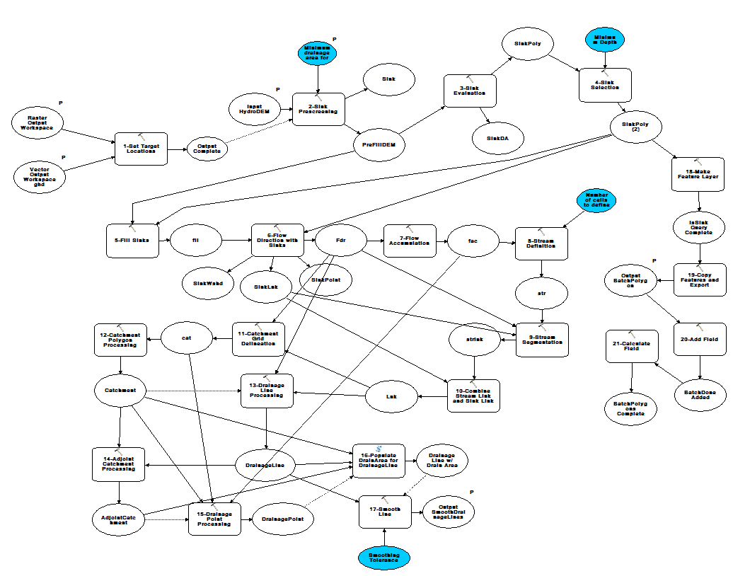
I've been having an issue with ArcHydro models for some time now, and finally have some time to look into it. The model i'm working with gives me what I want, but it keeps deleting some of the output after it runs, or after the mxd is saved and reopened. This happens to only a few of the outputs, but happens every time usually to the same ones, which are both raster and vector. They are behaving as though they are set to Intermediate, but that is definitely not the case and I also make sure to add them to the display and save the mxd. Fortunately, this does not happen to the ultimate outputs which I need, like fdr (flowdirection) but it makes it very difficult and frustrating to go back and troubleshoot or tweak the model since I lose several steps along the way. I don't have the time to go piece by piece, running the model, and figuring out what happens at every step along the way, so I'm hoping someone has encountered this before or has any thoughts. Below is a screen shot of the model, with the steps numbered in order. The outputs which have a tendency to vanish after the model completes are PreFillDEM, SinkPoly, and fil...where do they go and why?!?
- Mark as New
- Bookmark
- Subscribe
- Mute
- Subscribe to RSS Feed
- Permalink
- Report Inappropriate Content
My practice is to create a tool box and put several models in it. I start the names of the models with numbers so I can keep the order straight. The models may have a dozen steps or just a couple. This is how I've kept one crash from a big model from requiring a whole new start.
I also will sometimes if errors are persistent, I close the mxd and delete all the output (gdbs and all). I keep any of the main inputs. Then I reboot. This is sometimes the only thing that gets me past an error. Never know why this is, but it works.
- Mark as New
- Bookmark
- Subscribe
- Mute
- Subscribe to RSS Feed
- Permalink
- Report Inappropriate Content
I want to use a shapefile I have for a lake as the only sink in a deranged basin, but the Create Sink Structures routine will not accept the shapefile. Is this because it expects to find HydroIDs in the attribute table?