- Home
- :
- All Communities
- :
- Products
- :
- ArcGIS Spatial Analyst
- :
- ArcGIS Spatial Analyst Questions
- :
- Why do I get error message when creating interpola...
- Subscribe to RSS Feed
- Mark Topic as New
- Mark Topic as Read
- Float this Topic for Current User
- Bookmark
- Subscribe
- Mute
- Printer Friendly Page
Why do I get error message when creating interpolation from point data to raster via spatial analysis tool?
- Mark as New
- Bookmark
- Subscribe
- Mute
- Subscribe to RSS Feed
- Permalink
- Report Inappropriate Content
Hello
I am having a series of issues with my new installation of Arc 10.2 and Microsoft Office 2013, which I had been plagued with for the last two weeks. The most recent now is that I can not do any interpolation work as I keep getting a series of errors.
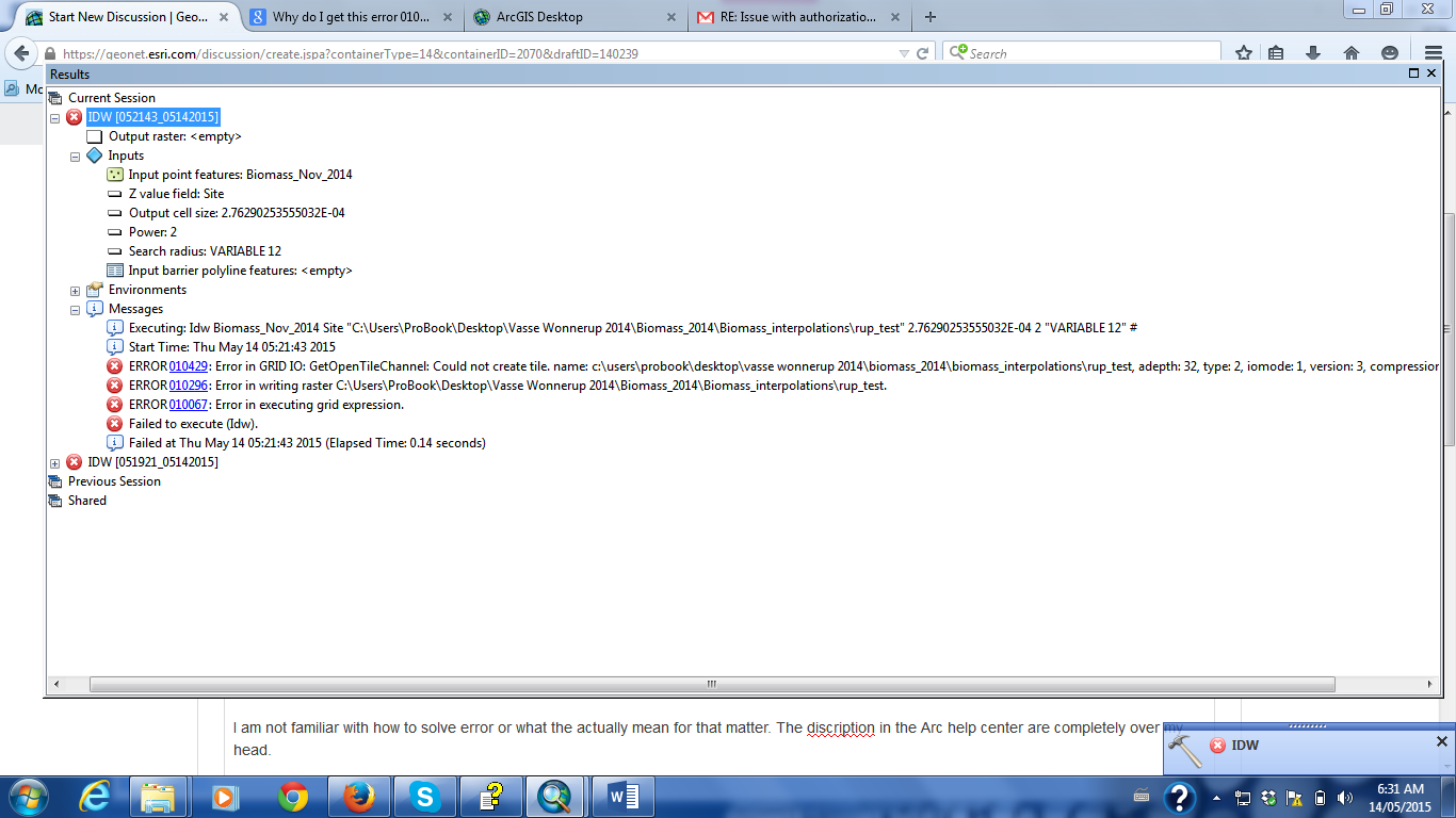
Error: 010429 Error in Grid
Error: 010296 Error in writing raster
Error: 010067 Error in executing grid expression
Failed to execute (idw)
Now I am trying to interpolation to a raster from a point file via the spatial analysis tool using IDW as the method of interpolation, which I have been doing for several years now without any issues (Note: I am now using a new computer, new ArcSoftware and the latest Mircosoft 2013 software...if this make any difference?//...).
I've inserted a print screen of these error messages...I hope this will help
I am not familiar with how to solve error or what they actually mean for that matter. The description in the Arc help center are completely over my head.
As I mentioned I have had a series of issues with the compatibility between Microsoft Office and Arc 10.2. For example, I was able to import (add) my Excel spreadsheets into Arc via "Add data> add XY data, but then could not create an xy event...without it having to be saved in the default folder. I did manage to create a shapefile for the added XY data...and thought all would be sweet, but now I can not do the next processing step of interpolation the point data (shapefile) to raster.
If someone could please help me with this issue, that would be great. I am now several weeks behind in my work and my deadline is approaching in a week.
Thanks for you time.
Cheers
Jess
- Mark as New
- Bookmark
- Subscribe
- Mute
- Subscribe to RSS Feed
- Permalink
- Report Inappropriate Content
It's a long shot, but you might try creating a workspace directly in the root of your c drive and setting that as your output workspace in environment settings. You might also try having your workspace be a file geodatabase instead of a folder.
- Mark as New
- Bookmark
- Subscribe
- Mute
- Subscribe to RSS Feed
- Permalink
- Report Inappropriate Content
Reproject your point data to a projected coordinate System. And try saving the output raster file in a basic folder as a TIFF file (.tif).
And try using a shorter pathname like "D:\Project\Biomass2014"
Think Location
- Mark as New
- Bookmark
- Subscribe
- Mute
- Subscribe to RSS Feed
- Permalink
- Report Inappropriate Content
And your paths have spaces in them
- Mark as New
- Bookmark
- Subscribe
- Mute
- Subscribe to RSS Feed
- Permalink
- Report Inappropriate Content
If the above suggestions don't work, I'd also try using a shorter filename (along with a shorter file path) and not use the underscore in the file name. For example, go with a very brief filename of "rt" and Jaynata's suggestion of a file path to see it that will allow it to run.
I mention this as sometimes the issue seems to be if the combined file path and file name is long it causes issues, even though in theory it should work as it is within the published limits.
If this works, you can always rename the file and move it.
Chris Donohue, GISP
- Mark as New
- Bookmark
- Subscribe
- Mute
- Subscribe to RSS Feed
- Permalink
- Report Inappropriate Content
Jessica
Run the tool in foreground mode, i.e. Geoprocessing->Geoprocessing Options and uncheck the Background Processing Enable button.
-Steve
- Mark as New
- Bookmark
- Subscribe
- Mute
- Subscribe to RSS Feed
- Permalink
- Report Inappropriate Content
Would be a lot more helpful to have the entire path so i could see what your path names here.
You can get the messages as text by right clicking Messages, Copy.
It's very important when working with rasters to set the geoprocessing environment for current and scratch workspace, and to stick with raster names that follow the following rules:
- < 13 characters
- start with a letter
- name made up of only [a-z] [0-9] _
- total pathname < 128 characters (though Chris is totally right, shorter is better)
- Mark as New
- Bookmark
- Subscribe
- Mute
- Subscribe to RSS Feed
- Permalink
- Report Inappropriate Content
Curtis, I think you do see her whole path name if you click on the screenshot image.
- Mark as New
- Bookmark
- Subscribe
- Mute
- Subscribe to RSS Feed
- Permalink
- Report Inappropriate Content
well there is a space in the path and it is reallly really long...I gave up after 70. the filename is short enough, but the cell size is 2ish E-04 ?? If this is projected data, you have issues...if it isn't projected data, it should be. As suggested, in Chris's thread, you seem to meet most criteria....except for the spaces I mentioned...project the data to a suitable coordinate system (eg. UTM), choose a realistic cell and specify an Esri grid by leaving off the extension on the output name.
Next time, report the extents, coordinate system etc to facilitate making this a protracted thread.
- Mark as New
- Bookmark
- Subscribe
- Mute
- Subscribe to RSS Feed
- Permalink
- Report Inappropriate Content
Thank you all for your posts and help. I have got it working now. Yahoo!
Sorry for the late reply. I am actually working remotely in the Solomon Islands and internet is terrible here...but this has been compounded by storming weather. Needless to say, I was unable to responded to any of the suggest until today.
As I suspected, the issue does not seem to be with my naming system (I have been doing this same contract work for four years now and have name everything the same).
Also, I did not change the coordinate system as I left it as is. However the issue did appear to be in the geoprocessing environments settings >Workspace>Output coordinates>processing extent. When I changed these setting the cell size changed to a good procession extent.
So thank you all very much for the help. I have never gone on to the forum before and was very impressed with all the helpful suggestions.
Cheers
Jess