- Home
- :
- All Communities
- :
- Industries
- :
- Water Resources
- :
- Water Resources Questions
- :
- Re: ArcHydro Problem Solvers
- Subscribe to RSS Feed
- Mark Topic as New
- Mark Topic as Read
- Float this Topic for Current User
- Bookmark
- Subscribe
- Mute
- Printer Friendly Page
- Mark as New
- Bookmark
- Subscribe
- Mute
- Subscribe to RSS Feed
- Permalink
- Report Inappropriate Content
- Make sure the Geoprocessing extents include the whole project: Go to the Geoprocessing menu>Environments...>Processing Extent. Under Processing Extent choose a layer that you know covers the full extent of the waters you are processing and click OK. This should ensure that the processing extent is large enough to do what you want.
- Delete everything you can in your temp folder: Mine is C:\Users\mboucher\AppData\Local\Temp. Get out of ArcMap first to clear temp files related to your project. You can do this without getting out of ArcMap through the ArcHydro Toolbar under ApUtilities>Additional Utilities>Clean User's Temp Folder.
- Make sure your Target Locations are correct: Under ApUtilities>Set Target Locations, make sure the HydroConfig and they GeoHMSConfig Targets make sense. The raster data should go to the project folder vector data to a geodatabase. The raster data will go to a folder in the project folder with the dataframe name and the vector data to a feature data set with the dataframe name. Through the ArcHydro Toolbar under there is a function to reset the target locations: ApUtilities>Additional Utilities>Reset Target Locations. I've not tested this to see if it corrects everything.
- When working on a complicated model, don't use the model mxd for your presentation map. It just adds baggage to an already "heavy" mxd.
Solved! Go to Solution.
- Mark as New
- Bookmark
- Subscribe
- Mute
- Subscribe to RSS Feed
- Permalink
- Report Inappropriate Content
Hello, I have been using Arcmap version 10.2.2 and have failed to recondition the DEM using the GEO-HMS steps. I have read the above posts with no luck and have had the following results:
1) The surface reconditions but only over the stream and ignores the surface surrounding it. (checked the negative space to see if i interpreted this wrong but this was not the case)
2) Allows me to recondition all the way to polygon processing however fails to continue from there. (This happened once in 2 days of attempting this)
Is this an arcmap version issue?
EDIT: The error for HEC-Geo HMS can all be fixed with changing the target location to an .mdb rather than a .gdb.
This was mentioned in a post above but it was a solution for 10.1; however works in 10.2.2 as well.
- Mark as New
- Bookmark
- Subscribe
- Mute
- Subscribe to RSS Feed
- Permalink
- Report Inappropriate Content
I don't find the GeoNet forum that easy to use. I'm going to try out Geographic Information Systems Stack Exchange and see if it is a good replacement. I'll still look here from time to time. If GeoStacker works better, I may abandon this format. Just not that good of a format for a forum. Go to this discussion to see what others think.
https://community.esri.com/polls/1059?et=watches.email.poll_comment#comment-6408
- Mark as New
- Bookmark
- Subscribe
- Mute
- Subscribe to RSS Feed
- Permalink
- Report Inappropriate Content
A DEM Reconditioning problem was solved. Could be a memory issue. See thread at DEM Reconditioning >> Empty AgreeDEM
- Mark as New
- Bookmark
- Subscribe
- Mute
- Subscribe to RSS Feed
- Permalink
- Report Inappropriate Content
Hello Every One
How do I get Bathmetry data
I would like to use it in hydrodynamic modelling.
Thank you.
- Mark as New
- Bookmark
- Subscribe
- Mute
- Subscribe to RSS Feed
- Permalink
- Report Inappropriate Content
Some who follow Arc Hydro or this thread might have info on bathymetry, but you'll have a better chances of finding an answer if you go to the main GeoNet page and search bathymetry. You might find a broader audience for your question there. This thread is specific to ArcHydro and does not specifically cover data sources.
Here's a good example of what you could find with such a search.
- Mark as New
- Bookmark
- Subscribe
- Mute
- Subscribe to RSS Feed
- Permalink
- Report Inappropriate Content
Mark: First of all I apologize for re-posting my query from another forum thread. I get the following error (see attached). I have made sure the target locations are set correctly as you have described. My files are on local drive, and I have also gone through most of the useful suggestions you have provided in this post, but with no success.
Can you kindly guide me in solving this error.
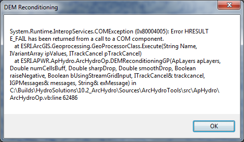
System Info:
Windows 7, 64 bit
ArcGIS 10.2, ArcHydro for 10.2
- Mark as New
- Bookmark
- Subscribe
- Mute
- Subscribe to RSS Feed
- Permalink
- Report Inappropriate Content
Well... it is tax day...
Seriously, this is one of those "generic" error messages. I seems like you are doing things that reduce this error: local drive, target locations, etc. Make sure you have the Spatial Analyst extension turned on and make sure the layers are all in the same coordinate system.
Even recently I had some problems with the catchment polygon processing (raster to polygon). It took a PC reboot to "fix" it. I'm at a loss to understand the cause. It has been working fine lately.
The Arc Hydro processing is doing a lot. Sometimes I sense that I get an error if it has been a while since I saved or closed and restarted ArcMap. I have never heard anyone talk about this, but I wonder if the "undo" list gets too long for ArcMap to keep track of when doing all the geoprocessing and that causes a memory or other problem.
I will soon be getting v10.2.2 and so I'll be able to experience upgrade errors then. Maybe its a version issue.
Sorry I can't be of more specific help.
- Mark as New
- Bookmark
- Subscribe
- Mute
- Subscribe to RSS Feed
- Permalink
- Report Inappropriate Content
I just got 10.2.2 installed on a laptop and am testing the new version of Arc Hydro. All worked well until I got to fill sinks. After restarting ArcMap, etc., I reset the processing extents to be that of the rawdem I'm using: an area a little bigger than my study extents. All worked smoothly after that!
So, somewhere in the process, Arc Hydro might change or set the processing extents and if all does not work just right, it doesn't get changed back and that causes problems. If you have problems, see if that fixes it.
It would be nice if Arc Map had a way to show me what the processing extents are or had a way in Model builder to have a layer (like rawdem) be used to set the processing extents for the mxd. Those features would be really nice.
- Mark as New
- Bookmark
- Subscribe
- Mute
- Subscribe to RSS Feed
- Permalink
- Report Inappropriate Content
Sir,
I have similar problems, as you mentioned, with DEM Fill. In fact, I am having all these problems while working on the tutorial data as prescribed by ArcHydro itself so I assume the fault is not in the data. I use Windows 8.1 and ArcMap 10.2.2. I do get a feeling that the error may be due to incorrect target location, which I am unable to locate as it is not mentioned clearly for Win 8.1 ( There is no C:/Users/Temp...). Also, I don't understand what " donot store a raster in a geodatabase" means. Can you please help me with this. I get the same error message as Mr. Mallya has with his problems in DEM Reconditioning.
Thank you.
- Mark as New
- Bookmark
- Subscribe
- Mute
- Subscribe to RSS Feed
- Permalink
- Report Inappropriate Content
I just posted something about Target Locations at Re: Batch point generation not working.
As for the storing the raster in a geodatabase: This can be done, but Arc Hydro, be default, keeps the raster data in a separate folder. See the link above regarding target locations.