- Home
- :
- All Communities
- :
- Products
- :
- ArcPad
- :
- ArcPad Questions
- :
- How to add a map service from my Arcmap server to ...
- Subscribe to RSS Feed
- Mark Topic as New
- Mark Topic as Read
- Float this Topic for Current User
- Bookmark
- Subscribe
- Mute
- Printer Friendly Page
How to add a map service from my Arcmap server to Arcpad?
- Mark as New
- Bookmark
- Subscribe
- Mute
- Subscribe to RSS Feed
- Permalink
- Report Inappropriate Content
How can I add a map service from my Arcmap server to Arcpad
many thanks
Ahmad
Solved! Go to Solution.
Accepted Solutions
- Mark as New
- Bookmark
- Subscribe
- Mute
- Subscribe to RSS Feed
- Permalink
- Report Inappropriate Content
Hi Ahmad,
If you open the 'Add Data from Server' tool and enter the address of your server, you should be able to see your map services and add them to ArcPad. There are a few rules that you need to follow for map services, so please read the relevant help topic here and keep the following in mind:
- The map service must use the Web Mercator projection.
- You must create a map cache on the server.
- The map cache must include the highest level of detail, Layer 0 (equivalent to the extent of the world).
Thanks,
Hannah
- Mark as New
- Bookmark
- Subscribe
- Mute
- Subscribe to RSS Feed
- Permalink
- Report Inappropriate Content
Many thanks Hannah,
It worked with me, but how could I overcome the problem of projection because my map services have different projections, and I need to publish them in with my own projection not with Web Mercator and still read them in arcpad. Is there any work around to do this ?
Any help is appreciated.
Thanks,
Ahmad
- Mark as New
- Bookmark
- Subscribe
- Mute
- Subscribe to RSS Feed
- Permalink
- Report Inappropriate Content
Hannah,
I've been through the articles on how to create an AGS service for ArcPad. They suggest using exploded format, but don't specify an image storage type. The default is MIXED, which will create both PNG (blank or partially so) tiles and JPEG (content tiles).
I added the service to ArcPad to make sure the NMF and L00-L03 folders were created, then took the map service offline. I then copied all the tiles from the map service's cache folder into the NMF file's cache location.
The cache does indeed work offline, but it looks like it's turning everything into PNG files with world files and a projection xml. In this screenshot, the JPG files are what was copied from the AGS service's cache directory, and the PNG, PGW, and xml files were created by ArcPad when viewing the layer:
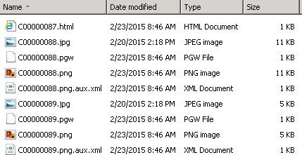
Is this the way it's supposed to function, or is there some ArcPad setting I need to change? If it's the intended behavior, this will more than double the cache's size when using it.
- Mark as New
- Bookmark
- Subscribe
- Mute
- Subscribe to RSS Feed
- Permalink
- Report Inappropriate Content
Hi Nate ,
Despite the fact that I have followed the three rules in order to read an map service in ArcPad 10.2.1, the ArcPad still fails to read the map service and shows the error HTTP error 400 , which is found to be a bug in ArcPad 10.2.1 and 10.2.2, So its not useful to consume a map service in ArcPad also that you should use Web Mercator projection not you preferred projection