- Home
- :
- All Communities
- :
- Products
- :
- ArcGIS Pro
- :
- ArcGIS Pro Ideas
- :
- Store and Use GeoPackage FeatureClass Extents
- Subscribe to RSS Feed
- Mark as New
- Mark as Read
- Bookmark
- Follow this Idea
- Printer Friendly Page
- Report Inappropriate Content
Store and Use GeoPackage FeatureClass Extents
- Mark as New
- Bookmark
- Subscribe
- Mute
- Subscribe to RSS Feed
- Permalink
- Report Inappropriate Content
As opposed to QGIS, ArcGIS Desktop + Pro do not store or use extent information when storing feature classes in a GeoPackage. The following screenshot is from a GeoPackage gpkg_contents table where the first 3 feature classes where created by QGIS and the last one by ArcGIS Desktop.
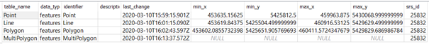
When adding a GeoPackage feature class with many hundreds of thousands of features to ArcMap as a feature layer, it takes quite a long time to calculate its extent. This could be avoided if ArcMap used the extent information from the gpkg_contents table instead. Therefore, all ArcGIS applications should write this information to the GeoPackage and use it when accessing the data.
You must be a registered user to add a comment. If you've already registered, sign in. Otherwise, register and sign in.