- Home
- :
- All Communities
- :
- Products
- :
- ArcGIS Pro
- :
- ArcGIS Pro Ideas
- :
- Enhance ArcGIS Pro Bin functionality
- Subscribe to RSS Feed
- Mark as New
- Mark as Read
- Bookmark
- Follow this Idea
- Printer Friendly Page
- Report Inappropriate Content
- Mark as New
- Bookmark
- Subscribe
- Mute
- Subscribe to RSS Feed
- Permalink
- Report Inappropriate Content
I used the new 'binning" functionality for the first time today in ArcGIS Pro 2.4. Here are the things that I would like to see changed:
- Enable binning for file geodatabase layers. I don't have an enterprise geodatabase. In order to use binning, I had to use SQL Express, which I prefer not to do.
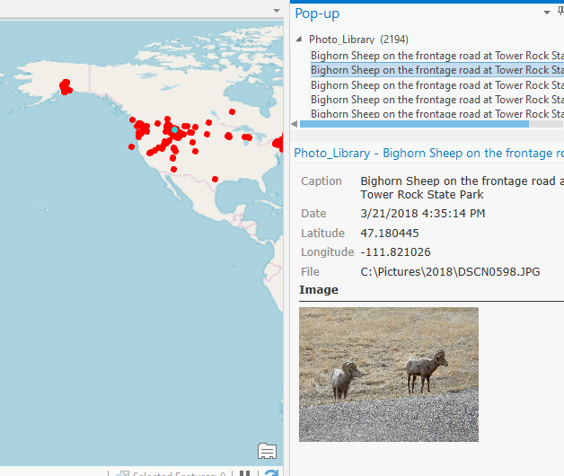
- I would like the identify tool to pop-up all of the features in the bin I click on, rather than statistics about the bin. I know based on using the tool with the features in my layer that it will be painfully slow for bins with lots of data, but it would be really, really, really handy for the small bins.
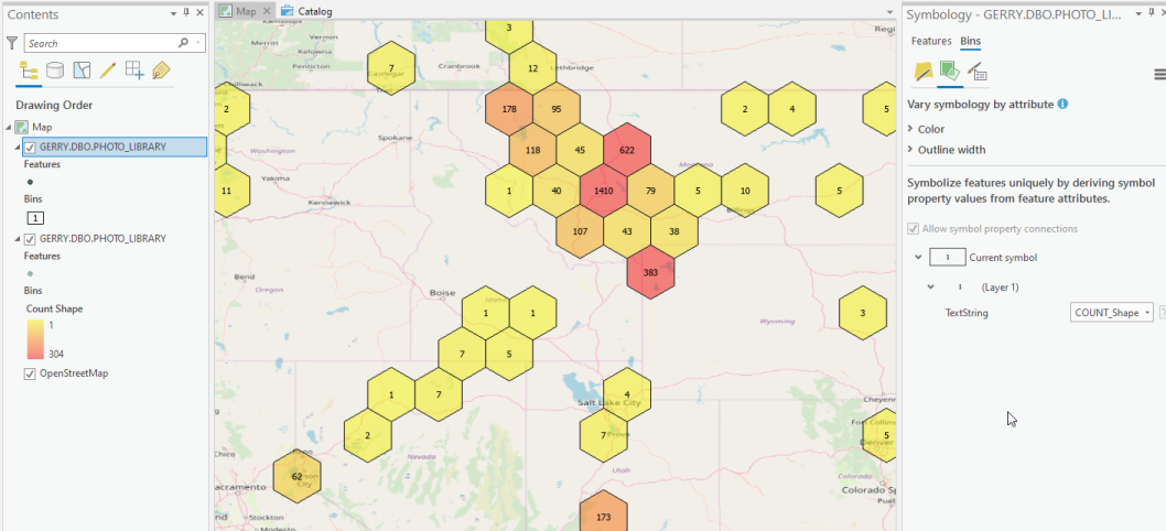
- Allow labeling the bins with their statistics in conjunction with the unclassed colors option. This is only available with the single symbol option. To do both, you have to put the layer in the map twice:
- It would be nice if the table of contents only showed the active symbol for the layer, rather than both the bins and the features.
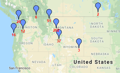
- Allow the use of point symbols similar to what my photo management software, ACDSee, uses. This is probably a Google Maps thing:
 My problems with ACDSee are that it only lets you map one folder at a time, and it does not allow geocoding of videos. So I'm trying to use ArcGIS Pro for it instead.
 - Make the bins use 50% transparent polygon fill symbols by default. That's what all the examples show, and I can't image that anyone would want the bin polygons to cover up their base map data:
 - No.
- No.
- Mark as Read
- Mark as New
- Bookmark
- Permalink
- Report Inappropriate Content
Thank you for sharing your thoughts on how to improve feature binning, Gerald. As for folks voting on this, there are 6 different things here, so if somebody supports this, does it mean they fully support all 6 things, or that they really only want to see feature binning for file geodatabase?
Which of the 6 is most important to you? Is 1 the most important and 6 the least important?
I'll make sure that they development teams in charge of feature binning see these requests, but not sure how actionable this is as a single idea.
Thank you.
- Mark as Read
- Mark as New
- Bookmark
- Permalink
- Report Inappropriate Content
Thank you, Kory. I went back and sorted the bullets in order of how important they are to me.
- Mark as Read
- Mark as New
- Bookmark
- Permalink
- Report Inappropriate Content
Hi Gerald, number 3 should be possible, although it is not completely straightforward.
Can you follow the steps on this web help page and let us know if you see issues again with the Unclassed symbols?
- Mark as Read
- Mark as New
- Bookmark
- Permalink
- Report Inappropriate Content
Thank you. This does work for me. There is however, nothing intuitive about finding this setting. I will always have to follow the instructions to be able to do it. I don't understand what "Template" means in the Primary Symbology Tab, and I don't understand why a symbol layer called "Shape Marker" would be the thing to provide a text label. It isn't obvious at all that the "Text String" option allows the text string to be based on the feature count. If I hover over the database icon, I see that $feature_COUNT_Shape is the "Property mapped to expression", but if I click on it, the only option in the drop-down list is <None>.
If I go back and select something from the drop-down list on the "Form" line, every bin now gets marked with the same symbol, and I don't know how to get back to where there is a "Shape text symbol" option with a Text string field. I have to remove the layer from the map and add it back in again.
- Mark as Read
- Mark as New
- Bookmark
- Permalink
- Report Inappropriate Content
Hi @KoryKramer and @GregoryLehner ,
I was going over my old Ideas content and found that I should update this one. At the time I submitted this Idea, I was not aware of the Clusters option for feature symbology. Perhaps Clusters were not an option at that time.
I would rate this Idea as something like 90-95% satisfied. The little tweaks remaining in the list below are not important to me but they would be nice. I don't know if my complaints for Bins are still valid or if people who still use Bins would want my previous suggestions to still be considered.
Here is a new complaint for Clusters, and how Clusters change my previous complaints. I will re-submit this as a new Idea
- Put a Clusters or Aggregation option in the Symbology window. I was not aware of the Feature Layer Drawing group in the Ribbon before. This group is probably something I will continue to not use or remember the existence of. I will always have to use Google to find the Clusters option.
- Enable Binning for file geodatabase layers. I don't care - Clusters solve my problem
- I would like the Identify tool to pop-up all of the features in the bin I click on. Yes, I would still like this for my Clusters
- Allow labeling the bins with their statistics. I don't care if this is made easier for Bins - Clusters solve my problem
- It would be nice if the table of contents only shows the active symbol for the layer, rather than both the bins and the features. Yes, I would still like this for my Clusters, but it isn't a big deal. I see a problem with this request, in that it is very difficult for me to find any sub-extent of my data set that displays only Clusters and no individual features. I believe a better design would be to show individual features as "Clusters of 1".
- Allow the use of point symbols . . . I don't care if this is made possible for Bins. It works great in Clusters.
- Make the bins use 50% transparent polygon fill symbols by default. This might be nice for Clusters, but it isn't a big deal.
Thanks!
- Mark as Read
- Mark as New
- Bookmark
- Permalink
- Report Inappropriate Content
Thank you for the thoughtful follow-up @Gerald_Daumiller I see that you have submitted new, distinct ideas for current requests that remain based on the latest version of ArcGIS Pro - that is perfect. I already merged one of your new requests about identifying all features in a cluster into an existing idea. The others are now open for other ArcGIS Pro users in Esri Community to vote on.
Thanks again
You must be a registered user to add a comment. If you've already registered, sign in. Otherwise, register and sign in.