- Home
- :
- All Communities
- :
- Products
- :
- ArcGIS Pro
- :
- ArcGIS Pro Ideas
- :
- Add Latitude & Longitude to the Measure Features T...
- Subscribe to RSS Feed
- Mark as New
- Mark as Read
- Bookmark
- Follow this Idea
- Printer Friendly Page
- Report Inappropriate Content
Add Latitude & Longitude to the Measure Features Tool in ArcGIS Pro
- Mark as New
- Bookmark
- Subscribe
- Mute
- Subscribe to RSS Feed
- Permalink
- Report Inappropriate Content
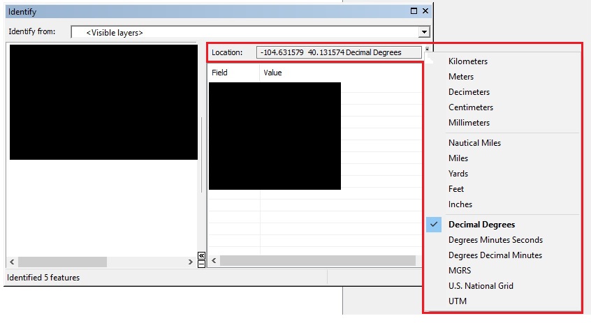
This idea is for ArcGIS Pro and the Measure Features tool found withing the Inquiry Menu. I believe it would be incredible beneficial to add the location units of Latitude & Longitude to this tool, to get a precise Lat/Long measurement of the feature being measured. This idea would be similar to the available procedure in ArcMap where you can use the "Identify" tool to identify a feature, and select the identified feature to display its various location units that you are able to change such as Feet, Yards, Decimal Degrees, etc along with a multitude of other variations of coordinates. So you have the capability of deriving the Lat/Lon from the map for any feature at the exact location of said feature.
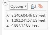
So far I have seen that you can obtain the Lat/Long of a feature from the ArcGIS Pro Explore tool which is the equivalent to the ArcMap Identify tool, but the only way to change the units is to go through at least 4 menus/sub-menus through the "Project" tab at the top left, which of course is not difficult to do, but very inefficient none the less. So using the Explore tool does display the cursor location using Lat/Long but there is potential for a more efficient process, as well as room for more data about the feature to be displayed vs having to use a completely different measure tool to determine what ArcMap displays with one tool.
Also, as a side note, and probably necessary to have an entirely separate "New Idea" post, please allow the Explore tool to use a rectangle to "Identify" multiple features or simply add an Identify tool, rendering the aforementioned idea 'Implemented", otherwise you have to click exactly where the feature is located, most times resulting in being a smidgen off from your desired pointer selection location, or selection a feature that is touching, not a big deal, but just as this ability to post for new ideas to improve ArcGIS Pro is here, it's an idea that would progress the program.
I'll end this post on a humorous acronym spelled out, and with this one, we ALL can rally around 
"Make ArcGIS Great Again"
hahaha ArcGIS is already great I just couldn't resist the humor!
Please up-vote this idea for improving the platform, or at least for my attempt at a funny pun!
- Mark as Read
- Mark as New
- Bookmark
- Permalink
- Report Inappropriate Content
Jerad White Thanks for submitting the idea.
You might be interested in the detailed information provided by the development team in Add a Real Identify tool to the ArcGIS Pro's Inquiry Ribbon Area Look at the July 2nd comment - there's lots of good stuff in there.
I realize that doesn't nullify this idea of having that functionality in Measure Features, but thought that the above info might be helpful.
Also, you can already identify using a rectangle by holding Ctrl and dragging. Hover over the Explore tool to see what you can do with it:
- Mark as Read
- Mark as New
- Bookmark
- Permalink
- Report Inappropriate Content
Thank you, Kory Kramer !
You always find a way to help me, you are seriously knowledgeable about ESRI.
By the way, I tried messaging you directly for assistance on something, but it said I could not message you because we were not connected? Could you and I connect so that I may message you a question? It pertains to moving features to a Lat-Long based off a field.
Best Regards,
Jerad White
- Mark as Read
- Mark as New
- Bookmark
- Permalink
- Report Inappropriate Content
Hi Jerad,
I'm glad that I was able to help. I'd recommend posting your questions to the ArcGIS Pro space as that will open them up to help from the entire GeoNet community. While I love to help when I can, I am one person and we have a very large number of users. Sometimes, I'm just not stretchy enough to help everyone (nor do I have all the answers!) 
So posting to the ArcGIS Pro space is one option. Another option that it looks like you have is using technical support for help.
I hope this helps and I look forward to continuing to interacting on the forums.
Cheers,
Kory
You must be a registered user to add a comment. If you've already registered, sign in. Otherwise, register and sign in.