- Home
- :
- All Communities
- :
- Products
- :
- ArcGIS Workforce
- :
- ArcGIS Workforce Blog
- :
- The Blue Dot: Workforce and Mobile Worker Location
The Blue Dot: Workforce and Mobile Worker Location
- Subscribe to RSS Feed
- Mark as New
- Mark as Read
- Bookmark
- Subscribe
- Printer Friendly Page
- Report Inappropriate Content
Wall-mounted maps have "You are here" bubbles, and our phones use a dot on the map to show current location. But those are clearly not determined the same way: a wall-mounted map always has the same location, while your phone moves about with you. And how your location is determined varies between devices and even app to app on a single device. To best understand the location information presented for mobile workers in Workforce (both our own as a mobile worker, those of other mobile workers, and those of our mobile workers when a dispatcher) we need to understand how location is determined in Workforce.
First, let's understand what the dispatcher is seeing. The location presented for each mobile worker is simply the location the mobile worker's device is passing to Workforce. Once we understand how the mobile device is handling the mobile worker's location, we'll also know how the location the dispatcher is seeing is determined. The only catch is that the location isn't updated for dispatchers continuously; instead, the mobile worker's device updates the mobile worker's current location every minute. This is the location displayed in the web app.
When a mobile worker sees the location of another mobile worker in the same project, their view of that other mobile worker's location aligns with that the dispatcher sees. While they are receiving the same information from the project, it might not exactly match the dispatcher's view. In addition to the offset introduced by mobile workers updating their location with the Workforce project every minute, the mobile worker reading the location is also only checking for updated locations every minute, so the position seen can be up to 2 minutes old.
Now let's look at the mobile worker and their device, as that is the key to all the locations. Workforce uses the location provided by the device's location services. What exactly that means depends on the device and its setup, but what we need to know is that location services determine position information from various sources, such as GPS, cellular, Wi-Fi, and Bluetooth networks. Here is a bit more detail into location services:
- The location reported on the mobile device depends on the information available to the device. If your device doesn't have GPS, it uses a combination of cellular and wireless signals to determine your location. If your device also doesn't have GPS or cellular service, wireless signals are used. GPS generally provides the most accurate locations, after that Wi-Fi, then cellular.
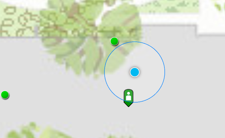
- A more accurate location means that its margin of error is less. Your position might be identical, but if you know you have 10 meter accuracy, you know you are likely within 10 meters of the location shown. If you have 30 meter accuracy, you know you are likely within 30 meters of the position shown. In Workforce, the blue circle around your position indicates the accuracy. In the image below, Workforce believes you are between the tree and the other mobile worker (green pin). However, you might be closer to the green dot, or you might be with the other mobile worker. But it is pretty sure you are inside the bigger blue circle.
- On Android, you can choose a mode for your location (High accuracy, Battery saving, Device only). This changes what is used to calculate location. High accuracy (the default) uses GPS, Wi-Fi, cellular, and other available sensors through Google's Location service to get the highest-accuracy location. Battery saving doesn't use GPS, using only Wi-Fi and cellular through Google's Location service, saving battery. Device only uses only GPS, turning off Google's Location service. Changing this value affects the location you see in the app.
One last thing to understand about location services on iOS: they never provide an accuracy less than 5 meters. Even if you are using an external GPS with sub-meter accuracy, Workforce uses location services and while the position used could be more accurate, the accuracy reported will still be 5 meters, at best. You might notice this if you look at the historical tracks of where mobile workers have been.
A mobile worker will see their position updated continuously. However, as mentioned earlier, they don't update the Workforce project with the same frequency. The project is updated every minute. Additionally, if the mobile worker sets their status to On Break or Not Working, their location is not updated to the project at all until they return to Working. And if the mobile worker didn't set their status to On Break or Not Working before shutting down Workforce, the location the project has for them might be outdated and show them still working.
Got it, you might think. But then you open Collector, and see that your location has better accuracy than you are seeing in Workforce! What is going on here? Well, it actually isn't too complicated: Collector doesn't always use the device's location services, bypassing it for the information coming straight from the location sensor (such as an external GPS). Location services are limited in the accuracy that they'll report, even if the device is getting a better accuracy from the location sensor. Because accuracy is critical in data collection, Collector uses the most accurate information available. Workforce, on the other hand, doesn't have the same requirements, so uses the most easily accessed information.
Now you should understand how Workforce determines the location of mobile workers, what factors contribute to its accuracy, why it might vary between members of the same project, and why it might vary when using other apps. Now when you see worker location and it doesn't seem they are in the right place, yet the workers insist they are, you'll be able to figure out what it is you are actually seeing and how, if necessary to your project, to improve that information.
You must be a registered user to add a comment. If you've already registered, sign in. Otherwise, register and sign in.