Turn on suggestions
Auto-suggest helps you quickly narrow down your search results by suggesting possible matches as you type.
Cancel
- Home
- :
- All Communities
- :
- Services
- :
- Esri Technical Support
- :
- Esri Technical Support Blog
- :
- Regarding Vector Tile Layers and ArcGIS for Server
Regarding Vector Tile Layers and ArcGIS for Server
Subscribe
1512
0
08-19-2016 03:32 AM
- Subscribe to RSS Feed
- Mark as New
- Mark as Read
- Bookmark
- Subscribe
- Printer Friendly Page
- Report Inappropriate Content
08-19-2016
03:32 AM
At Esri, we are always looking to provide you with cutting-edge capabilities that help turn GIS ideas into a powerful reality. One of our newer features is the ability to create, serve, and consume vector tiles, and it is exciting to see users taking advantage of this technology. We would like to take this opportunity to address some of the system requirements needed to implement these services.
As per our Vector tile services documentation, in order to share vector tile layers within your own infrastructure, you will need ArcGIS 10.4 for Server or higher - including the full Web GIS stack. This is comprised of Portal for ArcGIS, a hosting server using ArcGIS Server, and ArcGIS Data Store. To create the vector tiles, you will use ArcGIS Pro 1.2 or higher.
You might ask: Why are ArcGIS Pro and Portal for ArcGIS required to accomplish this task?
ArcGIS Pro offers a robust system of authoring capabilities, which allows content creators to build beautiful maps; and it has the tools to store these maps as vector tile packages for sharing with portals. These vector tile packages are then uploaded and shared through your portal, whether that is ArcGIS Online or Portal for ArcGIS.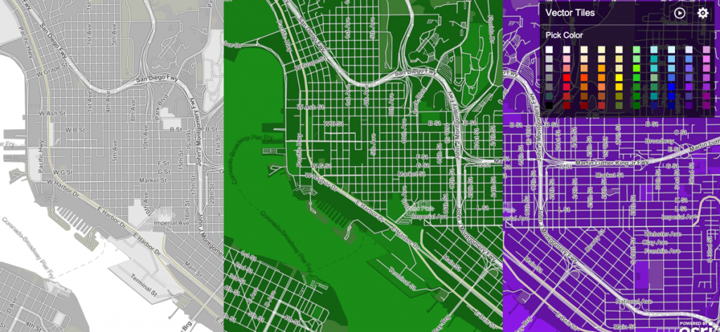
Vector tile layers have unique capabilities. For example, they can be easily restyled with a custom look and feel, which happens dynamically without needing to rebuild the vector tile package. This is possible because Portal for ArcGIS takes advantage of the ArcGIS geoinformation model, which allows you to use, create, and share geographic information throughout your organization, the community, and openly on the web. For ArcGIS Server users who are used to sharing map layers with a portal by registering the REST endpoints as an item, or by creating custom applications directly against those REST endpoints, the geoinformation model provides a more flexible framework whereby geographic information is arranged into map and scene layers. These can be combined to build maps and scenes that can also be used in apps, in analysis, shared with groups, and so on.
To recap, create vector tile layers and vector tile packages using ArcGIS Pro. Share the vector tile packages with Portal for ArcGIS. The portal will automatically unpack the package so that other people can use those vector tile layers in their maps and apps.
Thomas E. - Server Advocacy Lead
As per our Vector tile services documentation, in order to share vector tile layers within your own infrastructure, you will need ArcGIS 10.4 for Server or higher - including the full Web GIS stack. This is comprised of Portal for ArcGIS, a hosting server using ArcGIS Server, and ArcGIS Data Store. To create the vector tiles, you will use ArcGIS Pro 1.2 or higher.
You might ask: Why are ArcGIS Pro and Portal for ArcGIS required to accomplish this task?
ArcGIS Pro offers a robust system of authoring capabilities, which allows content creators to build beautiful maps; and it has the tools to store these maps as vector tile packages for sharing with portals. These vector tile packages are then uploaded and shared through your portal, whether that is ArcGIS Online or Portal for ArcGIS.

Vector tile layers can be restyled without needing to rebuild the vector tile package.
Vector tile layers have unique capabilities. For example, they can be easily restyled with a custom look and feel, which happens dynamically without needing to rebuild the vector tile package. This is possible because Portal for ArcGIS takes advantage of the ArcGIS geoinformation model, which allows you to use, create, and share geographic information throughout your organization, the community, and openly on the web. For ArcGIS Server users who are used to sharing map layers with a portal by registering the REST endpoints as an item, or by creating custom applications directly against those REST endpoints, the geoinformation model provides a more flexible framework whereby geographic information is arranged into map and scene layers. These can be combined to build maps and scenes that can also be used in apps, in analysis, shared with groups, and so on.

The ArcGIS geoinformation model is a framework that lets users easily build informative and compelling maps by pulling different layers together.
To recap, create vector tile layers and vector tile packages using ArcGIS Pro. Share the vector tile packages with Portal for ArcGIS. The portal will automatically unpack the package so that other people can use those vector tile layers in their maps and apps.
Thomas E. - Server Advocacy Lead
Labels
You must be a registered user to add a comment. If you've already registered, sign in. Otherwise, register and sign in.
About the Author
Thomas works on the Customer Experience team at Esri.
Originally from Barbados, his time spent living, studying and working in the Caribbean, Canada, Wales and the U.S. has fueled his love of all things spatial. He is particularly interested in exploring the interconnections between human and physical geographies, and how GIS can be used to tell compelling stories about them. Thomas has been a proud member of Esri since 2013.
Labels
-
Announcements
70 -
ArcGIS Desktop
87 -
ArcGIS Enterprise
43 -
ArcGIS Mobile
7 -
ArcGIS Online
22 -
ArcGIS Pro
14 -
ArcPad
4 -
ArcSDE
16 -
CityEngine
9 -
Geodatabase
25 -
High Priority
9 -
Location Analytics
4 -
People
3 -
Raster
17 -
SDK
29 -
Support
3 -
Support.Esri.com
60
- « Previous
- Next »