Turn on suggestions
Auto-suggest helps you quickly narrow down your search results by suggesting possible matches as you type.
Cancel
- Home
- :
- All Communities
- :
- Services
- :
- Esri Technical Support
- :
- Esri Technical Support Blog
- :
- Is your raster so bright you have to wear shades?
Is your raster so bright you have to wear shades?
Subscribe
1192
0
05-05-2011 11:03 AM
by
Anonymous User
Not applicable
0
0
1,192
- Subscribe to RSS Feed
- Mark as New
- Mark as Read
- Bookmark
- Subscribe
- Printer Friendly Page
- Report Inappropriate Content
05-05-2011
11:03 AM
Have you ever added a raster to an MXD and noticed that it looked different? Or created a mosaic dataset or raster catalog and suddenly, the rasters are so bright, you think, "What did ArcMap do to my raster?!"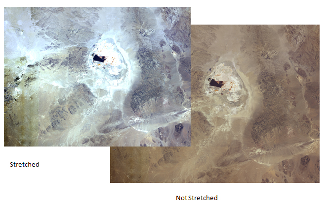
Well, I'll save you a Tech support call. There is a relatively simple reason why your raster is now so bright: there is a "stretch" being applied to the raster, making it brighter. Applying a standard deviation to a raster with statistics is the default behavior in ArcMap because the stretch will improve the display of most rasters, but there are a few situations where the stretch is not appropriate.
In order to turn off the stretch, open up the properties menu of the raster from the table of contents and click Symbology. The dialogue may differ depending on the type of data, but the components are the same. To see if your raster has a stretch, look below the "Display NoData as" button to the section indicated as - you guessed it - Stretch. Under that, you may notice the usual default setting as Standard Deviation. To turn off the stretch, simply switch that setting to "None" and click Apply or OK. Your raster should now look more like the original if you are using a mosaic dataset or raster catalog.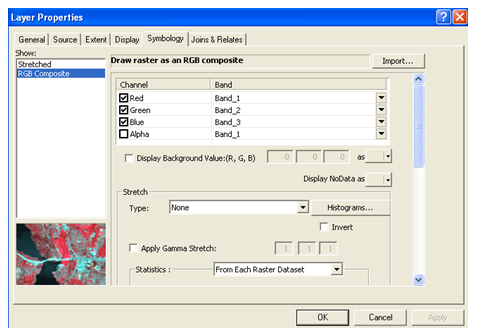
So, why did this happen and where was the setting to control this effect? Well, it depends on the version of ArcGIS Desktop you're using. In ArcMap 9.3.1., the control will be under Tools > Option > Raster > General, titled "Display raster datasets with contrast stretching." Uncheck the box.
In 9.3.1: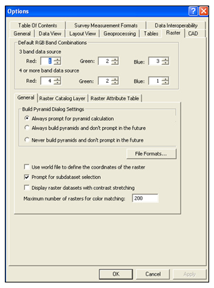
In ArcMap 10, the dialogue will be under Customize > Options > Raster > Raster Layer, titled "Stretch Type". Select None.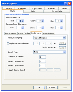
Both of the settings will prevent ArcMap from displaying the rasters with a stretch initially. By default, the stretch is automatically applied to all rasters with statistics added to ArcMap. Deleting the statistics will also prevent the display from being stretched. Related Articles
- KB Article on Sids stretching in an unmanaged raster catalog
- Improving the display of rasters
- Stretching Process in Image Service
- Stretching for Contrast
Labels
You must be a registered user to add a comment. If you've already registered, sign in. Otherwise, register and sign in.
Labels
-
Announcements
70 -
ArcGIS Desktop
87 -
ArcGIS Enterprise
43 -
ArcGIS Mobile
7 -
ArcGIS Online
22 -
ArcGIS Pro
14 -
ArcPad
4 -
ArcSDE
16 -
CityEngine
9 -
Geodatabase
25 -
High Priority
9 -
Location Analytics
4 -
People
3 -
Raster
17 -
SDK
29 -
Support
3 -
Support.Esri.com
60
- « Previous
- Next »