- Home
- :
- All Communities
- :
- Products
- :
- ArcGIS Survey123
- :
- ArcGIS Survey123 Blog
- :
- What's new in Survey123 (August 2020)
What's new in Survey123 (August 2020)
- Subscribe to RSS Feed
- Mark as New
- Mark as Read
- Bookmark
- Subscribe
- Printer Friendly Page
- Report Inappropriate Content
It took longer than we expected, but a new update to Survey123 is now available! This update is part of our 3.10 release cycle, which commenced a few weeks ago with new features introduced in the Survey123 web app, website and report services. If you haven't already, check out the https://community.esri.com/groups/survey123/blog/2020/07/03/what-is-new-in-survey123-july-3-2020 announcement as it covers aspects of the 3.10 release that are not presented in this blog.
We believe you will be excited about the many new things included in this version. Before we start, here is a very quick video with some highlights:
And now for a more detailed discussion.
Streamlined Survey123 deployments
In this update we have bundled a handful of great new features to help you deploy and manage Survey123 more easily within your organization.
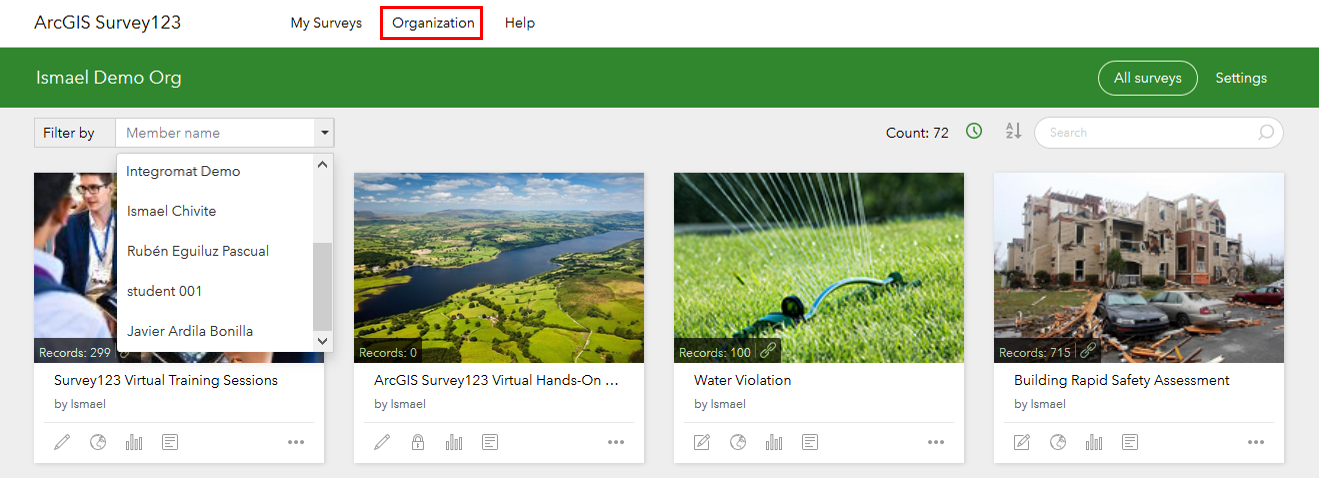
Administrator View in the Survey123 website
When you login into survey123.arcgis.com as a user with ArcGIS administration privileges, you will notice that a new Organization page is available. As an administrator, you have access to all surveys published in your organization. This new Organization page will help you more easily search and manage surveys created by other users. You will be able to filter surveys by owner and use the usual search and sorting options. Once you find the survey you were looking for, you will be able to do all things you, as an admin have been granted privileges to do: change the sharing properties, look at the data, update the survey questions etc.
Survey123 organization settings
Aside from the gallery of surveys within your organization, you will also find a new Settings tab. You can use these organizations settings to define the default behavior of a handful of important things. For example, you can define the group in your ArcGIS organization that sets the collection of basemaps that should be included in the basemap switcher in the Survey123 app. Finally, you can also define the basemap within that group that should be applied by default to all new designs in Survey123 designer and Connect.
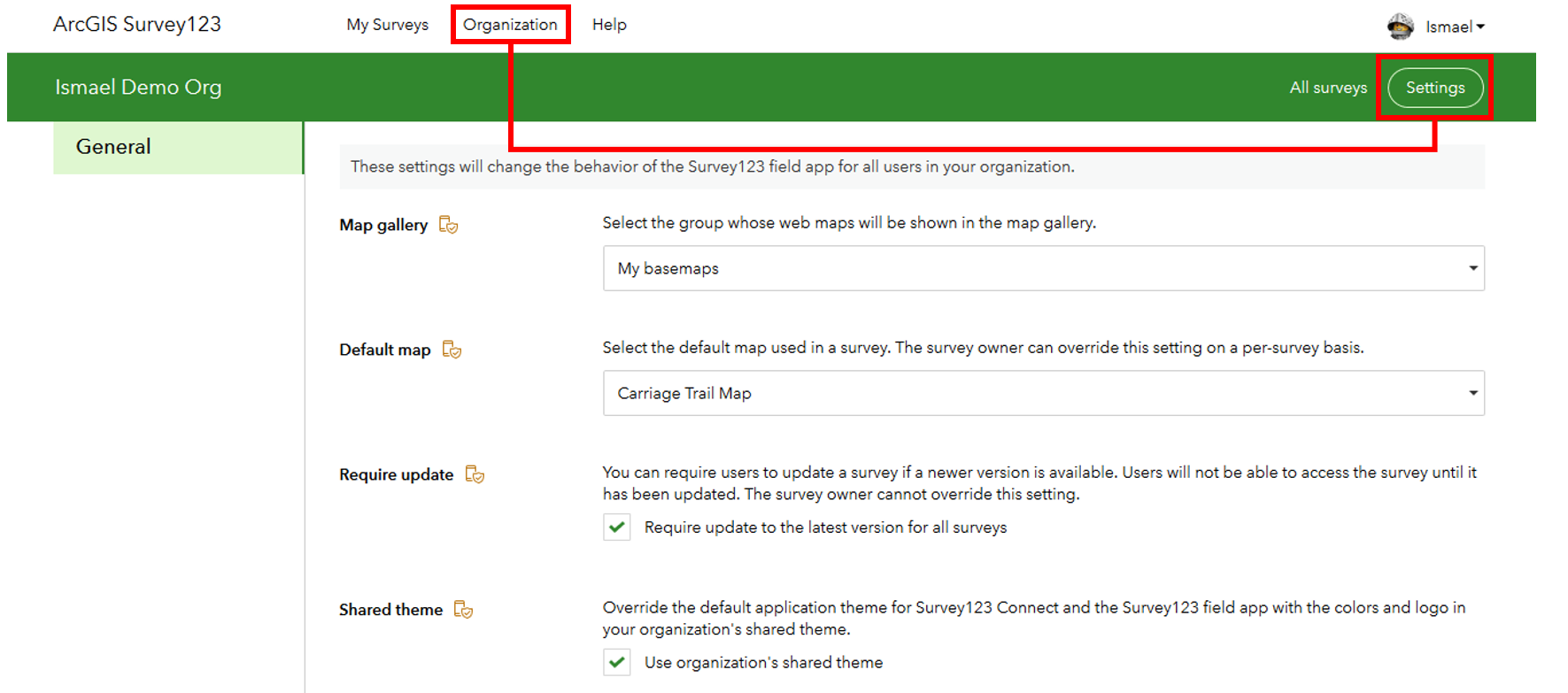
Through an organization setting you can now also require all users of the Survey123 field app to update surveys in their mobile device when a new update is made available. Since this is an organization setting, it will override the 'require survey update' policy set by the owner of the survey from within Survey123 Connect (more on this later).
Survey123 organization settings are a powerful concept, allowing ArcGIS administrators to define certain behavior for survey users and designers. We envision progressively adding more settings over time.
MDM AppConfig support
If you choose to deploy the Survey123 field app through a Mobile Device Management (MDM) solution, you can now define certain behavior of the Survey123 app through the use of AppConfig properties. For example, you can use AppConfig to set the URL of the ArcGIS portal that the app will target by default, streamlining the initial setup of the app by end users. You can also disable certain features in the app, such as the ability to generate diagnostic logs or email data recovery files. Philip Wilson describes all of this nicely in his https://community.esri.com/groups/survey123/blog/2020/08/04/configure-survey123-properties-in-your-m... blog post.
Silent installs of Connect and the Field App
It is not a secret anymore, we can say this out loud  . Both Survey123 Connect as well as the Survey123 field app can now be installed and uninstalled silently (completely silently - no more popups!). Instructions to create your own installation scripts are included in the Unattended uninstall and install help topic.
silent-uninstall-install-ArcGISSurvey123Connect.bat
Survey123ConnectInstallFile.exe
Survey123 website installer update
For those of you who want to deploy a local copy of the Survey123 website and REST API in your own server, we are preparing a Windows installer. This will allow you to deploy Survey123 entirely in your own infrastructure, side by side with ArcGIS Enterprise, allowing you to work in completely disconnected environments. Installing the Survey123 website can also be of interest when working in remote areas with weak internet connection, or when you simply want to minimize external dependencies to better comply with security policies within your organization.
The first version of the Survey123 website installer will be made available in just a couple of weeks.
Better maps for your surveys
With this update, maps look better and most importantly, you can configure your surveys with your own custom maps too.
Better looking basemaps in the Survey123 field app
The Survey123 field app now uses the ArcGIS Runtime map rendering engine. To start, this means that vector basemaps are now supported. As your ArcGIS organization basemap group is likely using vector basemaps, Survey123 will now be able to render them automatically. Vector basemaps deliver a much better experience than traditional raster tiled basemaps. They look crisper on your device, are more lightweight and include labels that rotate to remain readable as you change the direction of your map.
Defining custom maps for your surveys
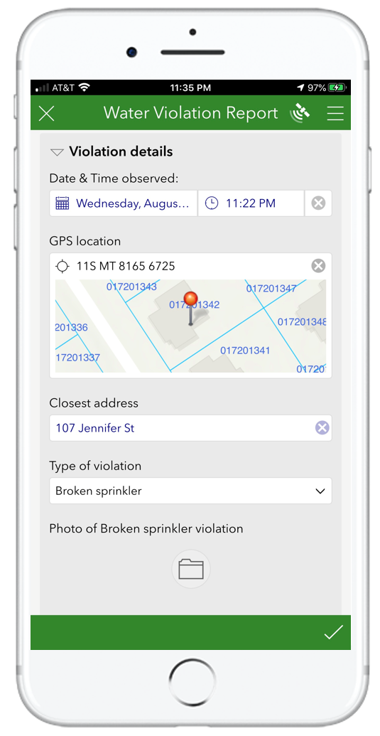
In the screenshot on the right, you can see how the map included in the survey is using a custom web map. It includes the Esri Topographic basemap and a parcel layer with a blue outline and labels on top.
You can now tailor the map shown in your Survey123 smart form so it better fits the workflow at hand. Maps can provide important context to end users while completing the form. Starting with version 3.10, you can easily configure your surveys to use your own web maps, mobile map packages, vector tile packages etc.
As the author of a survey, you can configure your surveys to use your custom map by default, or simply add it into the basemap switcher. This is done through Survey123 Connect, using the new Linked Content dialog.
Custom maps set on your survey are honored in both the Survey123 web app and field* app.
* Note: Android devices with an armv7 architecture and 32 bit operating system are not capable of efficiently rendering ArcGIS vector tiles and offline maps. In these devices, Survey123 will default to standard Esri raster tiled basemaps and not honor custom maps defined in your survey.
Check out the https://community.esri.com/groups/survey123/blog/2020/08/07/survey123-tricks-of-the-trade-configurin... blog for more details.
Better Survey123 folders in the field app
The Survey123 field app models the organization of local survey records similar to how you organize your email. If you have a survey which you have not completed and you are not ready to send, you keep it in the Drafts folder. If your survey is ready to be sent, but your device is disconnected, then it goes into the Outbox. Once a survey is sent, it goes into the Sent folder. Finally, just like in your email, there is a folder for anything that needs attention, the Inbox. The Inbox brings existing records from ArcGIS, so you can open, update and resend them.
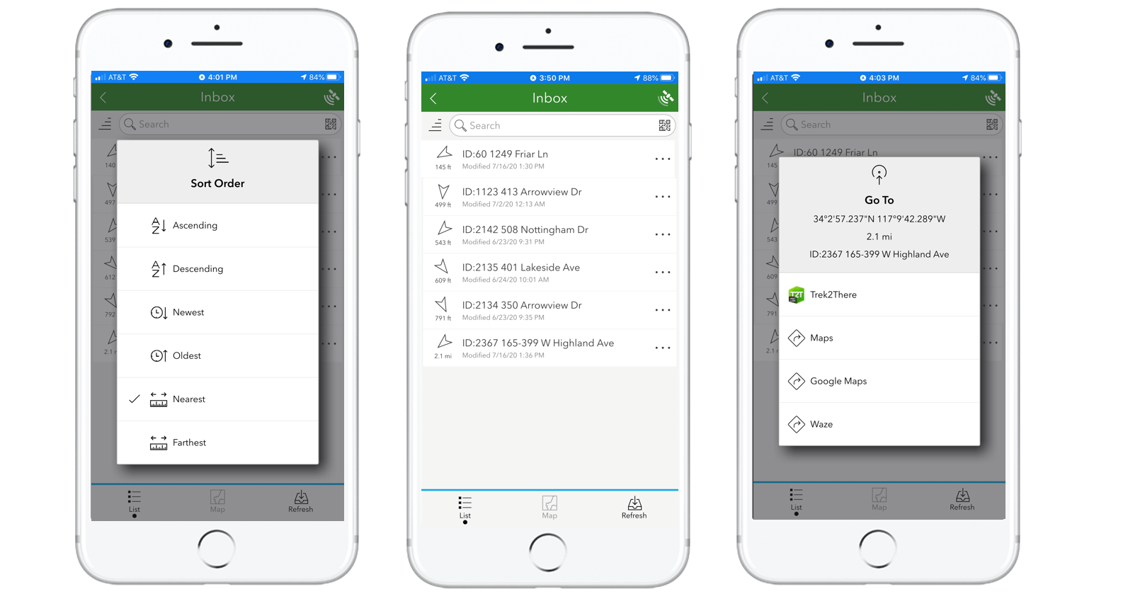
Survey123 records stored in these folders can be displayed as a list and as a map. In this release, the list view helps you more easily sort, search and navigate to the survey records.
- Sorting: Sort alphabetically, by date and by distance to your location.
- Search and filtering: Enhanced with built-in barcode scanning capabilities.
- Navigation: Display distance and direction indicators for each record and link to navigation apps on your device.
The illustration below shows how records in the Inbox can be sorted by distance. If the Inbox is used to list the assets assigned for inspection to the currently signed in user. This option helps promote to the top the assets that are closer to the inspector. The new location indicators are shown in the middle image. The arrow indicates the direction in which the asset can be found, as well as the distance. The direction and distance indicators update every few seconds while the end user is on the move. Finally, a handy shortcut allows users to easily load into third party navigation apps the location of the selected record. This, naturally, includes ArcGIS Navigator.
All these enhancements are particularly useful for routine inspection workflows, where the Inbox is used as a 'to do' list for the day, but the enhancements apply equally to the Drafts, Sent and Outbox as well. The behavior of the Survey123 folders is defined by the author of the survey according to the needs of the business workflow. See the Survey123 Connect section later in this blog for more details.
Better support for attachments: photos (image) and documents (file)
Survey123 has supported working with ArcGIS attachments for quite some time. ArcGIS attachments allow you to associate media (photos, images and documents) with existing GIS records. Survey123 uses ArcGIS attachments to store photos, signatures or drawings sketched from your survey. This release introduces significant enhancements and new features for working with attachments.
One image question, multiple photos
Up until this release, image questions in Survey123 allowed end users to take a single photo. With this limitation, if you needed users to take multiple photos in a survey, either you had to add multiple image questions to the survey or enclose the image question within a repeat. While both approaches worked in some cases, there were drawbacks associated with them. Starting with this update, you can configure an image question to allow multiple photos.
The screenshot below highlights how you can specify, from Survey123 designer, the number of photos that should be submitted with an image question. You can pick a fixed number, or a range.
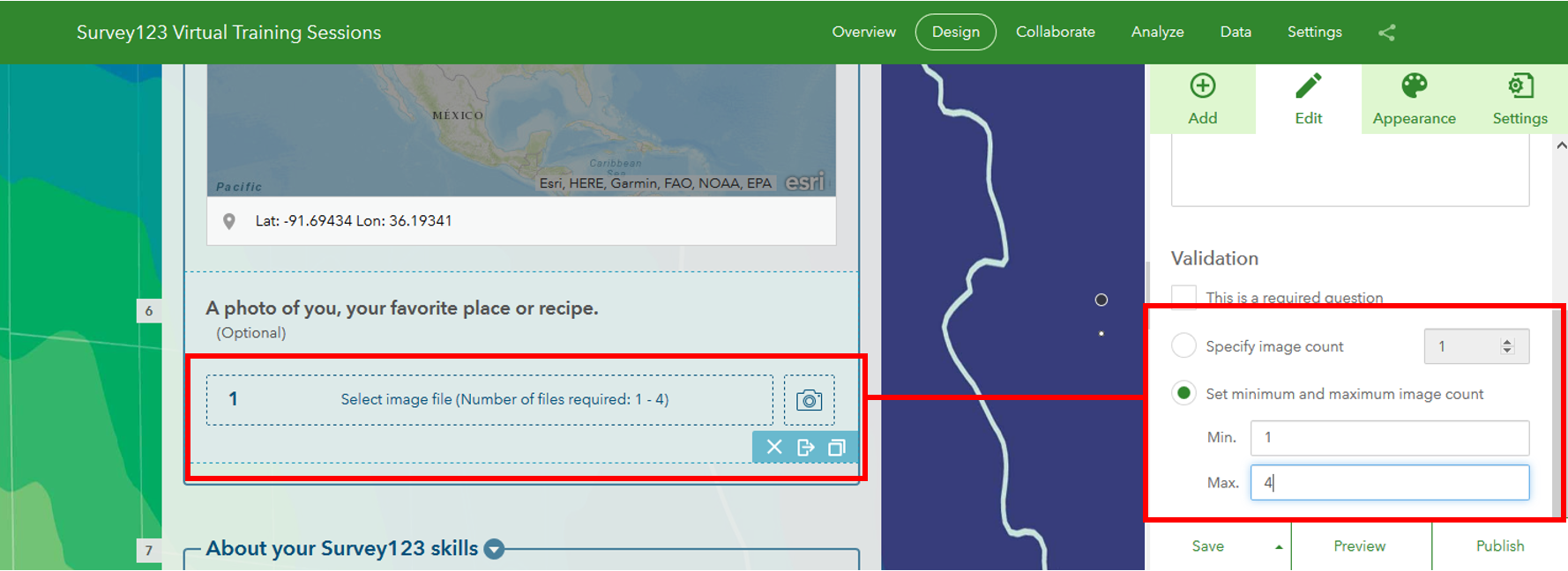
The number of photos that can be submitted from an image question can also be controlled through XLSForm syntax in Survey123 Connect. In its simplest form, you can simply apply the multiline appearance to your image question. Additionally, you can also use the count-selected() function against an image question and it will return the number of photos in it. For a more in-depth discussion on this, check out the https://community.esri.com/groups/survey123/blog/2020/07/30/survey123-tricks-of-the-trade-photos blog post, which explores this in detail. If you have surveys already created with image questions, I bet you may want to make some adjustments in your form after learning about these enhancements.
As you work with the Survey123 field app, you will also notice that the experience to capture and manage photos from your device has changed. We made modifications to streamline the user experience when navigating through captured photos and for rotating and renaming the photos before submission.
Should users take a new photo or will they be allowed to browse for existing ones?
Many of you wanted to have your say on that critical question, and this release will please you. As the author of the survey, you can now use the method parameter in the body::esri:style to control if the image question should allow users to browse for existing photos from the gallery or if the camera should be used instead to take a new photo.

You will find more info about the method parameter in body::esri:style in the https://community.esri.com/groups/survey123/blog/2020/07/30/survey123-tricks-of-the-trade-photos blog post.
File type question
The file question allows end users to upload documents as part of a survey submission. PDF files, word documents, compressed files, etc. The complete list of file formats that you can upload through this question type is limited by the file formats supported by ArcGIS attachments. The complete list can be found at the bottom of the Edit tables—ArcGIS Online Help | Documentation topic.
File formats supported by the Survey123 file question: 7Z, AIF, AVI, BMP, CSV, DOC, DOCX, DOT, ECW, EMF, EPS, GIF, GML, GPKG, GTAR, GZ, IMG, J2K, JP2, JPC, JPE, JPEG, JPF, JPG, JSON, M4A, MDB, MID, MOV, MP2, MP3, MP4, MPA, MPE, MPEG, MPG, MPV2, PDF, PNG, PPT, PPTX, PS, PSD, QT, RA, RAM, RAW, RMI, SID, TAR, TGZ, TIF, TIFF, TXT, VRML, WAV, WMA, WMF, WMV, WPS, XLS, XLSX, XLT, XML, and ZIP.
The file question has been supported in Survey123 designer and the web app for quite some time. In this release we enhanced it to support uploading multiple files into a single question (just like the image question behaves). This release also adds support for the file question type in the Survey123 field app. This means that you can use the field app from Windows to upload local documents through a form, but also from iOS and Android!
Using XLSForm, you can leverage the mutliline appearance and count-selected() function against file questions.
Custom JavaScript functions
In every release we expand Survey123 to model more sophisticated logic via XLSForm. This is important, as XLSForm expressions are useful to create your own calculations, constraints and to model the visibility of questions and groups. With this update, you can invoke your own custom JavaScript logic from the pulldata("@javascript") function. This is relevant because while XLSForm syntax is straight-forward, JavaScript allows you to model logic in ways that XLSForm expressions alone cannot handle. Complementing XLSforms with JavaScript is a winner!
Custom JavaScript functions are configured and published from Survey123 Connect. Using custom JavaScript functions in your smart forms is definitively an advanced workflow, but it is not rocket science. With a basic understanding of JavaScript, there is a lot you can do. You can read more in the https://community.esri.com/groups/survey123/blog/2020/07/16/extending-survey123-smart-forms-with-cus... blog post and the pulldata("@javascript") help topic to learn more about this feature and common use cases for it.
Survey123 Connect
Revised XLSForm templates
Survey123 Connect includes a couple of XLSForm templates to help you start your survey designs from scratch. These templates include a skeleton of the different worksheets and columns used in XLSForm documents as well as built-in tips, validation rules and a few other useful Microsoft Excel tricks to make your life easier.
Consolidating feedback and suggestions made over time, we decided to give these XLSForm templates a revision. They have not changed in a big way, as there was nothing fundamentally wrong with them, but they do incorporate small touches that make them better. To learn more, check out Jim Moore's blog post https://community.esri.com/groups/survey123/blog/2020/08/05/updated-xlsform-templates-for-survey123.
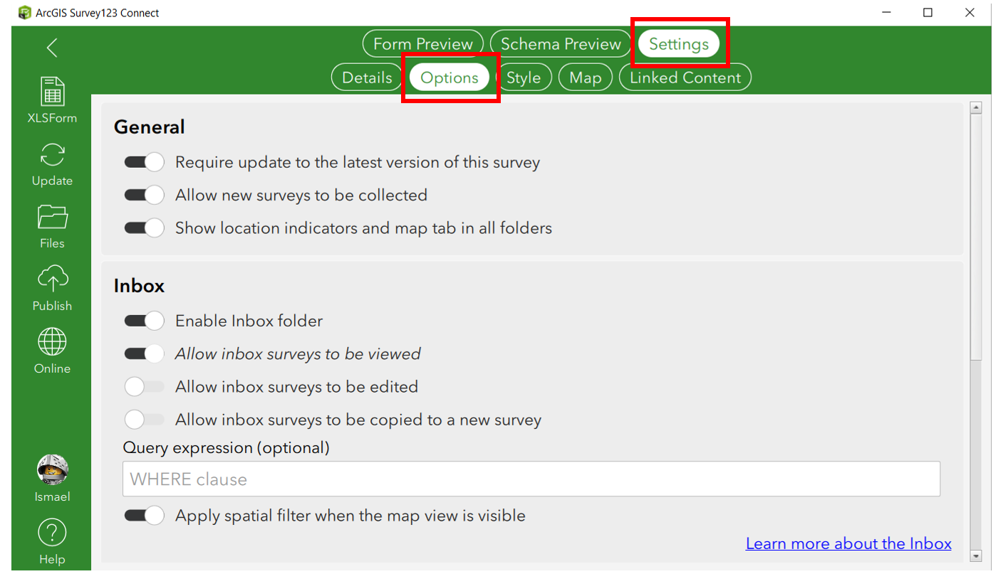
Survey Options
The Settings > Options dialog in Survey123 Connect now helps you better control the behavior of your survey in the field app. This is likely worth an entire blog post on its own. I will highlight here a few of the things you can do:
- Choose as the owner of the survey, if users are required to update their local copy of the survey if you update it.
- Hide the Collect button. This is particularly useful if cases where you want users to always update existing records through the Inbox.
- Show location indicators. This options adds a distance and direction of travel indicator to items in the Draft, Inbox (for editing existing records), Sent and Outbox folders. Location indicators are really useful to help field users navigate to existing records.
- You can also use this dialog to enable the Inbox and Sent folder as well as control the size of images sent from the Survey123 field app and web app.
Other enhancements and fixes
Survey123 Connect and field app
- BUG-000130126 The basemap selected for a geopoint question in Survey123 Connect is not honored when viewing the survey through survey123.arcgis.com.
- BUG-000102606 Creating a Survey in Survey123 Connect for ArcGIS with a period in the Title results in two broken surveys being created.
- BUG-000126810 The EXIF Sample Form in the Survey123 field app and the Survey123 Connect does not succeed in pulling the latitude and longitude of photos taken on Arrows F-04K and Arrows F-01K devices.
- BUG-000103458 Survey123 for ArcGIS custom URL schemes do not include support callback parameters such as http://x-callback-url.com.
- BUG-000095706 Unable to create a new survey or sign in using the Ubuntu version of Survey123 for ArcGIS app.
- BUG-000131096 Incorrect spelling for settings in Survey123 in Portuguese OS
- BUG-000125110 Basemaps do not display as expected for all scales when a survey is re-downloaded to a device after imagery updates.
- BUG-000129238 Survey123 Connect for ArcGIS does not recognize the decimal numbers if the Windows language settings is in Portuguese (Brazil).
- BUG-000124917 In Survey123 3.5 app for mobile devices, the geopoint question Default Map View button does not return the map extent to the designated default location and instead shows the null point in the Atlantic Ocean.
- BUG-000113973 When accessing a publicly available survey published to Portal for ArcGIS using the Survey123 for ArcGIS app, if the portal connection is not configured in the app, the survey is inaccessible with the following error message, "Survey ID is not found."
- BUG-000105957 Deleting a side loaded basemap (TPK file) using the Map Library within a Survey123 for ArcGIS app does not remove the TPK from an Android device.
- BUG-000128449 Unable to view a web map published from Survey123 Connect for ArcGIS built from an existing feature service.
- BUG-000132191 Please add directions in the description section of this 'Download Survey123 Data' item.
- BUG-000132196 The documentation for Survey123, "Prepare for editing existing survey data" still shows information about using Non-Standardize Queries.
- BUG-000131615 The linked content web maps no longer appear in the basemaps list for geopoint questions when opening in ArcGIS Survey123 field app V3.9.149.
- BUG-000132302 Unable to add multiple images in ArcGIS Survey123 mobile app (iOS) in a survey that was created with ArcGIS Survey123 Web Designer.
- ENH-000123885 Improve the process of capturing and sending Diagnostic Log files in the Survey123 for ArcGIS Field App.
- ENH-000107685 The Survey123 for ArcGIS field app should allow different file formats as attachments while submitting form data
- ENH-000130703 Allow Survey123 to integrate with other apps using Universal links
- ENH-000118156 Allow for image attachments to be submitted through a webhook.
- ENH-000123510 Send related record information to webhook providers
- ENH-000131457 Ability to view photos taken with Survey123 on iOS and Android devices.
- ENH-000115447 The Survey123 field app should search all internal storage locations for photos on Android devices
- ENH-000130402 Provide the ability to submit multiple images from a mobile device in one form when submitting survey
- ENH-000127042 Add ability to organize or filter downloaded surveys in the field app
- ENH-000123765 Allow the Collect option to be disabled for users in Survey123 field app
- ENH-000116753 Allow disable the upload image from device's files in survey 123
- ENH-000116357 With Survey123 for ArcGIS, allow barcodes to be used to search for existing features in the Inbox
- ENH-000105321 In Survey123 for ArcGIS application, user would like to request for the copy and edit survey feature to be placed under the 'Inbox' folder/feature instead of 'Sent' folder/feature.
- ENH-000127282 Enhance the performance with Survey123 barcode scanner to include a greater ability to read codes other than black and white
- ENH-000129448 Please provide documentation that demonstrates accessibility workflows across the ArcGIS Survey123 platform.
- ENH-000130111 Provide the ability to run the silent installation completely silent without showing install or uninstall progress pop-up.
- ENH-000122295 Close/Return to initial Application on submission when survey is launched from Custom URL
- ENH-000107611 Provide the option for a Survey123 survey called outside of the application with the 'arcgis-survey123://?itemID=' Custom URL Scheme to open the 'Inbox' menu by default instead of the 'Collect' menu
- ENH-000109445 Implement the ability to utilize a secured service as an online basemap in Survey123
- ENH-000114786 Add ability to customize the map shown in the Geopoint question form in Survey123 for ArcGIS, either by choosing a custom Web Map or by adding boundary datasets within the default map.
- ENH-000113866 Survey123 field app: add support for PortalURL property via Mobile Device Management (MDM) configuration to set default portal
- ENH-000111185 Provide the ability to view feature layers as operational layers in a map in Survey123.
- ENH-000107257 Display results of a survey submission in the map view of the Survey123 Field app when geopoint locations that were collected are a part of a repeat question.
- ENH-000126047 The List and Map views are not available on the Sent page of the Survey123 for ArcGIS field app when a survey has a geopoint question within a repeat.
- BUG-000132618 An error message, "ERR_TUNNEL_CONNECTION_FAILED" is returned when signing in to the ArcGIS Survey123 field app after removing a previous Portal for ArcGIS connection that utilized SAML authentication.
Survey123 website, web app, report services, Integromat and Microsoft Automate connectors
- The list of BUG and ENH addressed is available at: https://community.esri.com/groups/survey123/blog/2020/07/03/what-is-new-in-survey123-july-3-2020
Next steps
We will be watching closely GeoNet and and the Esri Technical Support queue in case any adjustments are needed to this update. We have made quite a lot of changes and have added lots of new functionality, so we are not ruling out some focused patches. While this is ongoing, you will see before the end of August the release of the Survey123 website installer for Windows. On top of this, a Beta version of 3.11 should be made available for testing in late August or early September through the Survey123 Early Adopter Community website as well.
You must be a registered user to add a comment. If you've already registered, sign in. Otherwise, register and sign in.