- Home
- :
- All Communities
- :
- Products
- :
- Imagery and Remote Sensing
- :
- Imagery Blog
- :
- Drone2Map for ArcGIS version 2.1 is now available
Drone2Map for ArcGIS version 2.1 is now available
- Subscribe to RSS Feed
- Mark as New
- Mark as Read
- Bookmark
- Subscribe
- Printer Friendly Page
- Report Inappropriate Content
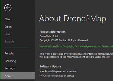
Drone2Map version 2.1 is now available. Current users can view “About” in the main menu on the left side of the screen to verify your version, and download a new version if necessary. You can also download from My Esri.
What’s new in Drone2Map for ArcGIS version 2.1?
In this release we continue to improve the user experience in many areas of the workflow.
Camera Model Editor
- Esri maintains an internal camera database which is updated along with Drone2Map several times per year. In addition to the internal camera database, Drone2Map also has a user camera database. With the Camera Model Editor, users are now able to edit existing cameras from the internal camera database and store the modified camera models in the user camera database.

- An important use case supported by this capability is to provide support for high quality metric cameras, where the photogrammetric lens parameters such as focal length, principal point and distortion are stable and known. Since Drone2Map supports consumer cameras, these parameters may (by default) be adjusted during processing. For metric cameras, the Camera Model Editor allows users to input known, high accuracy parameters when applicable and maintain those values throughout processing.

- Additionally, when a successful project has been processed and you are happy with the results, the .d2mx file from that project may be imported into the camera model editor of a new project and those optimized camera parameters from the imported project will be stored in the user camera database and allow those parameters to be used in future processing jobs. This helps to standardize results and reduce processing times.
Control Updates
- In this release there is an improved user experience for managing control using the Control Manager. Users can view properties of each control point, filter based on the type of control, and launch the links editor, all with a few button clicks.
- Some geographic features, such as water, can be difficult to generate sufficient tie points and successfully match those tie points using automated algorithms. Now users can create and link manual tie points to images to successfully process imagery in geographic areas that previously caused problems.

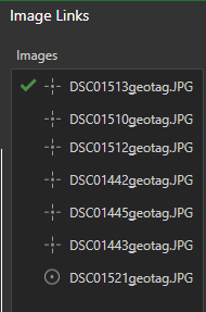
- Linking control to your images can be a time-consuming process. At Drone2Map 2.1, we have introduced assisted image links. This workflow requires initial processing to be run, and after you enter one link, the software is able to automatically find your control markers in subsequent images and provide visual feedback as to the accuracy of that link. Once satisfied with the positioning of the control to the images, simply click Auto Link and Drone2Map will link the verified control for you.
Share DEM as Elevation Layer
- Drone2Map users are now able to publish their own custom surfaces on ArcGIS Online or ArcGIS Portal for either an ortho reference DTM or top surface DSM. These surfaces can be used in 3D web scenes to ensure accurate height values for point clouds and meshes generated by Drone2Map.

Add custom DEM into the Drone2Map project
- Users may add their own elevation surface into the project (on top of the default World Terrain surface), to ensure that any 3D views incorporate the authoritative elevation surface. This can be very useful in project areas that are captured on multiple dates (e.g. agriculture) and/or where an accurate input terrain is important (e.g. an airport, construction site, or a site with material stockpiles).

- In addition, if ground control points are subsequently extracted from the map, the Z values are provided by the custom elevation surface. This is important to ensure date-to-date consistency for sites that are captured repeatedly and analyzed over time.
Elevation Profile and Spectral Profile for additional analytical capabilities
- Users are now able to generate cross-sectional elevation profiles in any Drone2Map projects that are processed to create output surfaces (DSM and/or DTM).
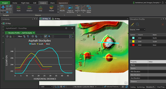
Imagery provided by GeoCue Group, Inc.
- For users with multispectral cameras, Drone2Map also allows extraction of spectral profiles (defined by point samples, linear transects, or 2D areas of interest) to support detailed analysis of vegetation or other landcover surface types.

Colorized Indices
- Indices created from multispectral imagery products are now colorized by default.
New Inspection Template
- The inspection template has been added to all users who wish to create projects that are focused on inspecting, annotating, and sharing raw drone images.

Browse performance improvements
- Performance has been improved when browsing folders and files on disk.
Exif reader improvements
- The performance of reading and extracting Exif data from drone images has improved to significantly reduce the amount of time required to create a project.
Licensing Changes
- Drone2Map for ArcGIS 2.1 is a “premium app” which is a for-fee add-on to ArcGIS Online or ArcGIS Enterprise.
Full release notes for Drone2Map 2.1 are available here
You must be a registered user to add a comment. If you've already registered, sign in. Otherwise, register and sign in.
-
Analysis
10 -
ArcGIS Drone2Map
3 -
ArcGIS Excalibur
1 -
ArcGIS Image Analyst
1 -
ArcGIS Image for ArcGIS Online
1 -
ArcGIS Pro
1 -
Change detection
1 -
Deep learning
4 -
Elevation and lidar
8 -
Image classification
1 -
Image management
2 -
Image Mapping
8 -
Image Services
3 -
Mosaic datasets
4 -
Motion imagery
10 -
Multidimensional
2 -
Oriented Imagery
2 -
Raster functions
4 -
Site Scan for ArcGIS
1 -
Visualization
9
- « Previous
- Next »