- Home
- :
- All Communities
- :
- User Groups
- :
- Conservation GIS
- :
- Blog
- :
- Tendai "Tee" Anna Nekatambe, Zimbabwe
Tendai "Tee" Anna Nekatambe, Zimbabwe
- Subscribe to RSS Feed
- Mark as New
- Mark as Read
- Bookmark
- Subscribe
- Printer Friendly Page
- Report Inappropriate Content
Navigation: 2018 Scholar Project ReferenceProject CommunitiesPage ConservationGIS Scgis.org
Tendai “Tee” Anna Nekatambe, Head Of Dept of Wildlife Management, Don Bosco Tech College,
P O Box 270, Hwange, Zimbabwe

(Scgis Years: yr18 )
*-Main email: dbtcprojecthwange@gmail.com
URL: http://dbtchwange.strikingly.com/
Skype etc: (Watsapp – 00263779035263). (Skype – tendai.nekatambe)
email: teenecqaz@gmail.com
Don Bosco Technical College It is set to be the largest technical institution of its kind in the largest province of the country, Matabeleland North. The College was established in 2007 and is a lawfully registered Tertiary Institution located in the mining town of Hwange. Hwange Town is located 100kms away from the Victoria Falls. This region is a region that is abundant in natural resources and teems with a large biodiversity system. The backbone of the region is based mostly on the extractive industry in the form of mining and other such artisanal activities. Hence the college seeks to invest in young people and improve their livelihoods by offering quality tertiary education, skills development and employment. The college is duly registered under the Higher Education Examination Council (HEXCO) and since the inception of the College; the Centre has produced hundreds of graduates even with minimal infrastructure. Don Bosco Technical College in Hwange is only one of over 5000 such institutions found across the globe that have been formed by the Salesians of Don Bosco. The Salesians of Don Bosco are made up of Roman Catholic Priests, Sisters (Nun), Missionaries and Lay people (also called co-operators) who dedicate themselves towards the holistic formation of young people with education and spiritual formation being at the forefront of their work. Their collective mission is to groom ‘ Good Christians and Skillful Citizens’. Our standing motto is that ‘Education is a matter of the heart’ and is also in the collective interests of various stakeholders at large. The current list of courses on offer includes Information Technology, Clothing Technology, Brick and Block laying, Business Studies and Wildlife Management
Last year the College officially launched a USD $ 3.272 million project to expand the current infrastructure and incorporate more technical courses that require specialized facilities and workshops. The College is looking to invest into building infrastructure that will be beneficial to the context within the Hwange Community. Hwange District is the largest district in the country and has 4 of the countries 10 National parks as well as conservancies and hunting concessions. The district also contains 3 of the largest and most productive natural hard wood forests. Therefore the college hopes to expand the institution to fully create a fully equipped Faculty of Natural Resource Management with appropriate lab and computer facilities for all learners. This project is the first of its nature within the province and hopefully young people may through the institution receive practical skills to give them a competitive edge in industry. The College will also be there to serve those in the community who are already in industry and are looking to advance their current skill sets. GIS skills are beginning to be much sort after not only by those in Conservation but also those in mining and surveying. The current catchment area of the institution its self is very wide, extending to remote rural areas as over 50% of our graduates have received full tuition scholarships given by the College. The College over the last few years has reached out to Catholic Missions in remote rural areas to offer these scholarships and students have done exceedingly well in their examinations. It is hoped that with the expansion of the institution more and more young men and women may receive such opportunities. The Current Department of Wildlife Management was opened last year with our first intake having completed their base level or Foundation Certificate course. The course its self was well subscribed and the students who leave institution can be fully employed in local anti-poaching Units and as rangers in National Parks and other protected areas.
Our institution also has a youth and Oratory Centre for young children in the local high-density residential area to come and play games, do homework, learn music and receive Christian-Formation.
My current role in the organization is that of Head of Department of Wildlife Management. This department will be one of other departments that will form a fully functional Faculty of Natural Resources in the near future. My role is to equip the learners with the theoretical and practical knowledge required for their respective course levels. I lecture and set up practicals from which I test their understanding. I also am responsible for setting up four to six week placements during their two vacation breaks in the year with the various wildlife and conservation based institutions in the area. These practicals are useful in that upon completion of their respective courses some have the opportunity to go back and continue on voluntary basis whilst they seek more permanent employment. I also am responsible for teaching tutorials for those with a keen interest in pursuing Tour guiding learner permits that are issued after examination by the Parks and Wildlife Management Authority. I am also a regional examiner for the Higher Education Examination Council (HEXCO) examinations. I am also responsible for looking for ways to expand the skills offered in the course and this often pushes me to research and learn new skills to teach my learners.
*-HISTORY: My very first Conservation Internship was carried out in South Africa at an organization called VulPro (Vulture programme) where we carried out capture and release operations that involved the fitting of GPS/GSM tracking devices and tags on Cape Griffons and African White back Vultures. The Facility was built mostly rehabilitate-injured Cape Griffons and also resuscitates their numbers in the region, as they are Southern Africa’s only Endemic Species of Vulture. Therefore although the species is still extant within the region breeding colonies have become extirpated in certain Countries such as Zimbabwe. This is where I got to learn how Google map could be used to display information pertaining to movement and also that, which pertains to breeding areas. We also used to collect spatial data on all breeding colonies found in South Africa every year to update into a database. While I was there I was able to work closely with my then internship supervisor who demonstrated to me these techniques. We also used it to map access to food and nesting availability (for colony monitoring) as well as the occurrences of poaching incidents.
In 2013 I applied to Painted Dog Conservation (PDC Zimbabwe) where I started off as a volunteer in the research department for a period of six month. After this time I was then placed on a WCN Scholarship for another six months under still under the research Department that was headed by Dr Greg Rasmussen at the time. I also obtained practical experience in learning to create, manage and update accession databases for data collected on faecal samples in order to map the occurrences of various endoparasites found in African Painted Dogs across the Northern region of Zimbabwe spanning the entire Zambezi Catchment area. I was fortunate enough to have learnt through the guidance of my current SCGIS mentor Tatenda Muchopa with whom I worked closely with at the time at PDC some of the principal fundamentals of GIS using the Quantum GIS software. She would with great detail demonstrate practically how GPS collar data, den site location data and tourist siting data could be transposed on to a map to vastly increase our chances in locating and monitoring the movement of packs within our study area. She also would show me how she meticulously geo-referenced maps for use in our work. Through these practicals, I was able to familiarize with terms such as vector and raster data or files and I learnt not only how maps are geo-referenced but also the fundamental reason why.
In 2014 the research team moved to Victoria Falls to begin the Painted Dog Research Trust, still headed by Dr Greg Rasmussen. This research based Trust is located just outside the town of Victoria falls nestled in a rural community that is still learning to cohabit with the local wildlife in the area. Here we where able to make use of the georeferenced maps made by Ms Muchopa as we continued our research work in this new area. An interesting facet to the conservation work we were carrying out included working with communities who would provide us with sighting of the Painted dogs and from whom we collected much information on Human-wildlife Conflict incidences. This is currently the thrust of my Master o f Philosophy research thesis where I am examining the footprint characteristics of several sympatric carnivore species in order to develop and refine a footprint Identification technique that can be used in communal areas to f\determine the true perpetrators of depredation.
I have also been involved in the drafting of the very first Action plan for Vultures in Zimbabwe. This was an exciting opportunity where I was able to contribute through various workshops held by Bird life towards a comprehensive plan to tackle the threats to vultures and help resuscitate breeding colonies that no longer existed any more. I am also a member of the Gwaai farmers’ conservancy. On our family farm we have been able to mobilise a group of local women from a near-by community to cut and harvest thatching grass for sale and for their own household renovations. This helps protect our ecosystem from veld fires and also provides a much-needed source of revenue.
Local SCGIS work: I am currently not apart of any SCGIS chapter although I am part of a group of environmentalists called the environmental platform and from there I have been able to access resources on GIS. This platform is not solely for the purposes of GIS but it is made up of a number of conservation and environmental professionals who are passionate about sharing knowledge and also figuring out ways to apply it. It has members from all over the country and is gaining regional membership rapidly.
Local Community work: I currently have one-year experience in a formal teaching set up with a curriculum for wildlife management at Don Bosco Technical College. Through this I have been able to also learn how to develop my own curricula for the other short courses I teach for those siting for the learner Professional Tour guiding permits permits.
I am also the President of my Community Rotaract Club (part of Rotary International, District 9210) and we held a cleanup campaign last year in the CBD of local community in conjunction with the Environmental Management Authority (EMA) and local businesses managers and their employees and stakeholders as well as a number of community volunteers. This was part of a National Campaign for Zero tolerance to litter and our theme was ‘It takes a community’. We also did education and awareness during the event through teaching the public about the importance of keeping the environment clean.
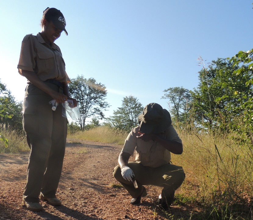
GIS work: I am currently learning GIS through access to self-teaching manuals and notes obtained from colleagues in the field of conservation. I also use YouTube tutorials to help me refine my skills. I currently enrolled to start on the 1st of January for an online course on the fundamentals of GIS with Coursera that was created by the University of California Davis and is taught by Nick Santos and I hope to share this course with others. Through my Masters in Philosophy research project, I hope to get to learn more about GIS applications through the use of JMP Statistical Package, as I become more familiar with it this year in the course of my work. It has been used in non-invasive species monitoring particularly with footprint analysis, which is the main thrust of my Masters research. I am also learning how to use R and I hope to venture deeper into the GIS applications of the software. With regards to GIS, my mapping skills are currently very limited mostly due to the lack of appropriate software and other inputs such as shape files to practice on. I have been fortunate however to have had various opportunities to be able to see the vast possibilities that come with learning skills in GIS, both practically in the field through fitting collars, using hand-held GPS’s obtain loc-stats and map reading. This is the current knowledge that I am transferring in my capacity as a lecturer my local community college to students hoping to venture in the field of wildlife management. In high school I specialized in geography among other subjects and I also offer tutoring courses to exam candidates.

What is the most challenging about the conservation/GIS work that you do? I consider myself quite fortunate to be in the line of work that I am in. When I began teaching I quickly realized that I could not impose a curricula on my students, because they already had acquired a repository of information with regards to how they perceived their natural environment and the animals that inhabited it. I almost had to as for permission as it where to populate their minds with concepts and facts to help them have a correct understanding of all that they had observed, had been told and what they had assumed. I was able to explore some of their own ideas through open class discussions where I found myself learning new things, each one with their own narrative. Some of the new discoveries I made from my open discussions with them were with out a doubt true, based on culture and superstition or just plane assumptions. Most often I am the teacher in the class but I always get the opportunity to walk away with nuggets of information.
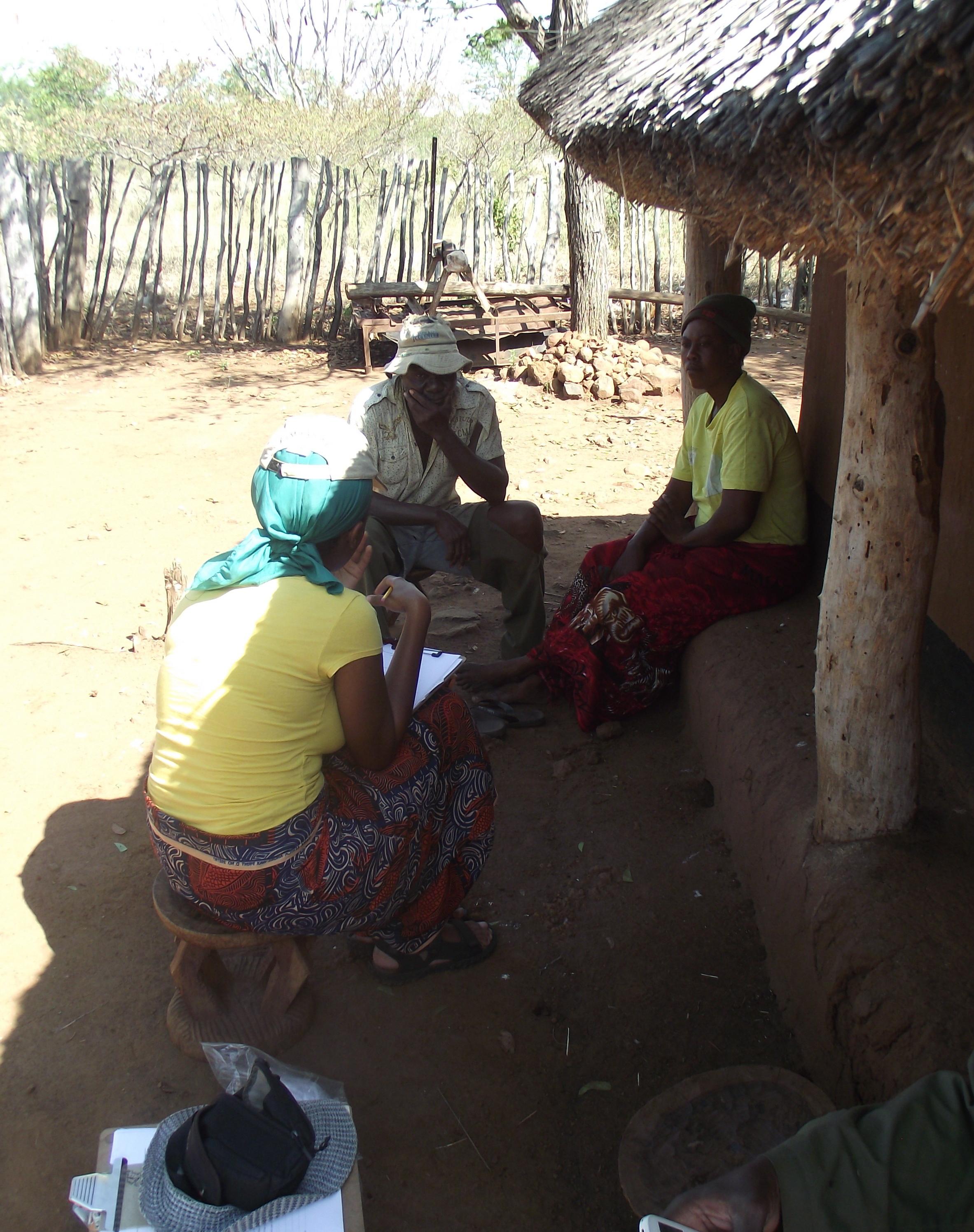
I live in a community that is culturally diverse with over 8 minority cultures in the region alone. Each of these cultures has their own way of interpreting the local biosphere. And there is so much to learn from the different cultural perspectives but alas this information is dying away. I have learnt that for conservation education to be effective in the community it should be reinforced with local knowledge. I feel this is a challenge and ultimately dilutes the efficacy of carrying out education and extension work as a whole. Conservation education should be participatory to be fully effective and engaging. I remember carrying out a participatory mapping exercise in a community based outside Hwange National Park, The country’s largest protected area. It was done with both men and women and it was a beautiful example to see how detailed their spatial knowledge was especially as they began to add layers upon layers such as water points, grazing areas, fire sensitive areas and depredation areas. In such a scenario one would build upon such knowledge and take it to the next level. A lot of these local communities are within cellphone range and there is an increasing number with smartphones. If taught well people can be taught how to relay and analyse spatial data for representation purposes and assist local Forestry and Wildlife Authorities.
Plan for the next year:
Overall Plan: To be able to teach mapping skills to students enrolled at Don Bosco Technical College, Rangers, Anti-poachers, NGO’s, Conservation groups, Environmentalists as well as other professionals in industry in order to fill the knowledge Gap that currently exists in the Province.
Objectives:
To design comprehensive curricula that will cater to the different needs of the participants.
Collaborate
To load relevant soft wares in the already functional computer lab at Don Bosco College
Objective | Duration | Expected outputs |
To design comprehensive curricula that will cater to the different needs of the participants. Collaborate. Submission of proposal for formal approval
| 1 Month | Curriculum Approved at Monthly Academic board meeting |
Hold 2 strategic training workshops (During student vacation period) targeted at rangers as well as community based Anti poaching teams.
Carry out practical’s on data acquisition, map reading as well as loading the data into ArcGIS to represent data on maps | 2 months | Povide local anti-poachers and rangers with a unique opportunity to be able to learn the fundamentals of GIS and its applications.
Participants will also get to refine their skills in data aquisistion. |
Carry out two workshops based in the communities to convey results of GIS study and obtain feedback and wayforward. | 2 months |
|
Data collection and analysis on cases of livestock depredation in the Two study areas | Ongoing | Clearly represent the areas mostly affected by Livestock depredation |
Commencement of initial GIS training/ Fundamentals of GIS to students including data collection techniques using GPS
| On going | Students to not only familiarize with GIS work but data collection and map reading |
2018 Title & Abstract of the paper you will present:
"Using Footprint Analysis as a forensic too in the mitigation of Human-wildlife-conflict: African Painted Dog and sympatric species."
According to Jewell et al. (2001), spoor identification by tracking is an age-old technique, still practised by many indigenous peoples for hunting and interpreting animal behaviour. Animals that leave tracks in suitable substrate produce potentially valuable data (e.g. regarding density, location, movement), which can be exploited for the identification of reclusive, nocturnal species from their footprints and this promises to be a non-invasive, cost-effective, technique for monitoring and research. (Stander & Ghau, 1997; Law et al., 2012).
Many carnivore species are wide-ranging, solitary, nocturnal and occur at low densities, thus making it hard to obtain reliable population estimates (Balmeet al., 2007). However, footprints are more readily available and serve to more reliably mitigate these issues. As such over the years, tracks have been used in carnivore studies mostly in the estimation of relative abundances and although very useful, the accurate detection of tracks can be a challenge even for the most experienced professional (Law et al., 2013). Furthermore based on “expert opinion”, certain species have been declared extant for decades when in fact they have been extirpated (Croes et al., 2012). Footprint identification provides a much-needed layer of information that can be used to establish the range and distribution of animals over a wide-ranging area (Law et al., 2013).
However, although many carnivore footprints appear similar, there are distinct morphological differences or ‘characters’ that have emerged as a result of evolution and can facilitate rigorous identification. Population estimates are an important function in the field of ecology and wildlife conservation and are required to formulate conservation strategies, prioritise the allocation of resources and evaluate the success of conservation (Sharma & Wright, 2005).The differing attitudes of agriculturalists and conservationists to problem animals and their management, especially where larger predators are involved has resulted in the development of human-wildlife conflict. Consequently human-wildlife conflict has been identified as one of the major threats to conservation, and one of the most difficult problems that conservationists face (Hill et al., 2002). The anthropogenic alteration of carnivore habitats has escalated these conflicts (Treves & Karanth, 2003) and as a result there lies great potential in attempting to establish the true perpetrators of human-wildlife conflict based on footprint analysis.
Other possible methods would include examining the carcasses for traces of salivary DNA, collecting faecal DNA, studying the physical characteristics of fresh faecal samples from the perpetrator as well as looking into the manner in which the livestock was killed and fed on. Although the aforementioned techniques can be implemented, this study seeks to showcase the robustness, accuracy as well as speed and applicability of footprint analysis in a rural setting. Such a system can be used in the field as a forensic tool to determine the true culprits of livestock depredation and assist in mitigating the conflict.
xEducation xWildlife xMammal xTracking x2018Scholar x2018Talk xScholar xTalk xZimbabwe xPOC xWomen xAfrica
You must be a registered user to add a comment. If you've already registered, sign in. Otherwise, register and sign in.