Ela Šegina, Slovenia
- Subscribe to RSS Feed
- Mark as New
- Mark as Read
- Bookmark
- Subscribe
- Printer Friendly Page
- Report Inappropriate Content


Ela Šegina
 Geological Survey of Slovenia
( xTTT2019 x2019TTT xScholar2013 xTTT2013 x2013Talk xSlovenia xChapter xGeology xLandslide )
Researchgate Profile SCGIS Slovenia Chapter
Dimiceva 14, 1000 Ljubljana, Slovenia, 00386
ela.segina at geo-zs.si
2019 Profile: Ela is a participant in the first-ever SCGIS TTT Summit Meeting.
2019 International Conference Presentation
2019 Map Gallery Interviewer TEAM MAPITAS
2013 TTT Certification: Ela received her TTT Trainer Certification in Sept 2013 at the "Second National "Conference of the Community Environmental Conservation GIS" Conference, organized by the SCGIS Russia Chapter.
Arcnews Article about the 2013 Scgis Russia TTT'"The three former Scholars recently trained in Russia are now ready to teach the AE class, both in terms of their skills and having the material. As they gain experience and confidence, they will add more classes to their repertoire, with the continuing support of Juniper GIS for teaching material. Over the next five years, we would expect to have as many as 300 or more people learning how to use GIS in conservation applications from these three new instructors, which is quite a multiplier effect."
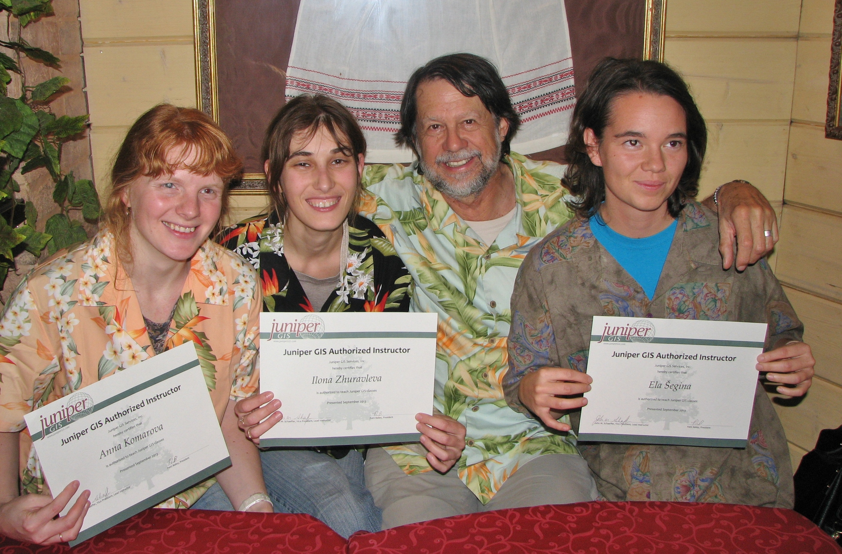
Ela Šegina (Right) proudly holding her new TTT Authorized Trainer Diploma with TTT Colleagues Anna Komarova (Left) and Ilona Zuraleva (Center left):
2013 Scgis Scholar Profile
Ms Ela Šegina
Email address(es): ela.segina at gmail.com
Title or role in the organization: researcher
Organization name: Geological Survey of Slovenia
Organization full street address (in your local format): Dimičeva 14, 1000 Ljubljana
Country: Slovenia
Work phone with country and area code: 00 386 1 2809 815
Work fax with country and area code: 00 386 1 2809 753
Organization Web site URL if any: http://www.geo-zs.si/
Organization subject keywords (please see instructions): geology, analysis, karst, landslides, conservation, data integration, environmental education, landscape analysis.
The Geological Survey of Slovenia provides information about the geological setting and natural resources of Slovenia and participates in the development of knowledge about past and present processes taking place in the Earth's crust. GeoZS collects, stores, and disseminates data about the geology of Slovenia and through international cooperation with its partners abroad extends its activities over the Slovenian borders.
The experts of the GeoZS are involved in the research, expertise and development within the frame of public services for the Slovenian government and the EU. GeoZS gives expert support and advice for geosciences related applied projects. We actively cooperate with the Slovenian universities in pre- and postgraduate educational programmes.
GeoZS is involved in research activities at home as well as abroad through the association with similar institutions and thus participates in the development of geosciences. It ensures comprehensive availability and use of knowledge for the society and industry, transfer of scientific achievements into practice, popularization of science, spreading of scientific culture and information for expert and general public.
I used a GIS as a conservation tool during my volunteering at a NGO CIPRA Slovenia, where we were developing a plan of revitalisation of the alpine lake. I was also working on a land use change in Koper, Slovenia. In my diploma thesis I performed spatial analysis of factors that cause rockfalls on coastal cliffs along the Slovenian coast and produced the geohazard susceptibility map of a large part of Slovenian coast. I participated at the conservation of a seagrass Posidonia Oceanica meadows in the Bay of Alghero, Sardinia, Italy. In my PhD thesis I performed numerous spatial analysis of karst surface features that contributed to the understanding of karst geomorphology and evolution of the karst surface on Krk Island in Croatia.
The most challenging in my GIS work is how to use a high-tech computer tools in interpreting and understanding something as basic as the nature.
2013 Scgis Conference Paper
Title: Use of GIS at cleaning of contaminated mountain lake in Slovenian Alps
Abstract: Dvojno jezero (Double lake) in the valley of Triglav lakes in Julian Alps, Slovenia, was contaminated by an anthropogenic introduction of fish (Salvelinus alpinus), which has demolished the food chain. Introduced fish has eaten all planktonic crustaceans, which until then successfully controlled the growth of the algae. Additional intake of nutrients is a consequence of inappropriate water discharges from nearby cottage, which has accelerated growth of algae. Revitalisation of lake water is necessary because most of the water is discharged into the Savica river, supplying Lake Bohinj and is also the source of drinking water in the area.
The aim of this paper is to present how GIS methodologies can upgrade knowledge about water flow through mountain lakes in karst area and how GIS can accompany the revitalization of the contaminated lake. Expected outcome is data, which will help to understand the water cycle of the lake. At the same time, maps as result of this research (3-D models, thematic maps) will act as visual supporters of the project and will help to make this environmental problem more transparent and understandable for general public.
2019 Scgis Conference Paper
Title: Using spatial data for modelling landslide susceptibility
Abstract: The landslide prediction system was developed to model the probability of rainfall-induced landslides occurrence in Slovenia. It is based on the three input spatial datasets: 1) landslide susceptibility map, 2) landslide triggering rainfall threshold values and 3) precipitation forecasting model. Statistical methods have been applied in analyzing spatial correlations between several environmental factors, precipitation forecast and existing landslide inventory. Potential landslide areas are forecasted twice daily on a national scale (1: 250,000) and on a local scale (1: 25,000) for selected municipalities and are available to the Administration of Civil Protection and open public via web-platforms. The system for landslide prediction constantly upgrades by implementation of different rainfall models, new parameters and incorporation of public risk. Additional calibration of input parameters and landslide inventory as well as improved spatial resolution of rainfall forecast data will further enhance the model's prediction and improve the landslides early-warning system.

You must be a registered user to add a comment. If you've already registered, sign in. Otherwise, register and sign in.