- Home
- :
- All Communities
- :
- User Groups
- :
- Conservation GIS
- :
- Documents
- :
- Induja Gandhiprasad, India
- Subscribe to RSS Feed
- Mark as New
- Mark as Read
- Bookmark
- Subscribe
- Printer Friendly Page
- Report Inappropriate Content
Induja Gandhiprasad, India
Induja Gandhiprasad, India
Ms. Induja Gandhiprasad, Auroville Planning & Development Group, Auroville, India
Organization: L’avenir d’Auroville (Auroville Planning & Development Group)
Town Hall, Auroville, Tamil Nadu 605101 INDIA WEB: http://www.auroville.org/
Your manager or faculty advisor: Prashant Hedao,
x2020 x2020Scholar x2020Talk xAsia xIndia xPlan xSustainable xWater xHydrology xBiodiversity xEducation xYouth xForest
"Architect at Auroville Town Development Council, 2018-present"
Auroville Volunteer Profile #1
“In an effort to make urban life less chaotic and more nurturing for our kids, Induja Gandhiprasad was a salient part of the ‘Bhubaneshwar Smart city proposal.” For 2 months, she performed a preliminary study and research for the highly ambitious proposal of creating a safe, family-friendly and supportive environment for raising children in the city of Bhubaneshwar.
She contentedly adds her experience working at Auroville: “This was my first work experience wherein I enjoyed such high levels of independence and support from my superiors.”
2020 SCHOLAR Profile:
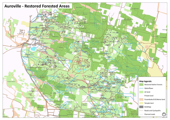
Auroville is a unique place where the biodiversity, the vegetation and the ecology were regenerated by the early Aurovilians on a barren plateau.This has played a significant role in highlighting the ecological importance of the place and the surrounding areas. The physical setting of Auroville is very interesting where all the water bodies in the surrounding areas are interconnected through water channels such that very little water flows into the ocean. This kind of situation clearly shows us that the conservation and sustainable planning work that we are currently doing and will continue to do so can not only be confined to the proposed city of Auroville but to a much larger region. So our work is largely focusing on the bio-regional planning, water and biodiversity conservation, creating green/biodiversity corridors etc., in and around Auroville.
The other unique aspect of Auroville’s work is experimenting with urban development where the ecology and biodiversity not just survives, but thrives in the middle of this urban expansion. This is something unique and ultimately can be replicated in other parts of the world.
Auroville also supports various experiments in green technologies including waste management, appropriate sanitation, renewable energy, water harvesting, biodiversity conservation, forest ecological restoration, sustainable green transportation etc.
You can find more information on Auroville’s vision and evolution here. (https://www.auroville.org/)
(Photo: A picture taken during our weekly cleanup. All Photos Courtesy of Induja Gandhiprasad )
Please describe the history of your personal work in conservation and GIS: I was naturally interested in the larger planning work (especially environmental planning) despite having an architecture background. This interest drew my attention towards Auroville and its vision in terms of living and planning. Starting from looking at the way Auroville has physically developed and restored a big ecosystem to being an experimental ground for a number of sustainable practices, Auroville has been an inspiration for me and its values very closely matched my interest. Since then I started involving myself and contributing towards the work in Auroville. I did my undergraduate studies internship from an architecture, landscaping and planning unit in Auroville and then after my graduation, about one and a half years ago I moved back to Auroville where I got opportunities to work with multiple Auroville agencies like the water group that work on water conservation of Auroville and its bioregion, waste-free auroville that work on effective waste management practices in & around Auroville through educational programmes and planners who work on urban planning including ecological restoration, planning and conserving biodiversity corridors as our urban areas expand and more natural landscapes are being converted for human use. I am also currently working on a planning exercise of defining watershed management methods including the proposals for green corridors in the development plan of residential areas in Auroville which is mainly done using GIS.

(PHOTO: Picture taken during one of our weekly cleanups along the roads around Auroville)
What is the most unique and the most challenging about the conservation/GIS work that you do?
Auroville, as an experimental international township created by an Act passed in the Indian Parliament, in its vision and the envisioned masterplan to be developed are unique. Starting in 1968 the way Auroville has developed from an eroded barren plateau into one of ecologically important places with a population working towards a larger vision of human unity to pioneering a number of sustainable practices in environmental management, Auroville is one of its kind. And most important of all is that the natural features, the interconnected biodiversity corridors, waterbodies, waste management, sociological aspects, etc shows us that the conservation work and sustainable development that we are aiming at can be meaningful and is possible only with the larger context of the surrounding areas. This extends the scope of all the works that we do beyond Auroville’s city limits which was also envisioned by the founder of Auroville, The Mother. Working with the surrounding hundreds of villages as stakeholders jointly working towards preserving the environment is a challenging task, as they work for their day to day survival
The other unique as well as a challenging aspect of Auroville is its own monetary system, where people who are part of Auroville as Aurovilians, volunteers, guests, etc don’t work towards a financial benefit but more towards a shared learning, experimentation spirit, and a constant search for beauty. People that are part of Auroville have minimal financial support in the form of a maintenance which is fairly the same for all, to sustain their day-to-day needs and be part of various Auroville activities.
Efficient data management in terms of geospatial data is one of the challenges our organization is facing. Simple and effective workflows that could help the day to day needs of the larger scale of sustainable development will help us in efficient data management and data integration.
I have an experience being one of the facilitators who trained a group of 25 young trainees on sustainability, water conservation, soil conservation and menstrual hygiene management, who were sent to a number of schools in remote villages in the state of Andhra pradesh, India to educate the children and teachers. The program was funded by Oil & Natural Gas Corporation (ONGC, India) and coordinated by Earth & US, Auroville.
I am also involved in conducting small workshops to rural village children in southern districts of Tamilnadu. I have been involved in waste management for the past one and a half years. With various waste management groups in Auroville, I had participated in organizing the event of climate strike, global brand audit and world cleanup day in Auroville which happened in September, 2019.

(PHOTO: Awareness workshop conducted for rural children about waste management )
Being the representative of one of the cleanup groups in Auroville, I had put forth a proposal for litter mapping in Auroville (inspired by the idea of #littermap) to show the visual impact of waste that is accumulated in and around Auroville. My idea is to use GIS for this exercise where geotagged pictures taken by our cleanup group can be spatially linked on the map and the impact of waste from the picture can be categorized based on the type of waste, number of pieces, etc. From which thematic maps showing the intensities of the waste in different areas of Auroville can be created and the data can be transferred into a mobile app where people can add geotagged photos into the app to update it.
The proposal and its funding is under discussion by the collective waste groups in Auroville.
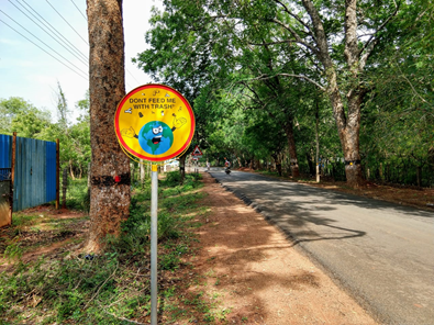
(PHOTO: Signboard designed by me on illustrator carrying message against littering with some trash in my hands )
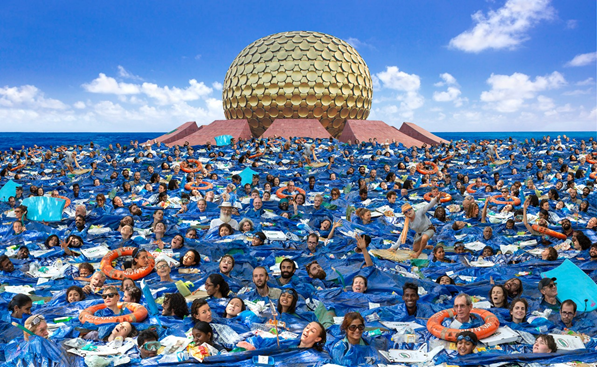
“In the ocean of waste”
(A picture (photoshopped with some real pictures) created Climate Strike Day 2019, to bring awareness about the consequences of unconscious consumption and improper waste management.)
2020 Paper Title: AUROVILLE - PLANNING FOR A SUSTAINABLE REGION
Abstract/summary of the paper you will present:
The site for Auroville was chosen to be approximately 20 square kilometres of barren plateau, some 10 km north of Pondicherry city and 5 km from the coast in southern India. A lot of efforts have been put in by earlier Aurovilians such as bunding, building of check dams for holding water and planting over 3 million trees to prevent erosion, and restoration of forest cover with the indigenous Tropical Dry Evergreen Forest (TDEF) species.
Mother had emphasized a lot about bridging Auroville with bioregion, which is very much a reality as we are connected to the bioregion in terms of water table, village communities as stakeholders in the Auroville experiment, social infrastructure, etc. And mainly because Auroville lies in the watersheds of Kaluveli lake to the north, an inland waterbody connected to the ocean and designated as a Bird Sanctuary by the State Government and Ousteri lake to the southwest, which is a manmade lake and also a Bird sanctuary).
This paper will be focusing on how we are foreseeing our work towards conserving and restoring the ecological biodiversity in Auroville & it’s extended bioregion and also managing the Urban development in Auroville while conserving the environment using geospatial technologies and analysis.
-
 Anonymous User