- Home
- :
- All Communities
- :
- User Groups
- :
- Conservation GIS
- :
- Documents
- :
- Dr. Ana Garcia Cegarra, Chile
- Subscribe to RSS Feed
- Mark as New
- Mark as Read
- Bookmark
- Subscribe
- Printer Friendly Page
- Report Inappropriate Content
Dr. Ana Garcia Cegarra, Chile
Dr. Ana Garcia Cegarra, Chile
Dr. Ana Garcia Cegarra, Marine Fauna Research and Whale-watching Center (CIFAMAC), Chile
Marine Fauna Research and Whale-watching Center (CIFAMAC NGO)
Jesus Tejada 621, PC: 1310000, Mejillones, Antofagasta, Chile.
Phone: +56981282252 Main email: Web site
ResearchGate Profile FACEBOOK profile
Rufford Grantee Report 2017: “From Whales to Humans: An Integrated Evaluation of the Conservation Role of Whale Watching Industry in the Northern Coast of Peru”
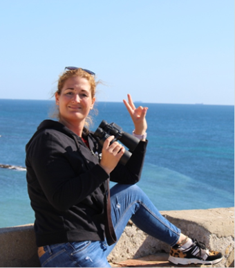
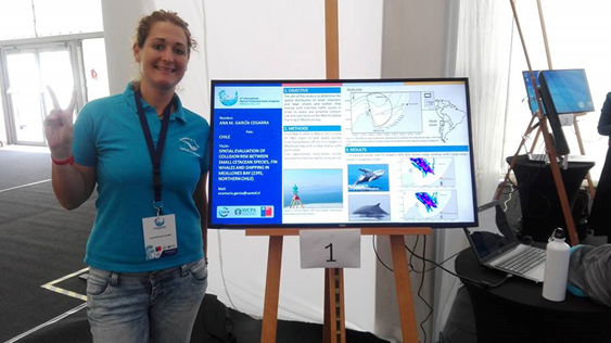
(RIGHT: Figure 1: Ana in the cliff observation point. All Photos & Maps herein courtesy of Dr. Ana Garcia Cegarra)
Interviewed by the “Oceanicas Project” (The project "Oceanic: women and oceanography" aims to disseminate the work of scientists dedicated to the study of the oceans, both current and past, to publicize their life and work, thus trying to generate scientific vocations in girls and boys , promote their creativity, their decision-making capacity and equal treatment against gender inequalities from an early age.)
Oceanicas Article 2018 "Ana María García Cegarra and the conservation of Cetaceans"
“I am currently working on my doctoral thesis at the University of Antofagasta and I am trying to determine if human activities such as maritime traffic, whale watching tourism and pollution have negative effects on the well-being of different cetacean populations in Chile and Peru.”
La Verdad Article: (Leading newspaper of Murcia region, Spain) “The Murcian woman who defends whales on the coasts of Chile”
Ana Alemany tells in the book 'Women of the Seas' the story of the Sanjaviereña Ana María García Cegarra, founder of the Center for Research on Marine Fauna and Whale Watching of Antofagasta
 Cifamac Center for Research on Marine Fauna and Whale Watching
Our history " CIFAMAC CENTER FOR RESEARCH ON MARINE FAUNA AND WHALE WATCHING · SATURDAY, MARCH 2, 2019 ·
We were established as a non-profit organization in 2016. We are a multidisciplinary team of researchers, fishermen and the local community of Mejillones interested in the conservation of marine fauna. Our objective is to value the Natural Heritage of the Mejillones Peninsula through environmental education, research and promotion of marine fauna observation tourism.

(Photo: A family of orcas photographed in Mejillones Peninsula.)
“Cetaceans inhabit marine coastal systems where numerous human activities take place. They are subjected to human threats such as collision with vessels, pollution from industry, habitat depletion, by-catch or underwater noise. To understand how different human activities affect the welfare and survival of endangered cetacean species such as large baleen whales is crucial in order to manage their conservation status. The coast of Atacama Desert in Northern Chile is subjected to an intense mining industry which lead the growth of marine traffic and industries in the coast. The abundance, distribution and habitat use of cetacean species is poorly known in northern Chile, specially in the high polluted area of Mejillones Bay. In 2014 I started my PhD to characterize distribution of large baleen whales such as fin whales and humpback whales and the potential collision risk with large cargo vessels. During the performance of my field work I met local fishermen interested in the conservation of cetaceans and we decided to found in 2016 the Marine Fauna Research and Whale-Watching Center NGO (CIFAMAC). Since then we have carried out conservation research efforts in cetacean and seabird species of Mejillones Bay. To continue our work in conservation and perform workshops with local authorities regarding the needed to mitigate human threats such as pollution and marine traffic on the survival and conservation status of cetacean species I aim to improve my skills in the use of ArcGIS tools. To work in conservation is not just to understand biology or ecology of species but to work collaboration with authorities and stakeholders to mitigate human impacts on wildlife species. The use of ArcGIS as a tool of conservation of species allow us to inform local authorities, fishermen and scientific community about the conflictive areas where human activities and cetaceans coexist and implement conservation plans as the best way to live in harmony.

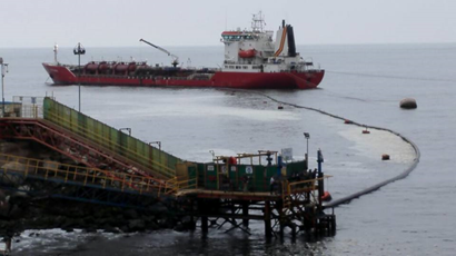
(Figure 10: Ammonium spill in Mejillones Bay near the beach where children swims and sulfuric acid spill in a major seaport.)
Since we created CIFAMAC NGO we have been funded by national and international organizations such as the Regional Environmental Council of Chile, Porpoise Conservation Society or Pacific Seabird Group. However we have not received any funds from private companies or industries due to the conflicts of spills in our study area (MAP 2). Working in conservation is challenge due to work with wildlife species in conflictive industrialized areas. In our cases the common spills of sulfuric acid or ammonia to the marine environments put us in a danger zone. As NGO we cannot receive money from the industries that contaminate our marine environment and study sites. This is against our principles and moral, how can we defend cetaceans from pollution if we received money from the polluted industries that pour huge quantities of trace elements and persistent organic pollutants to the marine realm? Then the research that we perform is with Government agencies or international organizations and small amounts of money that just cover laboratory and field expenses. Greatly needed is any possible support to acquire the skills needed to improve our research in ArcGIS and be able to show better results to local authorities in managing the conservation of cetacean species in Antofagasta Region.
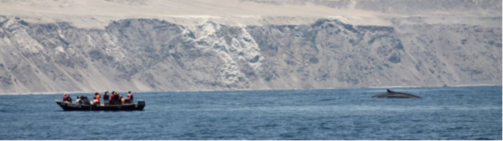
(Figure 3.1: Observing fin whales from boat based surveys in the Atacama Desert Coast.)
I am co-founder and main researcher of a local NGO called CIFAMAC (Marine Fauna Research and Whale-watching Center) located in Mejillones, a small city located in Atacama Desert Coast (Northern Chile). The aim is to promote conservation of cetacean species through research and environmental education. CIFAMAC was founded in 2016 by local fishermen and myself with the aim to promote responsible whale-watching and understand abundance, distribution, residency patterns, habitat use and human threats of cetacean species.
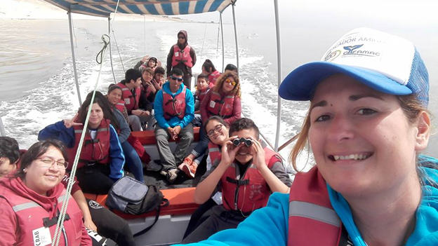
(Figure 8: Boat survey with children to quantify marine debris, abundance of sealions and Humboldt penguins in Mejillones Bay.)
I also have experience teaching environmental education in local schools to children from 4 to 12 years old. In classes of 30 students. I have performed environmental education talks to children at schools regarding marine litter and threats to marine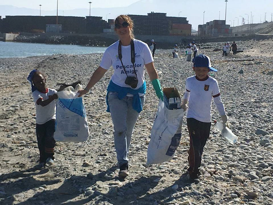 fauna (Figure 5). I have leading marine research with local children and beach cleanings (Figures 8 and 9). I have performed talks in local community audience and also to local authorities regarding issues such as pollution threats to cetaceans. I have performed lessons to fishermen regarding whale-watching guidelines and marine fauna species identification. I have lead conservation research and I am co-director of the thesis of an undergraduate student of Marine Biology Degree.
(Figure 9 right: Beach cleaning with children from local schools. )
We have performed environmental education projects such as Friend Fishermen project funded by the Antofagasta Regional Council of Environment (2018) and we have celebrated the First Mejillones Whale Festival funded by the Chilean National Fund for Regional Development (FNDR 2% Culture, 2019). We have been funded by international organizations such as the Porpoise Conservation Society in Canada (2018) to investigate the distribution, abundance and habitat use of Burmeister’s porpoise in Mejillones Bay. In 2019 we were granted by The National Geographic Open Explorer Science and Education Initiative with a Remote Operated Vehicle (ROV) to investigate body condition of large baleen whales in Mejillones Peninsula. We have received funds also by the Pacific Seabird Group to analyze marine debris in nests of red-legged cormorant (Phalacrocorax gaimardi) and Inca tern (Larosterna inca). We are partners of the World Cetacean Alliance to promote responsible whale-watching in Chile and be able to train and certificate local fishermen who wants to perform whale-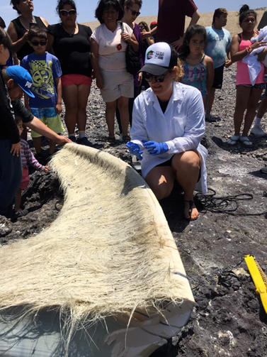 watching. Since CIFAMAC is working in Mejillones, local and regional people started to know the species of whales, dolphins and porpoises present in their coast. We have performed interviews in regional and national newspapers and television regarding environmental issues such as the presence of killer whales in Antofagasta Region, stranding of fin whales or seabirds building nests with plastic debris. We assist to cetaceans strandings along Antofagasta Region coast and we performed necropsies in collaboration with the Rescue and Rehabilitation Center of Antofagasta University (Figure 4).
(Figure 4 Left: Assisting the stranding of a fin whale (Balaenoptera physalus) in Antofagasta and taking baleen tissue samples. )
What is your role in the organization? I am main researcher in CIFAMAC and co-founder since 2016. I am involved in overall projects in the organization as I am the grant seeker. Currently we have two projects:
- Abundance, distribution and habitat use of Burmeister’s porpoise in Mejillones bay. Funded by the Porpoise Conservation Society (Canada)
- Characterization of plastic debris in nests of red-legged cormorant and Inca tern in Northern Chile. Funded by the Pacific Seabird Group (UK).
I am the main researcher in both projects. I apply for funds and I perform boat based and beach based surveys, I gathered data, analyze data and write reports and scientific manuscripts.
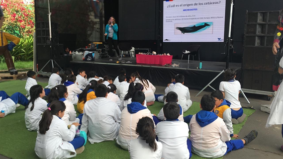
(Figure 5 right: Talk to children about cetaceans species identification and marine debris.)
The highlight of my work is enabling local communities to understand and become aware of the presence of cetacean species on their coasts (Figure 5). I also enjoyed helping create a network with local fishermen as citizen scientist who are able to distinguish among cetacean species and capture data such as geographic position with GPS, abundance and behavior. In addition we have created a workshop with governmental authorities such as the Regional Environment Ministry, Chilean NAVY and Industry to create the first marine traffic separation scheme in the Mejillones region to avoid the presence of whales in the Bay.
(Figure 6: Assistance to the International Marine Protected Areas Conference, IMPAC 4. La Serena, Chile, 2017.)
In 2020 we would like to apply for funds or the creation of an Environmental Education Center in Mejillones. I had the opportunity to present scientific results in different national and international conferences (Figure 6).
What is your history of work in conservation and GIS? Since I started my PhD in 2014 I performed land-based surveys in Mejillones Peninsula, searching for whales with the use of a theodolite and characterizing marine traffic paths and speed. Then I met two local fishermen Juan Menares and Raul Riquelme who wanted to start to perform whale-watching but they did not know which species of cetacean inhabited the bay, when or where. Then we decided jointly to create CIFAMAC NGO. Today we are more than 10 researchers and fishermen in CIFAMAC and we have successfully performed environmental education and research projects.
To study marine traffic and collision risk with cetaceans I needed to use ArcGIS then I decided to take a workshop in the SOLAMAC Conference in 2016. Then I learned how to use ArcGIS and how to analyze my data and create marine traffic density maps and cetacean distribution maps. The results of my study of marine traffic were published in Marine Policy journal, and currently local and regional authorities participate in the first regional workshop to create the Marine Traffic Separation Scheme in Mejillones. This Traffic Separation Scheme is also created with ArcGIS (Figure 7). To work in conservation is not just to investigate biology or ecology of wildlife, but also to work with stakeholders such as fishermen, local communities and authorities to create the tools needed to mitigate human threats in the welfare and survival of wildlife species.
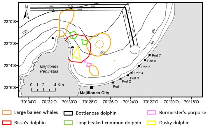
(Figure 7: MAP right: 95% Kernel Density distribution map of cetacean species in Mejillones Bay and proposed Traffic Separation Scheme. )
What is your connection to the local SCGIS chapter:
In Chile there is no local SCGIS Chapter. However I have contact with Geomatic and Geomensure Faculty which permits some access to ArcGIS licenses every year. In Latin America I have connected with Scgis TTT Trainer Federico Riet and I participated in an ArcGIS course with him.
What is most unique and the most challenging about the conservation/GIS work that you do:
The most challenging part of working with conservation is to speak with local authorities about the threats and impacts of human activities specially pollution in the marine environment, and create the tools to mitigate the threats. For example Mejillones Bay is a conflictive area as there is a big industrial area installed in the east coast of the Bay. The industry is composed of thermoelectric energy factories, manufacturing of explosives and liquid natural gas transport from large cargo vessels. Those industries generate damage to the marine environment due to the spill of substances such as ammonium, sulfuric acid and carbon pet coke (Figure 10). I investigate habitat preference of cetaceans and primary results indicate that they avoid the use of the industrial area. For us, as a local NGO it is difficult to speak with industry managers and create collaboration agreements such as they are more worried about the production of electricity than the damage to the environment. We understand that these are problems that should be written in the Chilean Law, but they are not. It is easy to investigate marine wildlife but it is difficult to develop legislation to protect them. The most unique is that from my research of marine traffic and collision risk with large baleen whales Chilean NAVY authorities and Regional Environmental Council have good disposition to create the first Traffic Separation Scheme in Mejillones Bay to mitigate collision risk. The maps that I created from my research of conflictive overlap areas among large cargo vessels and whales have been so important as a tool to show results of my research and the needed to mitigate this human threat to cetacean welfare and survival (Figure 11)

(Figure 3 right: Observation point and total station setup in Punta Angamos Cliff, Mejillones Bay.)
How did you learn GIS & what do you use it for?
In 2016 I received an ArcGIS course under the direction of Federico Riet in the Conference of Specialists in Aquatic Mammals in Latin America (SOLAMAC). During this short course I learnt how to perform ArcGIS maps and use Kernel Density Spatial Analysis tool in ArcGIS. Back in my University I assisted to lessons in the Geometry and Geomatics Engineering Faculty.
In 2017 I was able to apply the things learnt in the course in my own research. I investigated the potential collision risk areas between large cargo vessels and fin and humpback whales in Northern Chile. I performed spatial analysis tools in ArcGIS and created risk maps by overlap analysis of cells with high density of large cargo vessels paths and 50% and 95% kernel density areas of fin and humpback whales distribution (see map below). I gathered my data from a land based observation point (Figure 3) by using a theodolite which I registered vertical and horizontal angles of large cargo vessels paths and the presence of any cetacean species within Mejillones Bay in northern Chile (23º2.804’S; 70º19.982’W). In the laptop I transformed vertical and horizontal angles obtained with the theodolite to geographic coordinate position in excel datasheet. I used coast, land and bathymetry layers of Mejillones Peninsula and I performed the study area map. I load excel with geographic coordinate positions of vessels paths and cetaceans distribution in the study area map. I used bathymetry raster layer to analyze the distribution of cetaceans according to depth and shore distance. I extracted distribution depth of cetaceans to a new excel and I performed General Linear Model Analysis in Rstudio software to determine if the distribution of each cetacean species differs according to depth. I found positive results, whales species are distributed in higher depths and distance from shore than dolphin species and among dolphins, the bottlenose dolphin is the most coastal distributed species. Risk maps and the results of my research are published in Marine Policy journal “Risk of collision among small delphinids, large baleen whales and marine traffic in Mejillones Bay (23ºS), northern Chile” 2019.
Current GIS Interests:
I am interested in learning how to apply ArcGIS statistics analysis to differences in distribution of cetaceans based in shore coastline distance and depth. I would like to learn how to use ArcGIS Platform and how to find maps of different areas. For example sometimes is difficult to find maps from South America with layers of land and coast. I would like to learn how to digitalize a map and be able to georeferencing map images in ArcGIS. I would like to learn to create better maps, with more information such as labeling features and work with annotation. Also improve cell analysis tools, create raster layers and calculate areas in polygons created such as Marine Protected Areas. I have my own data of Burmeister’s porpoise distribution and abundance in Mejillones Bay. I performed boat based line transect surveys and I applied distance sampling method. I have my data sheet but I have not yet analyze data or performed the distribution map. I would like to know at which depth Burmeister’s porpoises are distributed in the Bay, their habitat preferences and relation with shore distance. I would like to assess their abundance and residency patterns. Also understand if their distribution overlaps with floating macro-plastics in the bay. I performed 3 years boat surveys and gathering geographic position, type, size and color of macro-plastics floating in Mejillones Bay. I would like to assess whether their distribution overlap with the distribution of Burmesiter’s porpoise and assess the percentage of habitat overlap. I would like to create risk map of probability encounter of Burmeister’s porpoise with floating macro-plastics.
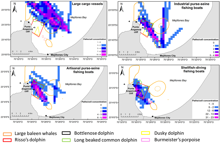
(MAP 2: Collision risk maps of small and large cetaceans in Mejillones Bay and large cargo and fishing vessels. )
Title of the paper you will present to the SCGIS Conference:
Collision risk areas between fin and humpback whales with large cargo vessels in Mejillones Bay (23ºS), northern Chile.
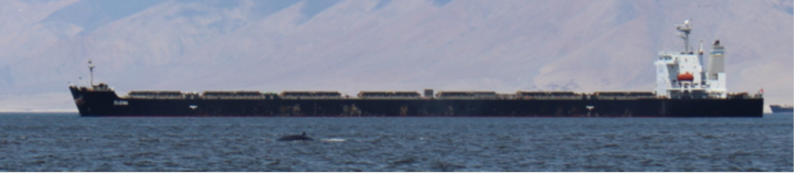
(Figure 11: Fin whale near a large cargo vessel in Mejillones Bay.)
Abstract: Enclosed areas such as embayments with high levels of marine traffic may put at co-occurring cetaceans at risk due to collisions with vessels. The distribution of seven cetacean species and their spatial overlap with navigation routes of large cargo ships, fishing vessels and recreational vessels were evaluated of the major port in Mejil- lones Bay, northern Chile. Shipping distribution, navigation speeds and cetacean positions were obtained from land-based theodolite surveys. Sighting positions were also recorded from boat-based surveys. Overlap analysis based on 50% Kernel density estimations suggested that the spatial distribution of fin and humpback whales overlapped with a high concentration of large cargo vessel navigation paths. These results point to the need for the implementation effective regulation of vessel speed to mitigate the risk of collision in Mejillones Bay.
x2020 x2020Scholar x2020Talk xLatinAmerica xChile xWomen xLatinx xEducation xMarine xMammal xWhale xDolphin xYouth xMonitoring xSurvey xArcGIS xCommunity xFishery xEcotourism xPlan xPolicy xPollution
-
 Anonymous User