- Home
- :
- All Communities
- :
- User Groups
- :
- Conservation GIS
- :
- Documents
- :
- Andrianoely Herilala, Madagascar
- Subscribe to RSS Feed
- Mark as New
- Mark as Read
- Bookmark
- Subscribe
- Printer Friendly Page
- Report Inappropriate Content
Andrianoely Herilala, Madagascar
Andrianoely Herilala, Madagascar
Navigation: 2017 Scholar Project 2017Conference ReferenceProject CommunitiesPage ConservationGIS Scgis.org ![]()
![]()
Andrianoely "Dina" Herilala , Centre ValBio , Madagascar
*-Organization name: Centre ValBio
*-Organization Street address: BP 33-Ranomafana, Ifanadiana 312, Fianarantsoa, Madagascar
*- Organization mailing address: Institute for the Conservation of Tropical Environments, Lot VU 283 D Villa ROTCIV Manakambahiny, Antananarivo, Madagascar
*-Country: Madagascar
*- Work phone with country and area code: : +261 34 13 581 71
*-Main email: centrevalbio@gmail.com
*-Scholar email: andrianoelydina@gmail.com
*- Organization Web sites: : www.centrevalbio.org, www.icte.bio.sunysb.edu, and www.teamnetwork.org
*-ORGANIZATION’S WORK: The mission of Centre ValBio is research, training, and conservation outreach. Research comprises individual research project by foreigners and national PhD or Master’s students within different domains, such as, behavioral ecology, inventory of fauna or flora, phenology of plants, monitoring of different species of lemurs, entomological and anthropological research. The center hosts also different projects on environment such as “Tropical Ecology Assessment and Monitoring (TEAM)” project that focuses on monitoring of vegetation, terrestrial vertebrates, and climate, which has been conducted since 2010. Several programs of study abroad are also held at Centre ValBio for international and national undergraduate students from different Universities, such as, of Antananarivo and Fianarantsoa, Helsinki, Stony Brook, New York, University of California of Pennsylvania. Centre ValBio has also programs in reforestation, health and hygiene, and biodiversity conservation awareness within several villages and schools surrounding Ranomafana National Park.
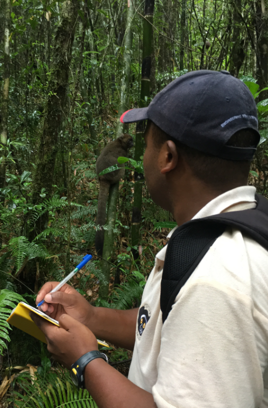
*-ROLE IN THE ORGANIZATION: As my role (biodiversity assistant), sometimes I lead expeditions in the field with my colleagues and most of the time I work in the field collecting data from the lemurs activities, territories, foods.
Use the coordinate data on ArcGIS, and Map source for the projection.
Entering the data from the field as DATABASE for the Center.
Sensitize the local people living very close to the forest, let them know about the causes of the deforestation, and hunting that they did made before, and to some extent even now. Make theme understand the climate change, I report and discuss with the local partners, and give advice to the organization NGO how to keep and have a good management for  the conservation.
history of your personal work in conservation and GIS: I am a local person from the country side of Ranomafana National Park (Madagascar) and my tribe is the TANALA which means “ the peoples in the forest”. Our ancestors are the first responsible for the destruction of the forest for the southeast side of Madagascar. I don`t know what conservation was, but by accident I met one researcher (Alex Dehgan) who is a Primatologist working in different fragment forests surrounding the National Parks, he was stuck in the mud with his motocycle near the village where I lived and he came to ask a help, I was the only person who can understand French, but he speaks English, and a little bit of French.That was December 1999 and it was very difficult for us to understand each other , and during the discussion sometimes we use hand. Mr Alex Dehgan has left his materials ( in two black boxes), and motocycle with me, he said “ could you take care my stuff and said he will be back to pick those next time”. I said yes. In April 2000 he came back and brought a vehicle (4X4), I remember his first word “Dina I trust you” sorry for the delay, because I`m just back from United States of America, and sorry to give you a big responsibility to take care my stuff, He explained what he is doing in Madagascar. At the end, he asked me to join his team if I am interested. I said may be yes, but let me figure out because I`m still studying at school. He said, then, if you are ready during the holydays you are welcome. August 2000, I came to visit him, so my history started from here. When I arrived to his field camp site, my first question was how I can survive here such as to sleep in tents, he asked me do you know lemurs, how many species you have seen? I said yes I know one. He said to me again Dina if you want to stay here, I can hire you, and you can learn the work with my guide, he said »I think you are going to like and learning those things very quick ».
September 2000, I started working and get salaries, but the problem was that my parents are waiting for me to go back to school, but I like the work because I learn about the lemurs behavior, carnivore animals, birds, plants, and learn English too, so I was very interested and excited about the research in the field with the life and conservation of the biodiversity in Madagascar. In 2001, Alex Dehgan introduced me to his professor Dr. Patricia Wright, Anthropology Professor at the University of Stony brook who was also the creator of the National Park of Ranomafana, and the foundation director of MICET (Madagascar Institute Conservation Tropical and Environment). Patricia Wright said when Alex Dehgan is  down for his work in Madagascar she will be hiring me to join her team in Ranomafana. 2003 November, I came to Ranomafana and spoke to Dr. Pat Wright and few weeks later I got my job there.
I was very lucky to find my job because I learnd a lot of things to connect in my work such as GIS, customs, histories about Madagascar in conservation, and I had a chance to meet many peoples who work on conservation and trainers on Biodiversity. I started to use MapSource and Google earth for the beginner in 2005, so from 2006 there was a lot of trainings and capacity building on GIS that I was assisting.
*-ROLE IN THE LOCAL SCGIS CHAPTER: Please describe your connection to the local SCGIS chapter: My connection with SCGIS was through our National Director who is member of this Chapter and one time our Research Center hosted the celebration of GIS day. That was the time when I had a chance to meet with the other members of the Chapter and could see what was the chapter all about.
*-Title of the paper you will present: Spatial distribution of Bamboo (Cathariostachys madagascariensis) and endangered Greater Bamboo lemur (Prolemur simus) territories in the Ranomafana National Park of Ranomafana.
*-Abstract/summary of the paper you will present: Madagascar is one of the hotspot areas in the world in terms of biodiversity conservation with a high endemism in fauna and flora. At the same time, this biodiversity is threaten by pressure happening in the habitat of the wild animals. In this case, I am looking at the problem of the habitat of one endangered species of lemurs that depend on Bamboo as a food. Therefore, I will use field expedition and GIS technology to collect information on the spatial distribution of the Bamboos and the territory of the Great Bamboo lemur. To do it, I use GPS to locate and track the areas where there is Bamboo forest around the National Park. I will set up transects within these bamboo forest to know the densities of the Greater Bamboo lemur in their habitats.
All the data from the expeditions will be put and transferred into computer with GIS software for making maps and for further analyses.
At the end, I will give recommendations to the Park Management to preserve these important and also one of the flagship of Ranomafana forest area.
xIndigenous xPark xPrimate xEndangered X2017Scholar x2017Talk xTalk xScholar xMadagascar xAfrica xPOC
-
 Anonymous User