- Home
- :
- All Communities
- :
- User Groups
- :
- Conservation GIS
- :
- Documents
- :
- Claudel Tshibangu Lukusa, DR Congo
- Subscribe to RSS Feed
- Mark as New
- Mark as Read
- Bookmark
- Subscribe
- Printer Friendly Page
- Report Inappropriate Content
Claudel Tshibangu Lukusa, DR Congo
Claudel Tshibangu Lukusa, DR Congo


Claudel Tshibangu Lukusa
Forgotten Parks Foundation (FPF) DR Congo current email
2019 Profile: Claudel is a participant in the first-ever SCGIS TTT Summit Meeting.
2019 International Conference Presentation
2019 Map Gallery Interviewer TEAM CATILAN
Photo Below: Claudel teaching one of his recent Conservation GIS Classes in DR Congo in 2017

2016 TTT Profile: Claudel is accepted as TTT Candidate for the SCGIS 2016 Scholar Training Program in Cameroon. The  class was organized by SCGIS Scholar and Cameroon Chapter Leader Buh Gaston, with funding from Esri and the World Wildlife Fund Education for Nature program. ArcGIS for Environmental Analysis and Advanced Topics for ArcGIS, were taught in July, 2016 at the Limbe Botanical Gardens in Limbe, Cameroon (Photo Below, Claudel (R) receives his formal TTT Certificate with Buh Gaston(L) )
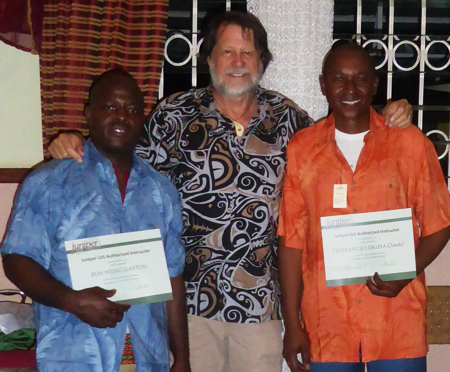
(Online Gallery of more photos by John Schaeffer from the SCGIS 2106 Cameroon Training Course)
2013 Scholar Profile: Mr Claudel Tshibangu Lukusa Communications and GIS assistant , FRANKFURT ZOOLOGICAL SOCIETY
DEMOCRATIC REPUBLIC OF CONGO
email: claudeltshibangu at fzs.org frankfurtzoologicalsociety@gmail.com
URLs: www.fzs.org, www.callfromthewild.orghttp://www.facebook.com/UpembaNationalPark?ref=hl
OVERVIEW: Claudel’s home country of Democratic Republic of Congo is home to iconic wildlife such as zebras, elephants and gorillas. It is also the setting for intense violence and political instability. Despite this reality and despite the dangers, people such as Claudel have put conservation first – even ahead of their own lives. Claudel is using GIS to help rehabilitate struggling national parks that are home to some of the last zebra herds, the last elephants, and the last gorillas on the planet. He wants to help create a future for these parks by implementing proper management plans and providing local wildlife authority personnel with accurate data, maps and analysis. He is currently the only GIS analyst for the 10,000 square mile parks that are in dire need of updated management. Claudel began his career in international media organizations as a video journalist and translator, and worked on some prominent projects including the BBC’s Africa series and Human Rights Watch. Claudel sees the importance of outreach on a global scale, and the need to communicate to a broad audience the importance of conservation and how GIS plays a vital role in effective conservation worldwide. (Photo Above/Left, Claudel, standing, teaches GPS techniques to conservation workers)
Claudel's own words:: Please describe the work that your current organization does: Frankfurt Zoological Society is a German  based conservation Organisation. The project is focused on the rehabilitation project of Upemba and Kundelungu National Parks, financed by the European Union. We are working to re-organize park management, the surveillance system and introduce new monitoring methods by using new technologies such as GIS and GPS tools. The GIS project is linked to the “General Management Plan” that will lay the ground-work of rehabilitation of the two Congolese national Parks, Upemba and Kundelungu that are situated in Katanga Province. This plan has eight management programs focused on the protection of the species and habitats in these areas. In order to know what to protect and where to focus support, the management plan should include accurate maps (not previously available) and a system of data collection and monitoring is being developed. The project has employed technical assistance in building GIS / Remote Sensing / GPS-based tools from Dr. Steve Schill, a senior scientist at The Nature Conservancy and Dr. Robert Ford, an expert with GIS research and field teaching experience. We bought and collected data from different sources (Google Earth, NASA, Tervuren Museum in Belgium, GPS-based data collection in the park) in order to create a first draft GIS database as well as critical documents that will help us to define the future of the parks and increase management capacity.
Please describe your personal role in the organization: My job is twofold – I am the Communications officer and I serve as GIS Analyst. Even though I have a background in journalism and communications, I have been learning GIS and now support all the GIS work in the organization within the region. I see GIS as a critical tool that will help us improve management capacity. Consequently I am seeking to further my education in GIS so that I can help train our other team members how to use this valuable tool. I am currently using GIS to create new baseline layers for our database such as shapefiles and KMZ/KML files in Google Earth. I’m also leading teams in the field to collect data using GPS and importing these files into our GIS database for the two Parks. I also create basic maps as needed for park management. I assist in the GPS training for the wildlife authority to support the new management plan that will lay the groundwork of rehabilitation of the two Parks - Upemba and Kundelungu in Katanga (DR Congo). I also review maps made by consultants and verify the proper use of local names. I manage the GIS database that we’ve created with the help from consultants for both parks. This will be my second year working to use GIS for conservation and I see great possibilities in using this technology to help rehabilitate the parks that are in great need of increased management – this is why I’m very keen to learn more from the SCGIS scholarship program – so I can give my best to use GIS for promoting conservation in my country.
Please describe the history of your personal work in conservation and GIS: I came to FZS from International media organisations where I worked withInsight News TV, and Von Planta Productions. Here I worked as a video journalist and fixer translator. I also helped organize the DRC part of Jonathan Dimbleby’ s BBC African series.
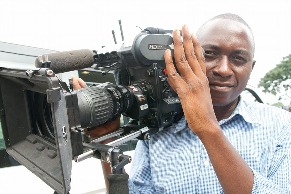
In 2009 I filmed reports for Human Right Watch about sexual violence against women in Eastern Congo. I accompanied HRW executive director Ken Roth and Ida Sawyer to film the HRW press conference and got some footage of advocacy activities that were used for an outreach film on Congo.

I’ve been involved in conservation and GIS since 2009, when I visited for the first time a National Park in Eastern Congo. I remember that I was invited by the organization I’m currently working for to Kahuzi Biega National during the attack of Laurent Nkunda (a rebel leader). The park was occupied by different rebel groups who where digging minerals such as gold and cassiterite. The head of the Park was concerned by this situation as these people were destroying the habitat for mountain Gorillas through their mining activities within protected areas.
They asked the current FZS Africa Program Director Rob Muir - to get information using GPS from the FZS airplane. Since that time I have been looking for GIS/GPS training, but didn’t get a chance to learn more until last year when I joined FZS’s Upemba Project. (see 2013 poster below, click for full resolution version)

Please describe what is the most unique and the most challenging about the conservation/GIS work that you do: The most challenging thing about conservation/GIS where I work is the lack of data and the versions of GIS software. It’s difficult to work with old versions especially when I get shape files made from the latest versions. I’m working in the most dangerous place where Congolese army is fighting regularly for years now against different rebel groups.
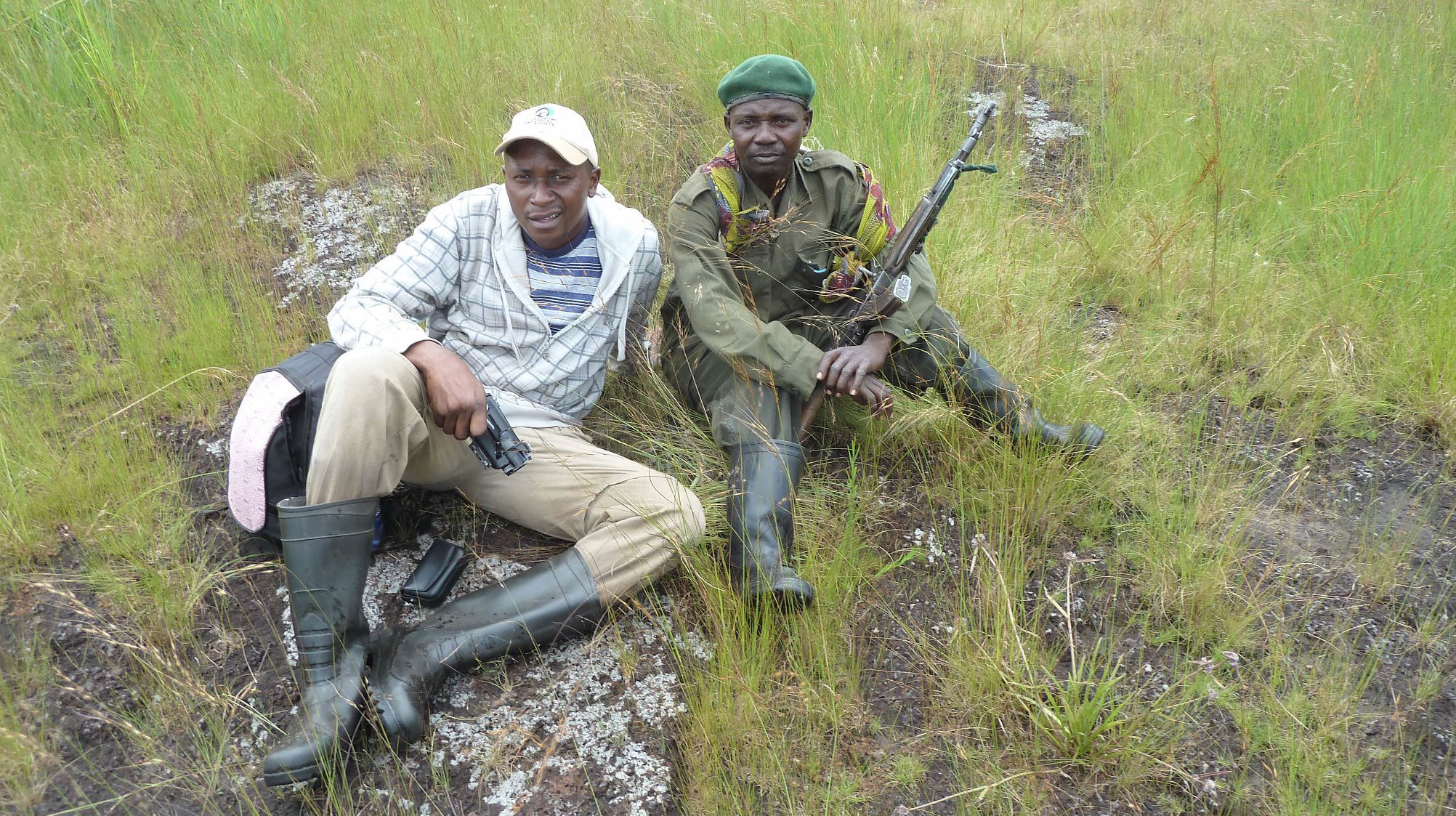
This causes many problems for our project and for collecting data in the field. Recently, in a tragic event, local “Mai Mai” rebels murdered Mr Atamato Madrandele, Upemba Chief Warden on December 16 2012 on his way to the park. This danger means that access to different areas of the parks to confirm the  images we see from Google Earth is difficult or impossible. There is a lack of technical knowledge and skills from park managers, which means that I have to accompany people on the field to make sure they collect the correct data. Overall, working in Congo is one of the most challenging places in the world to do conservation, but this also means that we really need training and new tools like remote sensing to help our work.
Please describe a 1-year plan for how you hope to apply the skills you will learn under the SCGIS scholarship, and what you expect to be able to achieve in your conservation GIS work over the next year. I’m planning to apply my skills to the project that will be done in Upemba Park to protect the last herds of zebras left in the country as well as try to protect and restore other species left in the Park. There is a survey that will happen next year in order to research and try to save the last elephants of Katanga, which are now living outside the Park and are very vulnerable to ivory poachers. They fled from fighting and now we hope they will come back to their original habitat. I will work closely with the Biologists and experts to make sure they have all the maps they need to make management decisions and determine the best habitat and corridor routes for these elephants. I plan to create a map of elephant sightings and other topics that are important for park managers. My new skills acquired through the scholarship program will help me to improve GIS database management and analysis that will contribute directly to the future success of the Park. After this year, I believe there will be a lot of opportunities for GIS and conservation in DRC, since the capacity is very low with the wildlife authority. They will require trained GIS experts to assist with management and monitoring in every park in DRC.
xTTT2019 x2019TTT x2019TalkMap x2019ConfInterviewer x2016Trainer xScholar2013 x2013Talk xChapter xDRCongo xAfrica xJournalism xPark xClimate Change xStorytelling xPOC
-
 Anonymous User