- Home
- :
- All Communities
- :
- Industries
- :
- Public Safety
- :
- Public Safety Blog
- :
- FDNY USES GIS TO INTEGRATE DATA FOR SPECIAL OPERAT...
FDNY USES GIS TO INTEGRATE DATA FOR SPECIAL OPERATIONS
- Subscribe to RSS Feed
- Mark as New
- Mark as Read
- Bookmark
- Subscribe
- Printer Friendly Page
- Report Inappropriate Content
by Mike Cox, Director of Fire & EMS Solutions
Responders make critical decisions based on limited information every day. Agencies should strive to generate verified data for emergency response to provide that responder with the right data at the right time. Fire and EMS departments can integrate disparate data from multiple sources that can be used to perform incident assessments, monitor response actions, and to provide a higher level of responder safety based on verifiable intelligence.
Fire and EMS agencies need tools to adapt to fluid risks and to support a variety of mission requirements. Today, we must be able to identify changing incident conditions, collaborate and unify operations in an all hazard environment, rapidly respond to events, communicate with the public, and analyze the success of those efforts. Through the power of geospatial technology, organizations can now adopt a smarter, more integrative approach to emergency response.
The ever-present threat of terrorist activity and complex day to day operations regularly challenge the Fire Department of New York (FDNY). The FDNY continually seeks technology and methods to increase the impact of their response to significant incidents.
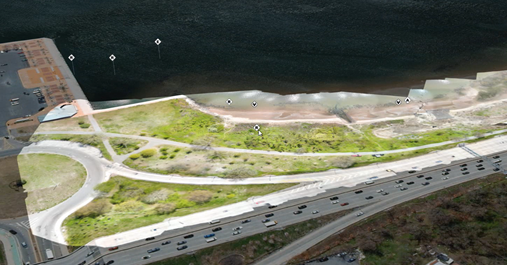
Esri Public Safety personnel and our partner Leica Geosystems were deployed to a full-scale exercise with the Fire Department of New York’s Incident Management Team (IMT). A simulated improvised explosive device devastates a Brooklyn subway tunnel during a weekday morning commute. As units are responding to that incident, a large vessel in Jamaica Bay suffers an explosion, sending multiple patients into the water.
The exercise was designed to evaluate the ability of the FDNY Special Operations Command (SOC) to manage the response to two separate simulated incidents involving rescue operations and wide area search without impacting day to day operations. The exercise involved several hundred responders.
The objectives of the FDNY’s IMT during the evaluation of LIDAR and GIS technology included:
- To leverage technology to support the SOC response
- Create products including Dashboards, Collector, and digital mapping applications in support of the exercise
- Provide real time data collection using mobile applications
- To collect, process and view LIDAR data from the Leica platform
- To process data collected by UAS using Esri Drone2Map software
- To share the data collected using the IMT Esri ArcGIS Online organization to give the Incident Commanders the information they need to manage the incident
Incident Operations
The incident map was created using multiple data sources including parcel layer data, road networks, 3D building models, and subway maps. The integration of this data allowed for a comprehensive assessment by command officers and operations personnel.
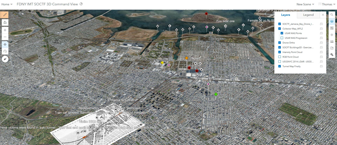

Real time data collection was performed during the initial response by operational personnel. Esri’s Collector application provided incident intelligence related to victim counts, damage assessment, and the area of operations.

Rapid Processing of LIDAR Data
Leica Geosystems provided two products that perform LIDAR modeling. One was deployed from fixed points throughout the operational area. The second was a backpack based model that personnel could “walk through” the incident area on a mobile device.

This data, creating a 3D model of the tunnel in near total darkness, could provide the command staff the ability to virtually fly through the tunnel within minutes of gathering the data. The LIDAR model identified areas of damage, vehicles, and victim locations.
The LIDAR data was shared through the IMT’s AGOL organization. This allowed the incident data to be accessed by any stakeholder that the command staff deemed appropriate.
UAS Data
FDNY UAS operators were able to provide imagery during the event. This imagery was integrated into the common operating picture. This provided responders with the most up to date site information possible.
The integration of all relevant data to produce a comprehensive picture of the incident was well received by the command staff. The FDNY has multiple operations personnel heavily engaged in the use of GIS products to improve safety and efficiencies in response operations. The FDNY has developed the capability to use mobile applications for field data collection. Operational personnel not directly involved in the use of GIS recognized its value during this operation. There was demonstrated capability in the IMT’s ability to use mobile applications and build Operations Dashboards to provide a common operating picture. The IMT GIS personnel are highly skilled in the use of GIS for emergency response.
Public safety agencies worldwide already have access to many of the capabilities used during this exercise. These capabilities are applicable to daily operations, disaster response, planning activities, and many other areas of public safety agency operations.
If you have any questions about deploying these capabilities for your agency, please feel free to contact Esri.
Mike Cox, Director of Fire & EMS Solutions mike_cox@esri.com.
You must be a registered user to add a comment. If you've already registered, sign in. Otherwise, register and sign in.