- Home
- :
- All Communities
- :
- Industries
- :
- Public Safety
- :
- Public Safety Blog
- :
- Esri Joins FirstNet for Inaugural Hackathon in San...
Esri Joins FirstNet for Inaugural Hackathon in San Francisco
- Subscribe to RSS Feed
- Mark as New
- Mark as Read
- Bookmark
- Subscribe
- Printer Friendly Page
- Report Inappropriate Content
By Mike King, Global Emergency Call Taking and Dispatch/FirstNet Industry Manager, Esri
Public safety officials around the world benefited from the collective attention and expertise of nearly 200 who gathered in San Francisco, California, on March 23 and 24, 2018, for the FirstNet Public Safety Hackathon. The event, created by FirstNet (and supported by AT&T), was sponsored by Esri, IBM, and Samsung. Each sponsor took part in providing developer software and technology along with skilled advisers, who offered one-on-one mentoring and technical assistance throughout the two-day event.
Hours before the event began, FirstNet revealed its application challenges to the group and stated that each challenge was created through a series of public safety discussions that had been held across the country. The use cases came from police officers, firefighters, and emergency medical personnel, who had focused on voice and data communications during major, multijurisdictional events. Esri was invited to sponsor the event because location information is a common element of every mobile technology-based solution. Given Esri's proven history as the maker of the GIS technology preferred by developers and end users, inviting Esri to this event simply made good sense.
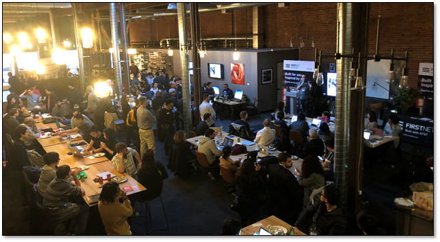
Developers from around the world listened to instruction by AT&T, Esri, IBM, and Samsung staff during the inaugural FirstNet Public Safety Hackathon, held at Covo in San Francisco, California, in March 2018.
Specifically, law enforcement attendees had requested "solutions that collect and synthesize data from disparate sources," with a goal of having location intelligence that leads to actionable decision-making. Firefighters had said they wanted tools that would assist them in creating preplans as well as provide real-time asset management, building schematics, and in-vehicle routing. The firefighters also mentioned the need for real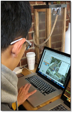 -time information about call status, emerging risks, and sensor data like traffic reports and weather conditions. Emergency medical responders had echoed the concerns of police and fire staff but added the need for solutions that "collect situationally relevant patient information for effective triaging [patients] and medical response" and provide real-time information for proper delivery of customized care, all while maintaining efficient records management for easy tracking and reporting. And all had agreed that any solution developed must be easy to deploy and use.
Throughout the night and into the following day, the developers consumed large volumes of caffeine and a never-ending pile of food and treats, taking catnaps whenever possible.
As the two-day marathon came to a close, the developers gathered to share their creative works and be judged. Those participating in the event challenged the status quo of public safety workflows and even cutting-edge technology.
The resultant applications showed promise, as evident by an application (shown) that was designed to locate and track firefighters in buildings, using 3D capabilities in ArcGIS. Other applications focused on citizen interaction with public safety staff as well as first-responder communication with dispatch, command, and control centers and emergency rooms.
With persistence, refinement, and the right amount of exposure, some of these apps could be in the quiver of tools used by frontline public servants in the future.
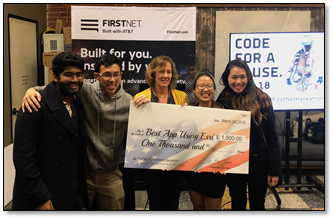
With cash awards totaling $28,000, interest, energy. and enthusiasm remained high throughout the 30-hour event.
Esri recognized team S-Rescue (Michelle S. Lee, Wei-Ting Yap, Anirudh Nair, and Yon Zheg Xi) with an award for the best use of ArcGIS technology. Their application demonstrated how 911 callers ("victims") or emergency personnel can be located inside buildings. They showed a 3D floor plan with victims and first responders as points on the map (color coded). In order to show updated locations and movement, the team took advantage of ArcGIS Online and configured a web scene, configuring it with ArcGIS API for JavaScript.
Would you like to learn more? Email Mike King at mking@esri.com or click one of these links:
• Esri Developer Tools
• Esri Startup Partner Program
• Esri Public Safety Solutions
• FirstNet Developer Ecosystem
You must be a registered user to add a comment. If you've already registered, sign in. Otherwise, register and sign in.