- Home
- :
- All Communities
- :
- Products
- :
- Mapping and Charting Solutions
- :
- Mapping and Charting Blog
- :
- Explore the past with the USGS historical topograp...
Explore the past with the USGS historical topographic map explorer!
- Subscribe to RSS Feed
- Mark as New
- Mark as Read
- Bookmark
- Subscribe
- Printer Friendly Page
- Report Inappropriate Content
There’s something wonderfully appealing about historical maps. Perhaps it is knowing how much work went into them – the time spent exploring and surveying, the attention required to manually draw and label features – that elevates maps beyond social, political, and scientific necessities. Maps of the past are works of art, which also contain valuable information about the history of places.
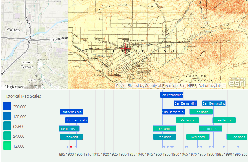
With today’s advanced technology, we no longer have to rely on reprints and museum displays to view maps from the pre-digital age. The USGS, in partnership with Esri, has released a Historical Topographic Map Explorer that allows you to view over 178,000 maps dating back to the late 19th century. Search for or pan to your location and dynamically view up to 130 years of cartographic records.
I could get lost (pun intended) in this site for hours. For example, searching on my hometown of Redlands, California brings up a timeline of maps dating back to 1901. After downloading a copy of the earliest USGS map of my area for closer inspection, I was amazed to see the suburban sprawl I am accustomed to was nothing but country roads and orange groves so long ago. On the website, the historical maps are placed right on top of the modern web map, and a slide bar on the left allows you to adjust the transparency for instant comparison.
Not only could this tool be useful for academic and analytical purposes, but on a personal level, it brings the past to life. I love being able to see how the little town my grandmother was born in has grown into the thriving development I know today. Cartography as an art and science has evolved drastically in the last century, and I am delighted to see the hard work and brilliant creations of our predecessors digitized and made available for viewing in such a vibrant, interactive format.
For a more in-depth look at the many features of the USGS Historical Topographic Map Explorer, check out this article on ArcWatch.
Have you used the USGS Topographic Map Explorer? What did you think? How has your location changed in the last century?
You must be a registered user to add a comment. If you've already registered, sign in. Otherwise, register and sign in.