- Home
- :
- All Communities
- :
- Products
- :
- ArcGIS Online
- :
- ArcGIS Online Blog
- :
- What’s New in ArcGIS Online (December 2017)
What’s New in ArcGIS Online (December 2017)
- Subscribe to RSS Feed
- Mark as New
- Mark as Read
- Bookmark
- Subscribe
- Printer Friendly Page
- Report Inappropriate Content
ArcGIS Blog by Bernie Szukalski
ArcGIS Online has just been updated with the following new features and enhancements. This release includes a more flexible user experience for managing and discovering content, Insights for ArcGIS, administrative enhancements, and other improvements throughout the site.
For additional information see the What’s new help topic or ArcGIS blog posts specific to this release.
*
User experience
Start Page
You can specify the start page that you first see when you sign in to your account. The setting is managed in your Profile.
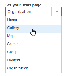
The specified page appears each time you sign in to your site. For example, set your start page to Gallery to go directly to your organization’s gallery page, or set your start page to Map to open the Map Viewer automatically after signing in. See Start page for details.
*
App Launcher
Administrators can now make web apps available to organization members by adding apps to the app launcher. The app launcher appears in the upper right next to Search after signing in.

Members can personalize their view of the app launcher by dragging and dropping apps to change the order in which they are displayed.
*
Item Status
Items can now be marked as authoritative or deprecated in the item settings. Administrators and content curators in your organization—those with privileges to update organization content—can now designate items as Authoritative. Users can deprecate items they own. Setting the status makes it easier for members of your organization to find reliable, authoritative items while discouraging the use of items that are not as reliable or becoming out-of-date. Items with these status indicators are identified by a corresponding badge on the item page.
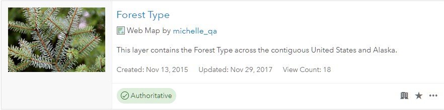
The Status filter can be used when members search or browse for content. Organization members can also restrict layer searches to authoritative layers when authoring maps using the Map Viewer. The Authoritative status is currently only visible within your organization, Deprecated status is also visible outside your organization.

*
Item information
A new status bar and interactive checklist on item pages help item owners and administrators improve item information, making it easier for others to find, understand, and use their items.
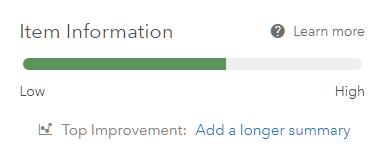
As item details are completed, the status bar shows the current item information completion status, and offers suggestions for improvement. See Item information for more details.
*
Mobile devices
ArcGIS Online has been enhanced to better support mobile devices. Open layers in Map Viewer using the new open link on the layer’s item page. Sign in with your enterprise or social network credentials and get help with your password and user name.
*
Insights for ArcGIS
Insights for ArcGIS is a web-based, data analytics workbench that allows you to perform iterative and exploratory data analysis. A new version is now available for ArcGIS Online, previously Insights was only available with ArcGIS Enterprise.
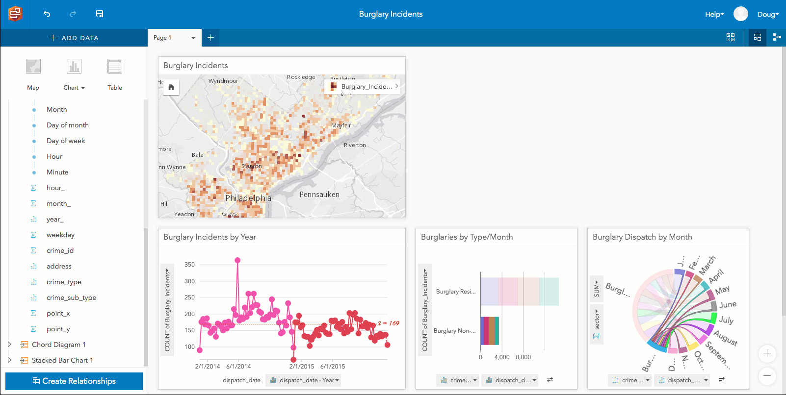
Using interactive linked cards, you can gain new discoveries about your spatial and nonspatial data. Linked cards allow you to click on a map or chart and see related data light up on another card. In the example above, crimes are explored by type, volume, and density to see if patterns change over time.
For more information, see the Insights for ArcGIS website or Insights for ArcGIS help.
*
Map Viewer
Map Viewer is a built-in app that enables you to view and author maps, navigate, see map details, edit, perform analysis, and more (depending on your privileges). New for this release:
Analysis tools include a new Find Centroids, allowing you to find the geometric center of multi-point, line, or area features.

Aggregate Points and Summarize Within have a new option to generate custom square or hexagon bins instead of summarizing your data within an input area layer.
Light up your map with a new Firefly symbol set. A firefly point symbol is a dot with a colorized glow effect, useful for creating dramatic thematic maps. These symbols are especially effective when used with the World Imagery (Firefly) basemap.
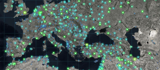
See more Firefly symbols and basemaps in the Living Atlas of the World.
You can now use geometric operations in Arcade expressions defined for smart mapping styles, labeling, and pop-ups. Use advanced functions to normalize by area, test spatial relationships, compute distances between defined areas, and more.
You can now update the URL of layers in your map from HTTP to HTTPS, or from staging versions of your ArcGIS service layers to production versions. This is available via the Settings tab for the map item. ArcGIS Online inspects each layer in the map. If any layers use HTTP, ArcGIS Online attempts to make a request to the same layer using HTTPS, and then updates the map and any associated layer items you own or administer. If a layer does not support HTTPS, you are notified and the layer URL is not updated. See Layer Settings for more details.
Arrows are now available to indicate direction when styling line features. See Change symbols for more information.
You can now add GeoJSON files to your map. GeoJSON is a widely used open standard format for encoding a variety of geographic data structures in JavaScript Object Notation (JSON) format. See Add layers from files.
*
Scene Viewer
Scene Viewer is an app built into ArcGIS Online for creating and interacting with 3D scenes. New for this release:
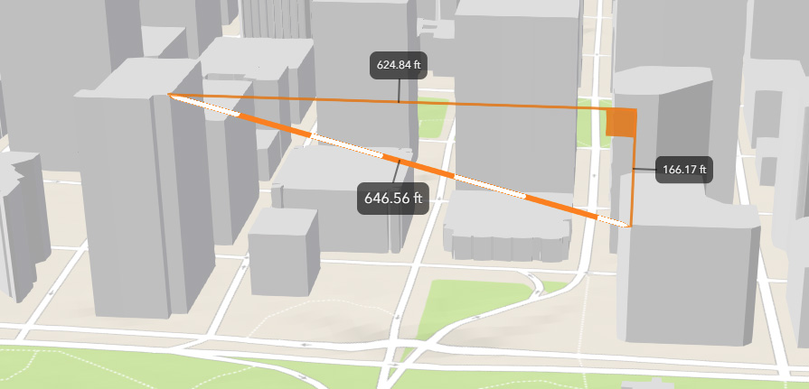
You can now measure distances in 3D between two points in Scene Viewer. Choose different measuring units and leverage interactive laser lines to calculate the direct and vertical distances in your scenes. See Measure your scene.
Scene layer performance has significantly improved in this release. Buildings and integrated mesh scene layers now load faster using the correct priority order. Additionally, when zooming to scene layers, data is temporarily cached enabling the layers redraw much faster.
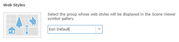
3D symbols from ArcGIS Pro can be used in your scene via style files published from Pro. In addition, organization Administrators can now configure custom web styles for Scene Viewer.
 Other enhancements in Scene Viewer include the inclusion of 3D ArcGIS Marketplace subscription content, and 3D mobile support (still in experimental phase).
*
Data collection & management
You can now use CSV and Microsoft Excel files stored in Microsoft One Drive and Dropbox to publish hosted feature layers. If you update the the data in the file on the cloud drive, you can overwrite the data in the hosted feature layer using the updated cloud data. Google Drive, including Google Sheets, will be supported soon after this initial release. For more information, see Add and publish files from a cloud drive.
Administrators and owners can now append data to layers in existing hosted feature layers without needing to overwrite the entire hosted feature layer.
You can now define an area of interest for hosted feature layer views to limit access to features within a particular area.
New editing options are available for hosted feature layers and hosted feature layer views, providing more fine-grained control over what operations editors can perform.

After enabling editing, choose the editing capability allowed on the feature layer. See Manage editor settings for details.
*
Living Atlas
ArcGIS includes Living Atlas of the World, a global collection of authoritative, curated content from Esri and the GIS community. Living Atlas is an integrated part of the ArcGIS platform, providing an easy way to access basemaps, maps, layers, and more covering thousands of topics.
Esri vector basemaps have been updated to include additional Esri Community Maps content and style refinements. New vector basemaps are also available. Shown below is Nova – a recently introduced vector tile layer that provides a detailed basemap for the world featuring a dark background with glowing blue symbology.

See the Vector Basemaps blog posts for more information on how to take advantage of these new basemaps. For more information on Nova, view the item details.
A new version of the SSURGO Downloader has been released, providing quick access to ready-to-use map packages filled with useful soil data with over 150 attributes derived from the SSURGO dataset.
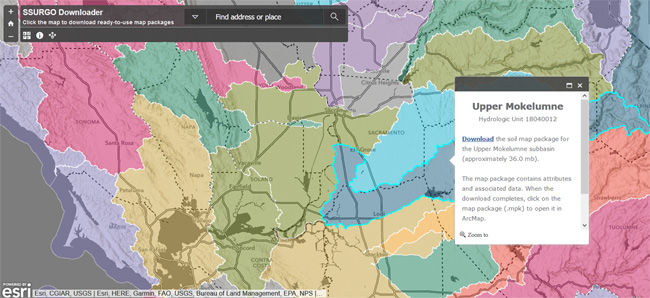
To use this application, navigate to your study area and click the map. A pop-up window will open. Click download, and the map package will be copied to your computer.
World Imagery basemap has been updated with additional sets of DigitalGlobe imagery for several countries, including sub-meter resolution Basemap +Vivid imagery for Australia and the United States. In addition, sub-meter resolution Basemap +Metro imagery has been published for a few hundred additional cities around the world.
Updates have been made to the demographic maps for Germany and several other countries. The demographic maps now feature the latest demographic data for Germany from Nexiga. In addition, updates have been released for several other countries using the latest Michael Bauer Research demographic data.
Detailed local boundaries, based on authoritative data from national government sources, have been published for a few countries. These boundary layers can be used for visualization and analysis in ArcGIS Online.
For the latest information, see the Living Atlas blog posts.
*
ArcGIS Hub
ArcGIS Hub is a platform for public engagement and citizen collaboration. It makes a smart community even smarter, giving context and purpose to data and organizing people, processes, and technology to meet the needs of citizens and governments.

ArcGIS Hub has recently been updated with the following:
Site and Page improvements include new cards that enable you to quickly and easily configure and customize your sites. Site Themeshave an improved editor, and now include 7 configurable theme options. Initiatives include better tools for managing and monitoring team members, and improvements to the Community Dashboard. Citizen Perspectives enable community members to sign-in to your Hub to analyze data and contribute local perspectives. Finally, Hub now supports 31 languages, and includes accessibility and mobile device improvements.
For more information, see ArcGIS Hub updates for December 2017.
*
Administration
Custom roles include the privilege to link to enterprise groups. To take advantage of the new privilege in existing custom roles, edit the role, add in the new privilege, and save the role.
Members with Level 1 accounts can now join external groups if assigned to a custom role granting this privilege.
Members who have the privilege to update member account information can now also reset passwords for other members. Resetting passwords is no longer a privilege reserved for default administrators.
A new setting allows administrators to prevent all ArcGIS Pro licenses in the organization from being taken offline.
The invitation process has been improved; you can now enable Esri access when inviting and adding members. A member whose account has Esri access enabled can use My Esri and GeoNet Community and Forums, access e-Learning on the Training website, and manage email communications from Esri.
Organizations can now create groups whose membership is controlled by SAML-based enterprise groups.
*
App builders
App builders enable anyone to to build compelling applications, no coding required. App builders have been updated with the following enhancements:
*
AppStudio for ArcGIS
AppStudio for ArcGIS lets you convert your maps into consumer-friendly mobile apps ready for Android, iOS, Windows, Mac OS X, and Linux, and publish them using your own brand to all popular app stores – no developer skills required. See Palm Springs Map Tour as an example.
AppStudio has released major enhancements across the board, including an improved user interface for desktop tools and additional features in templates. AppStudio now uses Qt 5.9.1 and supports ArcGIS Runtime 100.1. For more information, see What’s new in AppStudio for ArcGIS.
*
Story Maps
Story Maps let you combine authoritative maps with narrative text, images, and multimedia content, making it easy to harness the power of maps and geography to tell your story. Continuing commitment to the Web Content Accessibility Guidelines 2.0, additional accessibility improvements have been made to Story Map Journal.

You can now specify alternative text for your story’s media, plus new heading tags and landmarks provide better semantic structure for assistive technologies. Further improvements have been made to the keyboard navigation controls added in the September 2017 update. For more information, see the Story Maps blog posts.
*
Web AppBuilder for ArcGIS
Web AppBuilder offers a way for you to easily create HTML/JavaScript apps that run on any device, using a gallery of ready-to-use-widgets. You can customize the look of your apps with configurable themes, and can host your apps online or on your own server.
Web AppBuilder now adds two new widgets and several enhancements to existing widgets. The new Cost Analysis (beta) allows you to sketch a proposed design and get an estimated cost of the project. Use the new Public Notification to define a collection of properties and create mailing labels for the owners or occupants. End-users can now build their own filter expressions with Filter. Filter expressions now support relative dates such as today and last week. Infographic has eight new templates and now supports custom colors.
Other widget enhancements include support for local KML in Add Data, layer visibility in Bookmark, layer selection control in Select, layer selection and zoom to the swipe layer in Swipe, and saving all edits to attributes with one commit in Edit.
For more information, see What’s new in Web AppBuilder for ArcGIS.
*
Configurable apps
Configurable apps allow you to choose from a comprehensive set of templates to quickly author an app. For this release, the configuration pane in configurable apps has improved validation. For more information, see the configurable apps blog posts.
*
Apps for the field
ArcGIS field apps help you improve coordination and operational efficiencies in field workforce activities. Field app enhancements since the last ArcGIS Online update include the following:
*
Collector for ArcGIS
Collector for ArcGIS enables your field workforce to use smartphones or tablets to collect and update information in the field, whether connected or disconnected. Collector has updated since the last ArcGIS Online release with the following:
- Trimble Catalyst is supported on Android, allowing you to use Trimble’s new subscription-based software GNSS receiver capable of collecting data at centimeter accuracy.
- For organizations that require their accuracy be calculated using a 95 percent confidence interval, you can require the same in Collector.
- Collector’s custom URL scheme lets you include information to start a collection when launching Collector.
For more information, see What’s new in Collector for ArcGIS
*
Operations Dashboard for ArcGIS
Operations Dashboard for ArcGIS is an app that enables you to monitor, track, and assess your assets and daily operations.
Operations Dashboard for ArcGIS now supports authoring dashboards in the browser. Configure highly interactive dashboards composed of charts, gauges, maps, and other visual elements. Use better maps, with support for smart mapping, stream layers, and labels. Create powerful layouts with grouping and stacking. Get revamped data visualizations and improved date-based filtering. Manage your dashboards in the dashboard home page. For more information see Operations Dashboard for ArcGIS.
*
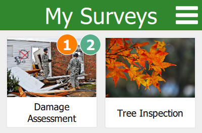
Survey123 for ArcGIS
Survey123 for ArcGIS is a simple and intuitive form-centric data gathering solution that makes creating, sharing, and analyzing surveys possible in three easy steps.
Survey123 has had an incremental release since the last ArcGIS Online update. The release features the following:
Survey123 Connect now includes the ability to add fields to an existing feature service, disable the Sent box, and ensure fields are created in the feature service for note questions. Camera zoom has been added to image capture in the field app and barcode scanning defaults have been improved.
The Survey123 website has been partially redesigned to provide a more intuitive, user-friendly experience. The website now includes support for modifying field names, the ability to delete a survey without deleting the associated feature service, and support for nested repeats and groups, as well as having improved performance for custom reports.
For more information, see What’s new in Survey123 for ArcGIS.
*
Workforce for ArcGIS
Workforce for ArcGIS is a mobile solution that uses location-based decision making for better field workforce coordination and teamwork. It is composed of a web app used by project administrators and dispatchers in the office, and a mobile app used by mobile workers on their devices.

Workforce released an update focused on enhancing communication between Workforce and other apps, and between dispatchers and mobile workers. You can configure your Workforce project so that information provided in the assignment can be passed to Collector for ArcGIS or Survey123 for ArcGIS when launching those apps through Workforce.
Mobile workers can add attachments while they are working in the field, and dispatchers can access those attachments through the website. Dispatchers now see the date an assignment last changed state, showing how recently assignments have progressed. Project owners now have better ways to identify project members who are no longer part of the organization.
For more information, see What’s new in Workforce for ArcGIS.
*
Apps for the office
ArcGIS Apps for the Office enable you to put powerful, user-friendly tools and data into the hands of data analysts to gain location-based insights and make decisions that save money and time. Some apps for the office have been updated, highlights include the following:
*
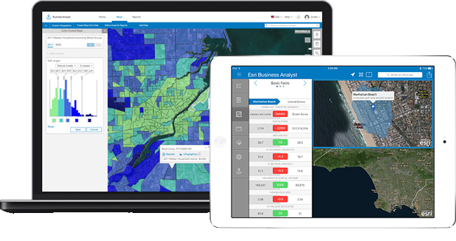
ArcGIS Business Analyst
ArcGIS Business Analyst helps you make smarter market planning, site selection, and customer segmentation decisions by combining demographic, lifestyle, behavioral, and spending data, maps, infographics and reports with analytics.
Business Analyst Web App now allows you to set validation on location attributes. Setting validation on location attributes helps you apply specific constraints on the site attribute values, and control what kind of data your field users capture. For example, prospective locations must have greater than 100 parking spaces or the building condition should be chosen from a drop down with options – good, average, poor.
This will be possible to set up while creating projects in the Business Analyst Web App. Both Business Analyst Web and Mobile apps will honor the validations defined and show informative messages when the entered numerical value is out of the defined range, or not in the dropdown options for text fields.
There’s also a new Executive Summary infographic template, and the ability to use maps in custom reports, plus enhancements throughout the user experience. For more information, see Business Analyst Web App What’s New.
*
ArcGIS Maps for Power BI
ArcGIS Maps for Power BI geo-enables Microsoft Power BI with spatial analytics, and offers enhanced mapping capabilities, demographic data, and more visualizations. The latest update introduces the new Plus subscription feature. Upgrading to a paid monthly Plus subscription allows you to add enhanced content and capabilities, including higher geocoding limits, more basemaps, global demographics, and access to Esri Living Atlas maps and layers to use as reference layers. For more information, see ArcGIS Maps for Power BI.
*
ArcGIS Maps for Adobe Creative Cloud
ArcGIS Maps for Adobe Creative Cloud is intended for design and communications professionals, delivering access to data-driven maps inside Adobe Illustrator and Photoshop.
You can now sign in to ArcGIS Online using your enterprise login or use your email address to access ArcGIS Maps for Adobe Creative Cloud as an anonymous user. Anonymous users have access to all public content hosted on ArcGIS Online. You now also have more control over the use of layers; you can manage labels to improve the overall appearance of your map and add or modify existing filters (definition queries) to refine what data is visible, based on attribute queries. New, large-scale vector content for the United States and the world is available, and you can now download CSV and TXT file data into the compilation window. For more information, see the ArcGIS Maps for Adobe Creative Cloud help.
*
Drone2Map for ArcGIS
Drone2Map for ArcGIS turns your drone into an enterprise GIS productivity tool by enabling you to create orthomosaics, 3D meshes, and more from your drone-captured still imagery.
Drone2Map has been updated with new features and performance improvements. The latest release adds the ability to create compressed zLAS point clouds, rolling shutter correction, GCP photo support, Integrated Windows Authentication, and flight altitude adjustment tools. For more information, see the Drone2Map for ArcGIS help.
*
Other enhancements
ArcGIS Runtime app developers can now prepare map areas ahead of time for offline use. This provides a faster and more streamlined offline experience.
Slovenian is now a supported language in the website.
*
For more information about the December 2017 release
For more information see the What’s new help topic or ArcGIS blog posts specific to this release.
You must be a registered user to add a comment. If you've already registered, sign in. Otherwise, register and sign in.