- Home
- :
- All Communities
- :
- Products
- :
- Imagery and Remote Sensing
- :
- Imagery Blog
- :
- Resources for access to frame camera imagery
Resources for access to frame camera imagery
- Subscribe to RSS Feed
- Mark as New
- Mark as Read
- Bookmark
- Subscribe
- Printer Friendly Page
- Report Inappropriate Content
Do you have imagery from an aerial photography camera (whether a modern digital camera or scanned film) and the orientation data either by direct georeferencing or the results of aerial triangulation? If yes, you’ll want to work with a mosaic dataset, and load the imagery with the proper raster type.
The mosaic dataset provides the foundation for many different use cases, including:
- On-the-fly orthorectification of images in a dynamic mosaic, for direct use in ArcGIS Pro or sharing through ArcGIS Image Server.
- Production of custom basemaps from source imagery.
- Managing and viewing aerial frame imagery in stereo.
- Accessing images in their Image Coordinate System (ICS).
There are different raster types that support the photogrammetric model for frame imagery. If you have existing orientation data from ISAT or Match-AT, you can use the raster types with those names to directly load the data (see Help here).
For a general frame camera, you’ll want to know how to use the Frame Camera raster type and we have recently updated some helpful resources:
- We’ve published a ‘best practices’ document at http://esriurl.com/FrameCameraBestPractices that provides a comprehensive overview of many different scenarios.
- We’ve also updated resources on the Imagery Workflows site to provide working examples you can follow. These resources start at this link http://esriurl.com/FrameCameraSample and will lead you to 2 different examples:
- First is the Manual workflow sample http://esriurl.com/FrameCameraManualSample if you’d like to see the “deep dive” details for how this raster type works.
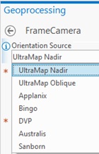
- The second is the Automated sample script http://esriurl.com/FrameCameraAutomatedScript that provides support for ingestion of aerial triangulation project files from Bingo, Vexcel Ultramap, DVP PAR, Australis, and Sanborn.
Further information:
- Note that if your imagery is oblique, the Frame Camera raster type supports multi-sensor oblique images. Refer to the http://esriurl.com/FrameCameraBestPractices for configuration advice.
- If you want to extract a digital terrain model (DTM) from the imagery, or improve the accuracy of the aerial triangulation, see the Ortho Mapping capabilities of ArcGIS Pro (advanced license). http://esriurl.com/OrthoMapping.
- If you are seeking additional detail on the photogrammetric model used within the Frame Camera raster type, see this supplemental document http://esriurl.com/FrameCameraDetailDoc
You must be a registered user to add a comment. If you've already registered, sign in. Otherwise, register and sign in.
-
Analysis
10 -
ArcGIS Drone2Map
3 -
ArcGIS Excalibur
1 -
ArcGIS Image Analyst
1 -
ArcGIS Image for ArcGIS Online
1 -
ArcGIS Pro
1 -
Change detection
1 -
Deep learning
4 -
Elevation and lidar
8 -
Image classification
1 -
Image management
2 -
Image Mapping
8 -
Image Services
3 -
Mosaic datasets
4 -
Motion imagery
10 -
Multidimensional
2 -
Oriented Imagery
2 -
Raster functions
4 -
Site Scan for ArcGIS
1 -
Visualization
9
- « Previous
- Next »