- Home
- :
- All Communities
- :
- Products
- :
- ArcGIS GeoEvent Server
- :
- ArcGIS GeoEvent Server Blog
- :
- Can I use the GeoEvent Simulator to simulate event...
Can I use the GeoEvent Simulator to simulate events with geometries other than Point
- Subscribe to RSS Feed
- Mark as New
- Mark as Read
- Bookmark
- Subscribe
- Printer Friendly Page
- Report Inappropriate Content
Hey All -
Normally the GeoEvent Simulator loads comma separated text from a simulation file and allows you to send this data to a GeoEvent Server tcp-text-in input to simulate a real-time data feed. Sample data in the tutorials either represents a point geometry as a quoted pair of X,Y coordinate values (e.g. "-75.175,39.991") ... or provides the coordinates of a point location as separate X and Y attribute values which the input can take and use to construct a geometry.
But what if you want to simulate a dynamic polygon, such as a series of forecast areas affected by a storm?
Here's a trick you might find handy:
- You do not have to use a comma to delineate your event attributes in a simulation file.
- Valid Esri Feature JSON can be placed in a simulation file.
- A GeoEvent Server input can be configured to interpret the JSON as a geometry.
Consider the following two lines of simulation input:
"AA-1234";"12/24/2015 23:59:59";{ "rings": [ [ [-75.175, 39.991], [-75.173, 39.991], [-75.173, 39.99], [-75.175, 39.991], [-75.175, 39.991] ] ], "spatialReference": { "wkid": 4326 } }
"BB-7890";"02/15/2015 12:34:56";{ "rings": [ [ [-8368449.66, 4864715.92], [-8368263.15, 4864676.62], [-8368272.04, 4864618.25], [-8368459.87, 4864645.20], [-8368449.66, 4864715.92] ] ], "spatialReference": { "wkid": 102100, "latestWkid": 3857 } }
In both examples I am sending GeoEvent Server a JSON string representation of a geometry using the Esri Feature JSON format for a polygon geometry. Please refer to the ArcGIS Developers on-line documentation for the JSON spec and samples of Point, Multipoint, Polyline, and Polygon geometries.
Notice that I have chosen to separate the event attributes using a semi-colon rather than a comma. Since both commas and literal quotation marks are part of the Esri Feature JSON syntax, using a semi-colon for field delineation simplifies my simulation file considerably. It allows me to keep the required quotes and commas without having to escape or quote them as string literals. I'm free to quote the other event attributes of the simulated event. In the examples above, I've quoted my TRACK_ID and my TIME_START values, though I probably do not need to.
Also notice that each geometry string includes the coordinate system associated with the coordinate values. The first event uses the WGS 1984 Geographic Coordinate System (its coordinate values are expressed in decimal degrees). The second event uses the Web Mercator Aux Sphere Projected Coordinate System (its coordinate values are expressed in meters).
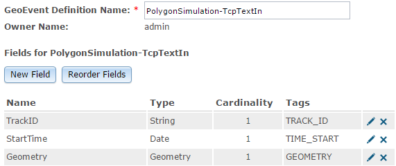
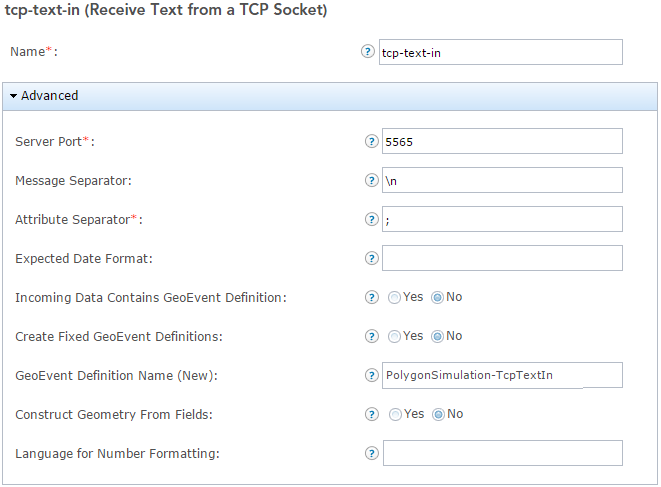
Attached are illustrations of the GeoEvent Definition I configured my 'Receive Text from a TCP Socket' input to use. The input is still responsible for adapting the delimited text it receives from the GeoEvent Simulator, so it needs to know what characters to expect for the message separator and attribute separator ... and it relies on an event definition to tell it that the third attribute should be interpreted as a Geometry.
If you try this and run into problems, let me know. There may be limits on the raw number of bytes you can pass over a TCP socket or how many messages of a given size you can load into the GeoEvent Simulator and send each second. It is probably best to simplify string representations of your geometries when including JSON in simulated event data.
Hope you find this information useful -
RJ
GeoEvent Definition
GeoEvent input configuration
You must be a registered user to add a comment. If you've already registered, sign in. Otherwise, register and sign in.