- Home
- :
- All Communities
- :
- Events
- :
- FedGIS Conference
- :
- FedGIS Conference Blog
- :
- FedGIS 2017 Day Two Updates: Why Birds Love the Sc...
FedGIS 2017 Day Two Updates: Why Birds Love the Science of Where, Living Atlas, Spatial Clusters
- Subscribe to RSS Feed
- Mark as New
- Mark as Read
- Bookmark
- Subscribe
- Printer Friendly Page
- Report Inappropriate Content
Welcome to Day Two of the FedGIS coverage and story sharing here on the GeoNet Community! We hope you enjoyed Day One and we're excited to dive into today's events, sessions and workshops.
ArcGIS Insights Workshop
To start the day, in one of the morning workshops, Linda Beale and Art Haddad, took us through an intro to ArcGIS Insights. Lots of good questions were asked by attendees including one popular question about being able to do cross-database joins. Many hands were raised when Linda asked how important that was and she appreciated the feedback and was going to consider it for future releases. Contribute to the workshop conversation here.
Why Birds Love the Science of Where: National Audubon Society Keynote

Next, it was time to fly in for the morning keynote from David Yarnold, CEO and President of the National Audubon Society, who shared how they transformed their organization into a more collaborative network with GIS and the Science of Where. Here's a collection of highlights and takeaways.
Jack welcomed us and introduced the keynote with this video sharing the National Audubon Society story.

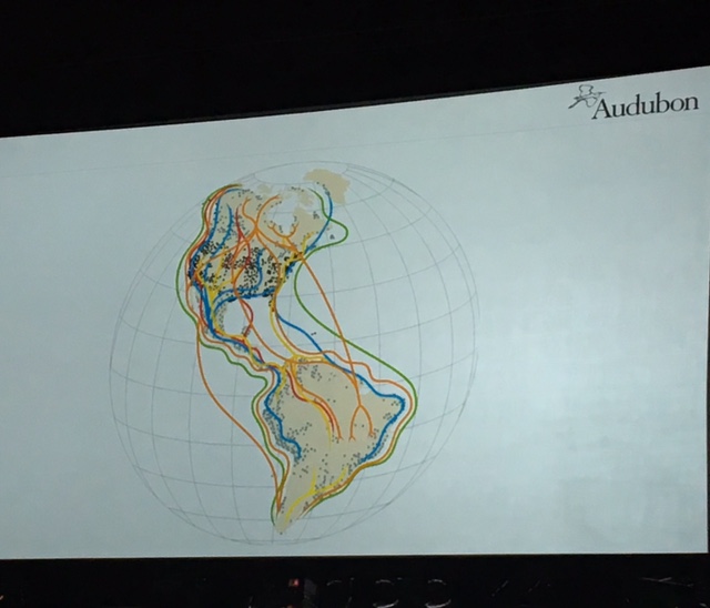
In the past, the NAS didn't have a clear vision of the impact and influence of their work. So using the global map image below, David began to help his team transform how the NAS saw itself and understand the global impact of their work.
David, a former leader at the San Jose Mercury news, told a story about how when an oil spill happened in San Jose they used an old base map and just wrote "oil spill on it" in an area that wasn't correct or geographically accurate. He said this was a key moment that inspired and reminded him of why his team needed to leverage the Science of Where in their work.
David shared that "If you take care of birds, you can take care of the worlds biggest problems" and using GIS and maps empowered his team to communicate this powerful message both to their own organization and the world. "GIS takes ideas out of your head and puts them on the table. When we can all look at it together we can iterate shared visions of the future."
David shared that as they begun to create "a conversation network," their organizational change "aha moment" was driven by GIS in three ways:
- Sophisticated conversation planning
- Collaborate workspace
- Authoritative, shared data
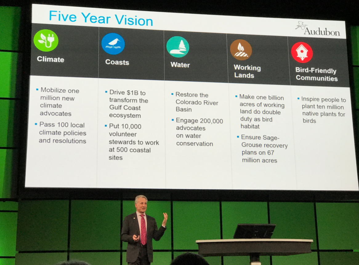
David shares the five year vision for the National Audubon Society:
Sharing insight from his journalism and media background, David highlighted the importance of using compelling GIS data to engage the media to get the word out about important issues and tell more compelling stories in the press.
Demonstrating the power of GIS and maps to create real change David shared how this story map about the Piper Polver helped turn a map and data into policy.
It was a great keynote and we'd love to hear what you thought. Share your comments below!
National Mapping and Imagery Workshop
After the keynote, I swung by the "National Mapping and Imagery: See the Earth, Find the Patterns, and Share the Knowledge" workshop as Mark Romero and Kurt Schwoppe from Esri they explained and demoed how drones, imagery and photogrammetric production in ArcGIS online and Drone2Map is being use to update historical images and enhance current data sets. The use cases highlighted the importance and challenges of collaboration, and how the combination of tech helped local and federal agencies recover from Hurricane Matthew and cast a vision for improving roadways and infrastructure projects. We invite you to continue the workshop conversation here.

Spatial Data Mining I: Essentials of Cluster Analysis workshop
I enjoyed checking out the Spatial Data Mining I: Essentials of Cluster Analysis" workshop hosted by Lauren Bennett and Flora Vale. Using examples of car crime in local communities, they shared helpful details, insights and live demos about the value of doing thoughtful cluster analysis and highlighted how they incorporated the Getis-Ord Gi* Statistic into the hot spot tool set. We invite you to continue the workshop conversation here.


ArcGIS Online Content - Building a Living Atlas of the World workshop
The world (and its digital twin) is always changing and during the Building a Living Atlas of the World session, Sean Breyer and Deane Kensok from the Esri team, showed how the Living Atlas platform gives users a broad set of tools to use. They shared the depth of the Living Atlas content portfolio (image below) and how big of a role the tools are playing in helping users keeping their imagery data updated and how precise the new imagery tools is. For example, as seen in the image below, the Living Atlas images are can be so precise that you can see the shadows clear enough to tell that baseball players are left and right handed. And this helps users create better maps and data sets. Check out the livingatlas.arcgis.com to get started. We invite you to continue the workshop conversation here:FedGIS Discussion: ArcGIS Online Content - Building a Living Atlas of the World


And that's a wrap! Thanks for following along on the updates during the FedGIS 2017 Conference. We had a great time connecting and collaborating with you. Let's continue the conversation! Check out other discussions about the events and workshops, start new discussion and ask questions in the FedGIS Conference space.

You must be a registered user to add a comment. If you've already registered, sign in. Otherwise, register and sign in.
-
FedGIS 2017
4 -
FedGIS 2018
5 -
FedGIS 2019
1 -
FedGIS 2020
3 -
FedGIS 2021
4 -
FedGIS 2023
4 -
FedGIS 2024
3