- Home
- :
- All Communities
- :
- Industries
- :
- Education
- :
- Education Blog
- :
- Using GIS to Create and Give Quizzes
Using GIS to Create and Give Quizzes
- Subscribe to RSS Feed
- Mark as New
- Mark as Read
- Bookmark
- Subscribe
- Printer Friendly Page
- Report Inappropriate Content
I am frequently asked by the education community, "How can GIS be used to create quizzes that are interesting, that foster spatial thinking, that provide benefits to students and instructors?"
Let me begin by stating that I am especially keen on using quizzes if their primary benefit is to help students learn and provide students with a way to reflect upon their own progress. I am less keen on quizzes that only benefit the instructor. Research in a wide variety of disciplines from physiology to geography affirms the value of quizzes that enhance student learning as the objective.
The kind of teaching and learning that working with GIS fosters is best measured, I believe, by such means as (1) evaluating a portfolio of student work, which could include story maps, reports, and other documents that they assemble into a story map collection or other set of digital documents; (2) evaluating student asynchronous or synchronous presentations using a variety of media in a face-to-face or online course environment, where the student presentations may include you, the instructor, but also their peers, and even other students in a “colloquium” type of session; (3) map-based assessments that may or not include a rubric (such as these examples from the University of Minnesota).
That said, quizzes still have their place in education. Research affirms the value of quizzes that use interactive and engaging multimedia, which is exactly what GIS offers. With some creative thinking, GIS tools and spatial data can be effectively used to create and administer quizzes. These quizzes can be used in teaching about GIS, such as in a GIS, remote sensing, or GI Science course, or in teaching with GIS, in geography, sociology, environmental studies, history, mathematics, or other disciplines. You can either screen shot specific map content and use those shots in your Learning Management System, PDF, PowerPoint, or other means, or you can create them in an interactive mode that takes advantage of web GIS technology such as ArcGIS Online. In this essay, I provide examples of both. I welcome your comments and look forward to seeing what you have created.
1. Quizzes About Content and Skills. The attached "week 3 quiz" document is an example of the type of quiz that I have found most effective over the years in instruction. In multi-week courses, I give one of these types of quizzes at the end of each week. I have found such quizzes effective because (1) they are short, (2) they include a few questions on skills (GIS, presentation, data), a few questions on content (in this case, it is part of a cartography and geo-visualization course, so the content includes color theory, classification methods, and the like), and 1 question on "what was the most significant thing you learned this week, and why?", and (3) they are designed so that the student can focus on the important elements of that week and reflect on their own learning and progress.
2. Landforms Quiz using Esri Base Maps. Let's a traditional quiz that is based on a resource that I and other earth science instructors used for decades, the Set of 100 Topographic Map Features. See attached for this quiz. Using the USA Topo maps layer in ArcGIS Online, which are derived from USGS topographic maps, you can capture any landforms that you wish to quiz students on. See the attached matching exercise focused on some really fascinating landforms—tombolos, karst, drumlins, and more. Another wonderful aspect about the topographic maps layer is that you have access to three scales: 1:24,000-scale, 1:100,000-scale, and 1:250,000-scale. A natural extension of this activity is to use the 3D scene viewer in ArcGIS Online as you give a geomorphology quiz.
3. Imagery. Imagery captivates and inspires, and makes excellent basemaps from which you can create quizzes about issues, current events, phenomena, places, past processes, and current processes active on the landscape. These include hurricanes, volcanism, fluvial processes, agricultural expansion, glacial retreat, urbanization and urban forms, coastal and soil erosion, and much more. The ArcGIS platform, including the ArcGIS Living Atlas of the World, gives you access to a wide variety of imagery—UAV, Lidar, Sentinel-2, Landsat, high resolution current and historical visible imagery, and much more.
4. Pattern Recognition. Another type of quiz is to ask students to identify the pattern where they have to make a hypothesis of the variable that is being mapped. I created the following choro-quiz (choropleth quiz) as an example: https://community.esri.com/community/education/blog/2015/05/15/the-choro-quiz Given the vast number of maps in ArcGIS Online, including, again, the ArcGIS Living Atlas of the World, there will be no shortage of maps you can use, for your country or for the world. You can start with world countries and then include some choropleth maps on administrative units (states, provinces, regions) within your own country. To make the quiz more challenging, consider zooming to your own city and mapping certain variables at the census tract, enumeration district, block group, or other statistical area appropriate for your part of the world. Business Analyst Web, with its hundreds of variables including fascinating data on consumer behavior, makes another excellent source for such a quiz. See if you can identify the variable among the three choices given in each; for example, the quiz begins with this question: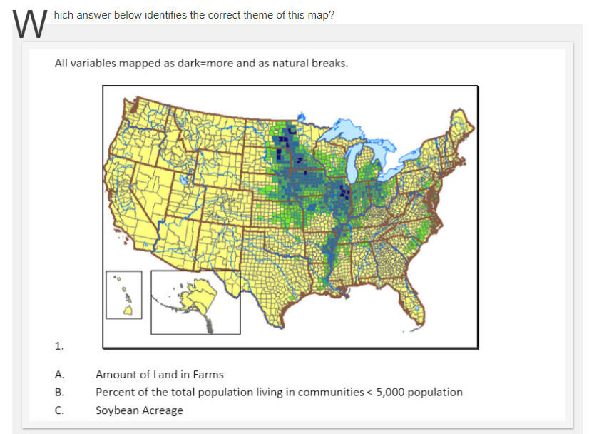
Part of the choro-quiz. Do you know what the answer is?
5. Using the ArcGIS Online Presentation Mode. ArcGIS Online includes a presentation mode that is simple and effective at creating quizzes. In a matter of minutes, you can create your own, using your own maps, or maps already in ArcGIS Online, with text for the clues and answers. Here are several examples that I created that I hope provide some ideas: Name That Place includes natural places (such as famous waterfalls) and human-built places (such as cities with famous river and street patterns). I created another quiz using this presentation mode focused on world islands, as well as this one focused on fun and interesting facts about 10 state capitals in the USA. In each of them, I provide the answers. A variation on this theme is my presentation quiz entitled Weird Earth, and as the name implies, it is designed to test student knowledge as well as foster curiosity about our amazing planet. Again, answers are provided.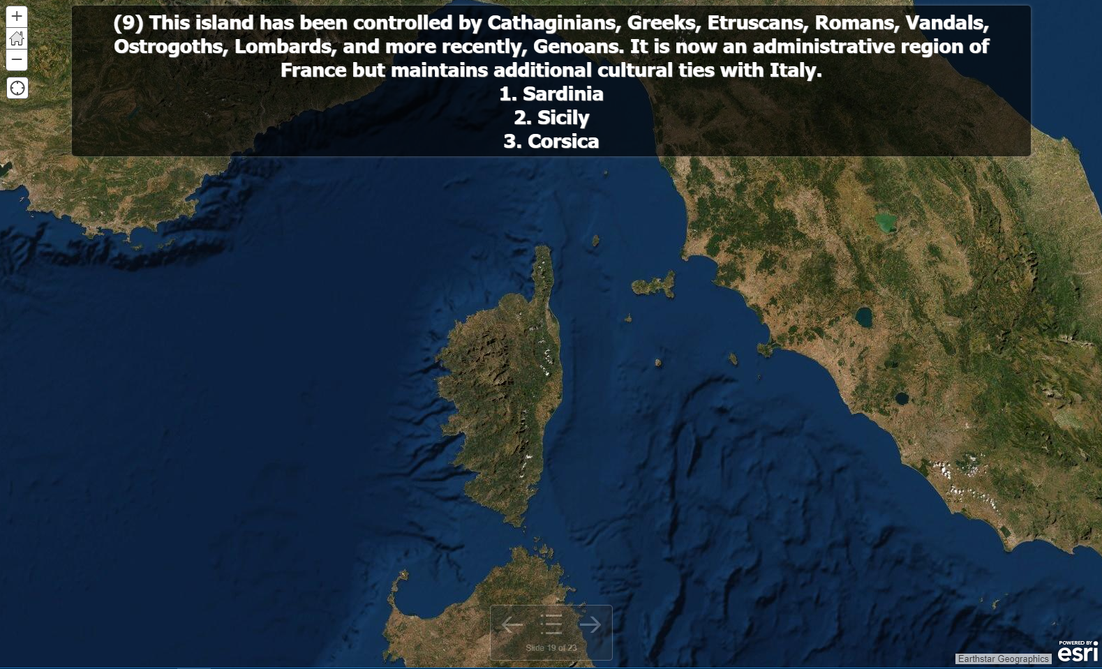
Part of the World Islands quiz, using the ArcGIS presentation mode.
6. Use Multimedia! Today’s modern ArcGIS platform can incorporate multimedia, so don’t feel confined to maps and images only. For example, my sounds of Planet Earth includes a quiz on 100 sounds, from pounding waves to crunching leaves, fr.... You could effectively use video, or images, as well!
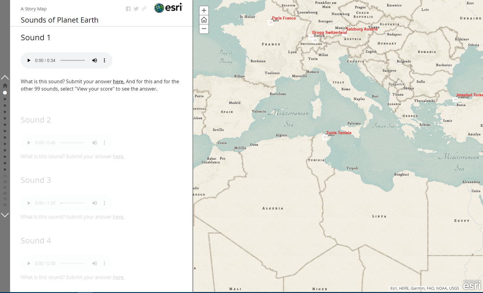
Part of the 100 Sounds of Planet Earth story map.
7. Photographs Tied To Maps. From time to time I create and use photographs tied to maps for quizzes to foster spatial thinking and considerations about landforms, vegetation, climate, and human impact, such as this Colorado Geography Quiz. I embedded this quiz inside a story map. Here is a similar one I created for a presentation I gave in California. And another one with 8 points and photographs in Wyoming.
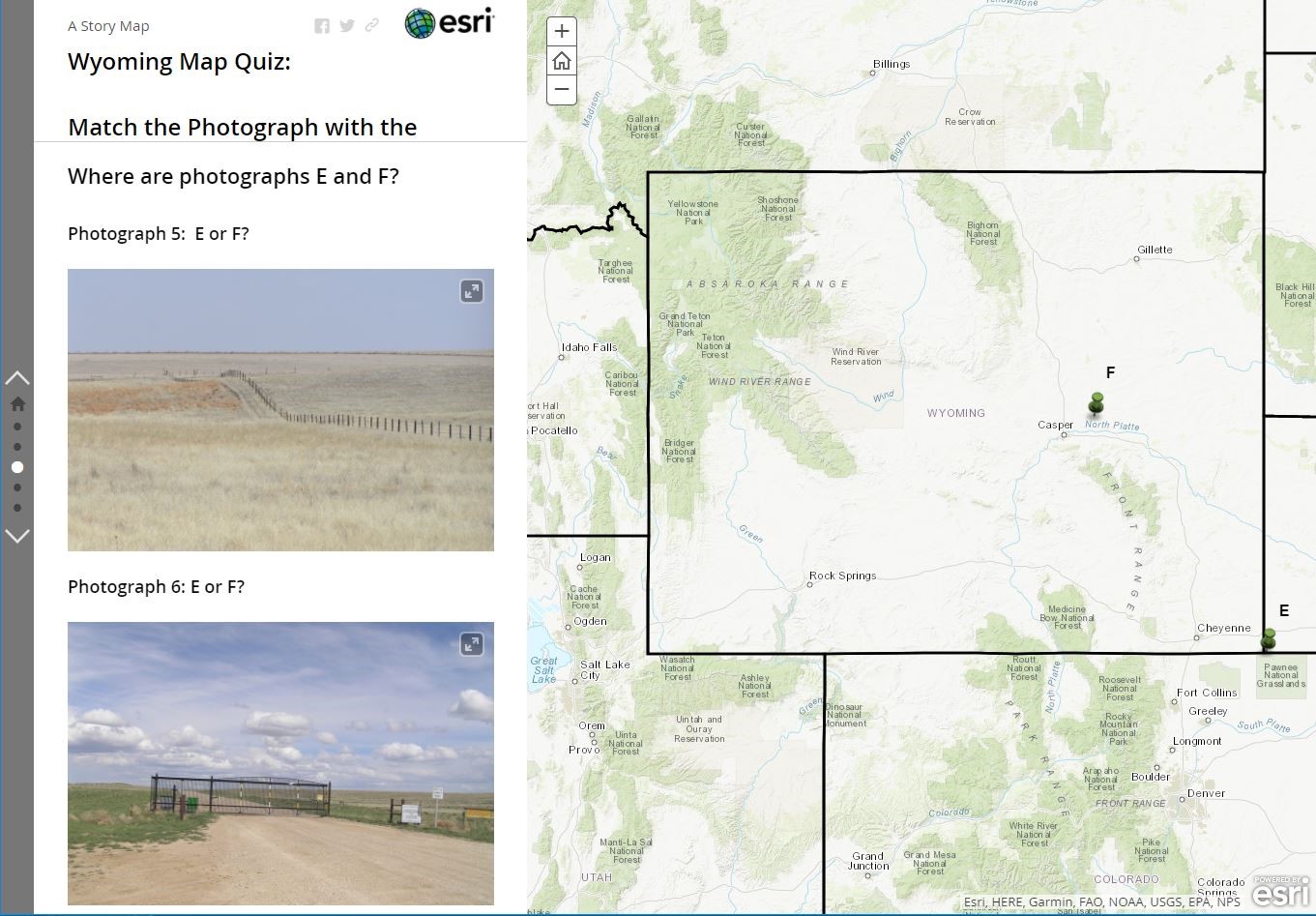
Part of a quiz asking participants to match the correct-photo to the correct location, in Wyoming, as part of a story map.
I occasionally use Street View images for these types of quizzes, asking students to identify the place based on what they can observe on the physical and cultural landscape. However, I don’t have permission from Google for the images yet, and if I developed additional ones similar to this, I would seek permission or use Mapillary or my own images for the source.
8. The Platform Approach. When you are using ArcGIS, you are using a platform. Combine elements of that platform for some very creative quizzes. As one example, you could create and use a Survey123 as a quiz, and you can embed that quiz inside a story map. This is what the Port of Tacoma did for GIS Day 2018 – Survey, here. My colleague Tom Baker used Survey123 and Google Forms for these quizzes, and also for this one on time zones, which are a part of a discussion on programmed instruction. Along these lines, here is one of my own Google forms to test geography about coordinates and GIS.
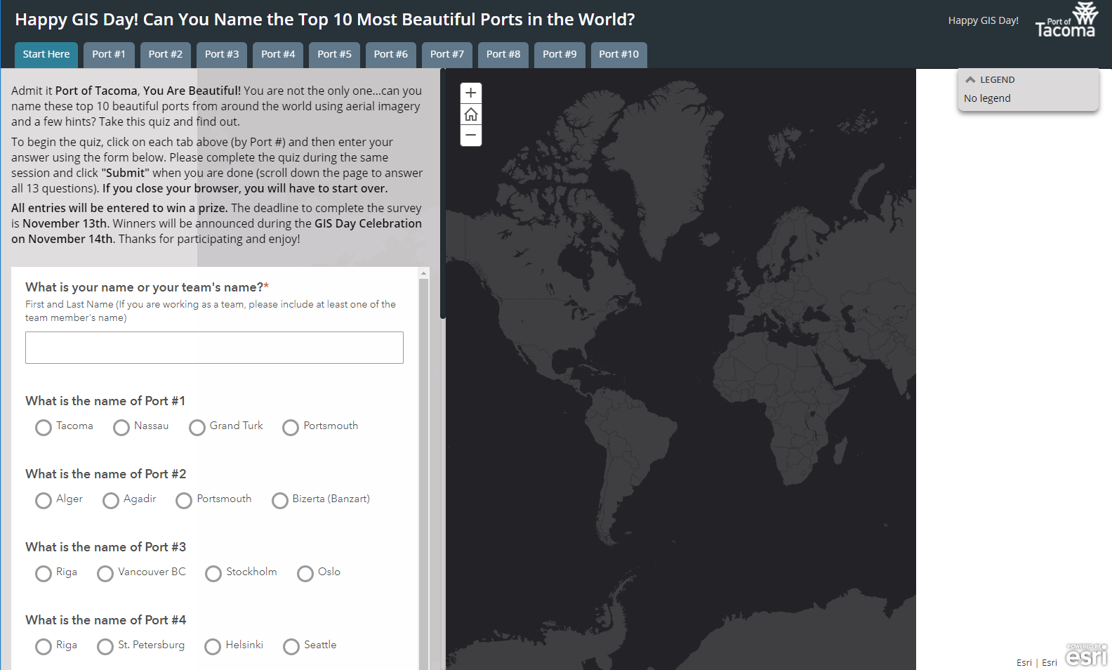
A section of the Port of Tacoma’s quiz about famous ports of the world, with a survey embedded inside a story map.
9. Treasure Hunts. As another example, with the help of the story maps team, I created a quiz on the pioneers of Geography and GIS, for GIS Day and beyond. I provide the quiz here to spark ideas, but keep in mind that this was a custom application and is not replicable in exactly this same way. Each question focuses on a geography or GIS pioneer and hints at a location somewhere in the world where the pioneer was born or worked. To answer the question, you must frame the solution within the map viewfinder using the map's pan/zoom functions.
Intrigued? Consider using these other quizzes in the “Treasure Hunts” theme. Here is a collection of 10 treasure hunt quizzes … beaches, mountains, cities, places, foods, and more.
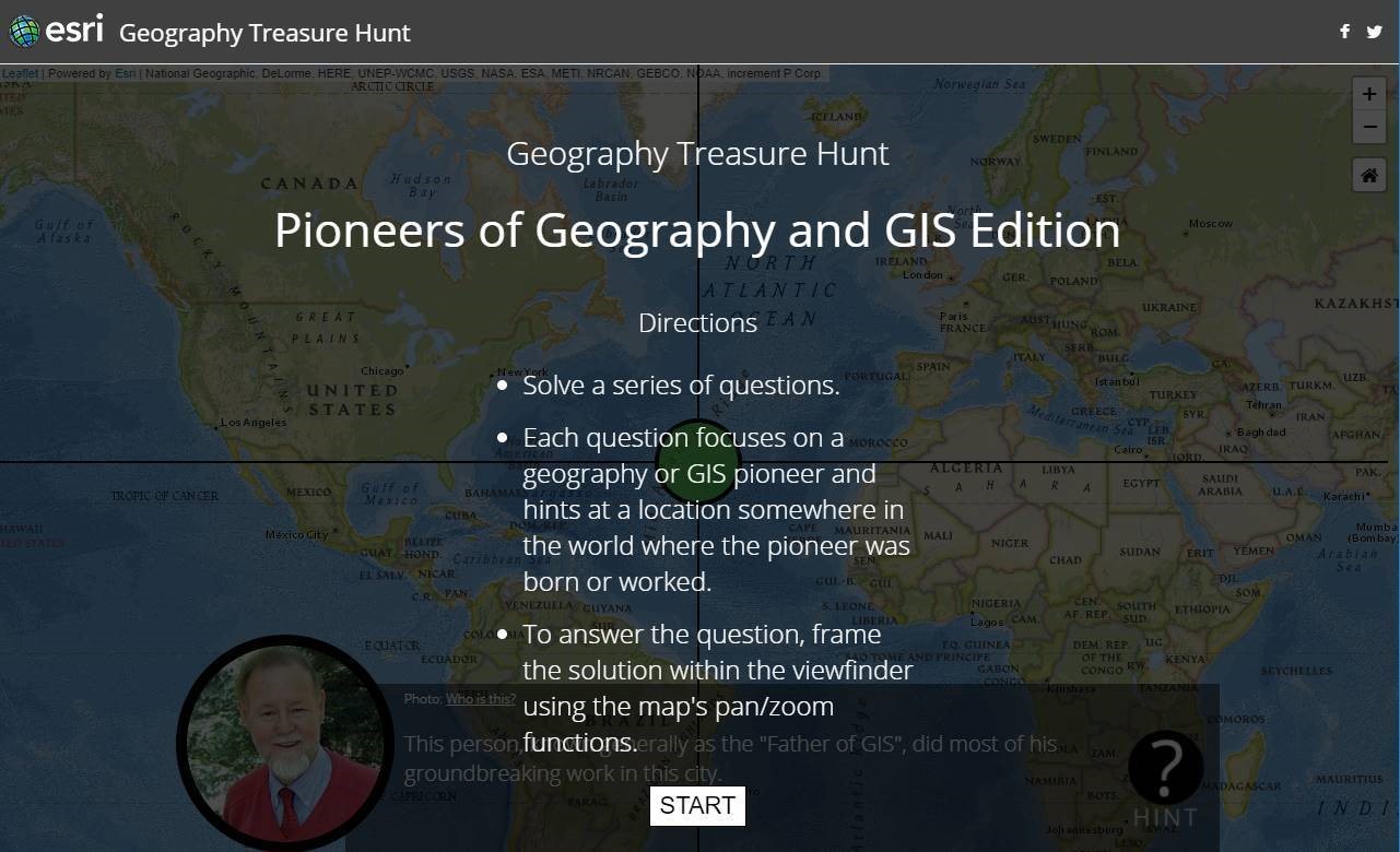
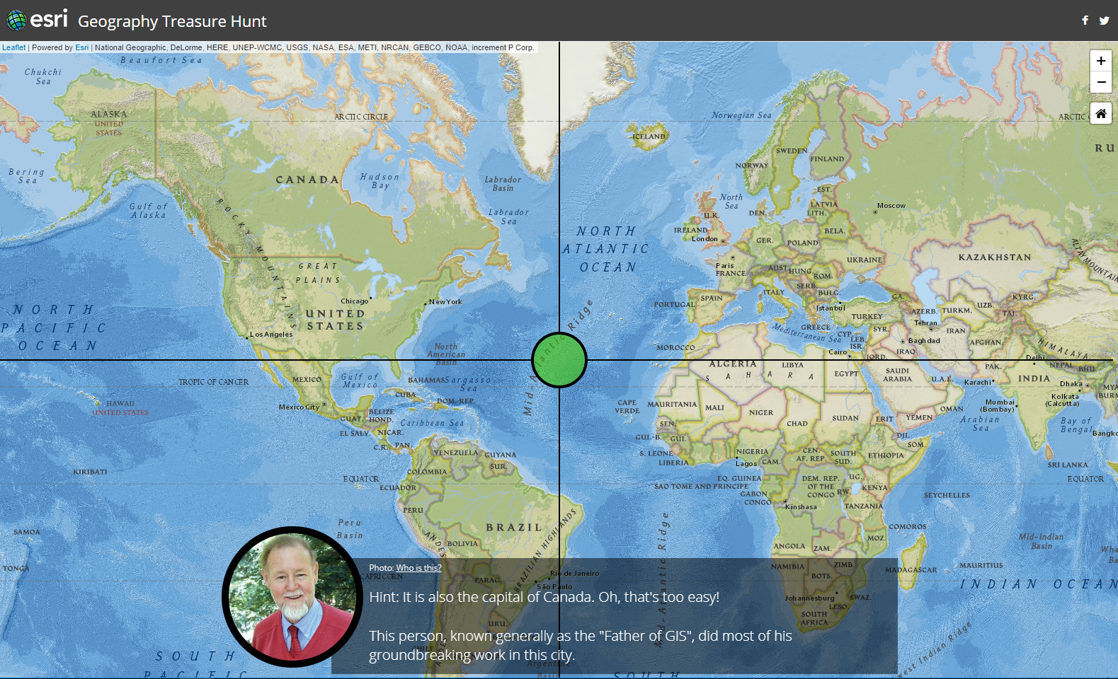
Sections of the geography and GIS pioneers treasure hunt quiz.
Which type of quizzes do you think GIS is most effective for? I look forward to your comments.
You must be a registered user to add a comment. If you've already registered, sign in. Otherwise, register and sign in.
-
Administration
38 -
Announcements
44 -
Career & Tech Ed
1 -
Curriculum-Learning Resources
177 -
Education Facilities
24 -
Events
46 -
GeoInquiries
1 -
Higher Education
518 -
Informal Education
264 -
Licensing Best Practices
46 -
National Geographic MapMaker
10 -
Pedagogy and Education Theory
187 -
Schools (K - 12)
282 -
Schools (K-12)
183 -
Spatial data
24 -
STEM
3 -
Students - Higher Education
231 -
Students - K-12 Schools
84 -
Success Stories
22 -
TeacherDesk
1 -
Tech Tips
83
- « Previous
- Next »