- Home
- :
- All Communities
- :
- Industries
- :
- Education
- :
- Education Blog
- :
- Fun with GIS 269: 2020 Competition Results
Fun with GIS 269: 2020 Competition Results
- Subscribe to RSS Feed
- Mark as New
- Mark as Read
- Bookmark
- Subscribe
- Printer Friendly Page
- Report Inappropriate Content
The 2020 ArcGIS Online Competition for US High Schools and Middle Schools was gearing up for the final quarter when March arrived. Just one of the 35 participating states had completed their work; the rest expected final pushes by students even into early May. Coronavirus brought serious roadblocks as students lost connectivity, devices, guidance, inspiration, and even the chance for fieldwork. Still, more than 500 in 29 states persevered, submitting storymaps about their research projects.
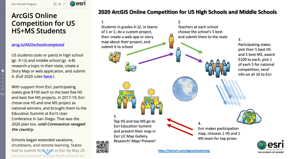
There were new guidelines in place for 2020, increasing attention to maps and analysis, limiting use of imagery and video. Coupled with the spring shakeup, most students had a harder time this year. The overall stats camouflage the difficulties, because the 527 entries is the most ever. But one single school provided over 40% of all the entries, meaning most of the other 76 schools with entries had some tough sledding.
We therefore decided not to focus attention on a tiny handful of prize winners, but rather to highlight what viewers, teachers, and students should look at in these projects, and especially to see how some students did a particularly good job with this element or that.
When I was teaching geography to 8th graders, over my chalkboard was a sign:
"Geography = 3 Questions: What's where? Why is it there? So what?"
This is the crux of the competition: to identify and research a chosen phenomenon in a specific region, discover and illuminate the patterns, and lay out the impact, using GIS. By far the hardest part of the competition is formulating and answering the three questions. This, and the technology involved in meeting the challenge, is what draws some people.
At Sauk Rapids-Rice High School in Minnesota, this is why they do the project as part of 9th grade Geography class. All 320 students spent three weeks in late winter diving deep into the process of geographic inquiry. Students from three of the four teachers had just finished projects when lockdowns struck, and some chose to keep tinkering. They came up with a question, wrestled with data to analyze it, and prepared storymaps, addressing a bunch of state educational standards [see 8.3] along the way. "This makes people think. It's high-level thinking, geographic content, soft skills, and some kids even already want to do it when they're older," said teachers Brianne Wegter, Melissa Gebhardt, and Andrew Weber. These teachers followed a great plan: rely on exposures to intro materials in middle school and early in 9th grade, then launch into the project for a good chunk of time, well into the year. Their results speak volumes.
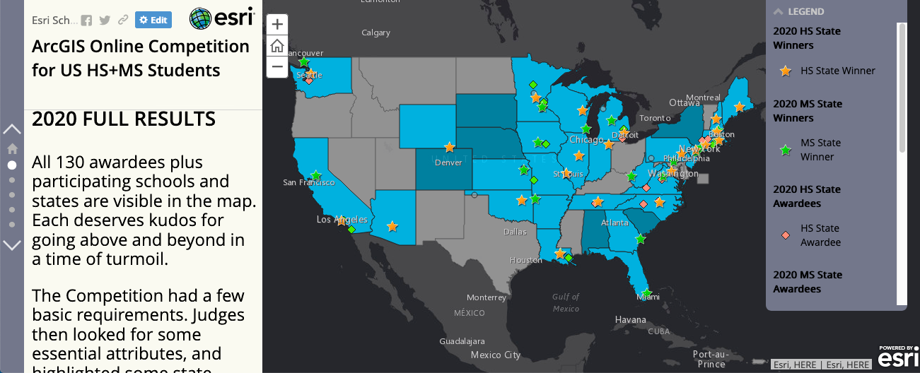
Explore all the results. See how some students met and even exceeded the expectations. Enjoy the way students see the world, and investigate and answer their own questions. And plan for the 2021 Competition.
You must be a registered user to add a comment. If you've already registered, sign in. Otherwise, register and sign in.
-
Administration
38 -
Announcements
44 -
Career & Tech Ed
1 -
Curriculum-Learning Resources
178 -
Education Facilities
24 -
Events
47 -
GeoInquiries
1 -
Higher Education
518 -
Informal Education
265 -
Licensing Best Practices
46 -
National Geographic MapMaker
10 -
Pedagogy and Education Theory
187 -
Schools (K - 12)
282 -
Schools (K-12)
184 -
Spatial data
24 -
STEM
3 -
Students - Higher Education
231 -
Students - K-12 Schools
85 -
Success Stories
22 -
TeacherDesk
1 -
Tech Tips
83
- « Previous
- Next »