- Home
- :
- All Communities
- :
- Industries
- :
- Education
- :
- Education Blog
- :
- Fun with GIS 266: Educating for Uncertainty
Fun with GIS 266: Educating for Uncertainty
- Subscribe to RSS Feed
- Mark as New
- Mark as Read
- Bookmark
- Subscribe
- Printer Friendly Page
- Report Inappropriate Content
Facing disaster, the best odds for effective response lie with the generalist. Adaptability is crucial. Prior knowledge is useful, but especially about problem solving. At least as important are willingness to attempt, to fail without discouragement, tenacity in action, and an insatiable appetite for learning. These traits combine flexibly and repurpose quickly and easily, giving the best chance for success under the widest array of unpredictable conditions.
We have been pitched thru a one-way door into a bad-dream house of glass and mirrors, with collective vision of an exit clear, but proper path unlabeled, and people pointing in many directions. Parents are thrust into teaching at home; teachers are forced to abandon historic patterns; youngsters are isolated; and those less fortunate grow even more so. No direction is ideal. Never before have so many understood intestinally the meaning of "unprecedented."
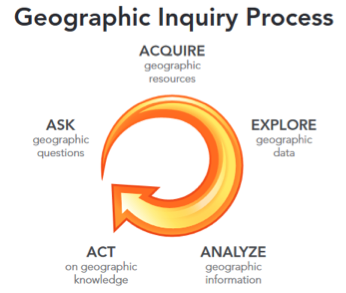
In these conditions, what is the role of education? As always, it is to provide both roots and wings: an understanding of what is in place and how it came to be, and the ability to reach out and venture beyond. Of course, the parameters vary by age, experience, and situation, but a third grader can appreciate danger without being immobilized just as a high school senior approaching graduation can grasp the vagaries of "the future." Each may be best served by focusing on what can help them adapt to uncertainty: ability to ask questions, gather information, explore situations from multiple perspectives, analyze data and integrate diverse elements, and act.
This is what GIS practitioners do. A quick look at Esri's Industries page proves that these tools and skills have universal relevance. Some skills are built in seconds just through exploration; the more elaborate take hours of thoughtful study and practice. But the more skills, tools, data sets, perspectives, examples, and experiences one assembles, the more capable one becomes. This is why I have witnessed employers fidget with excitement when seeing high schoolers' projects, and college recruiters' eyes light up when hearing middle schoolers share their experiences, and civic leaders' jaws drop upon grasping what elementary students have discovered.
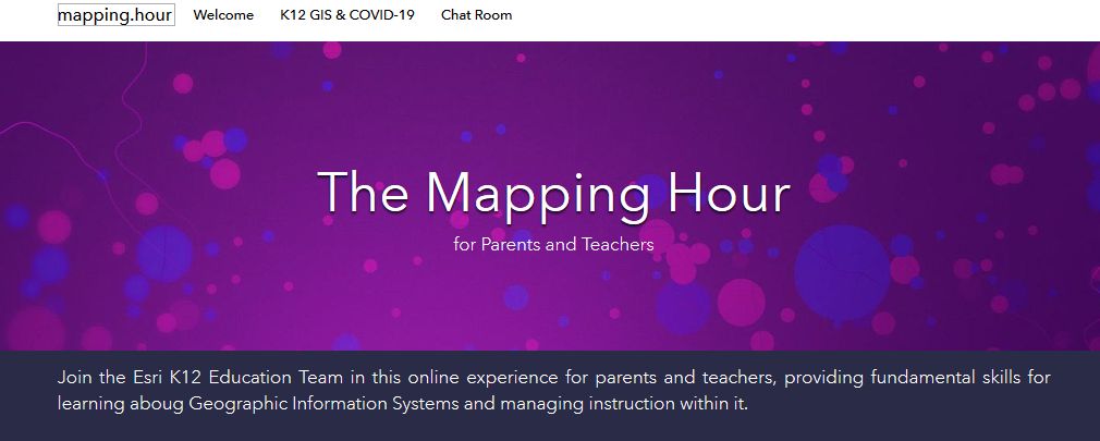
We cannot choose the winds and currents that greet us; we can only choose how we cope with them. To support learners most effectively, we need to help them construct a framework for understanding conditions, tools with which to explore and experiment, skills for thinking critically and solving problems, perspectives that honor diversity, and an insatiable thirst for learning. This is GIS -- a toolbelt, a mindset, a knowledge base, and a vision. It's never too soon -- or too late -- to begin learning. If you are a parent or teacher, feeling adrift, just discovering the indelible blazes of this trail, and pondering whether and where to begin, check out the Mapping Hour videos. Build a path for your learners.
You must be a registered user to add a comment. If you've already registered, sign in. Otherwise, register and sign in.
-
Administration
38 -
Announcements
44 -
Career & Tech Ed
1 -
Curriculum-Learning Resources
178 -
Education Facilities
24 -
Events
47 -
GeoInquiries
1 -
Higher Education
518 -
Informal Education
265 -
Licensing Best Practices
46 -
National Geographic MapMaker
10 -
Pedagogy and Education Theory
187 -
Schools (K - 12)
282 -
Schools (K-12)
184 -
Spatial data
24 -
STEM
3 -
Students - Higher Education
231 -
Students - K-12 Schools
85 -
Success Stories
22 -
TeacherDesk
1 -
Tech Tips
83
- « Previous
- Next »