- Home
- :
- All Communities
- :
- Industries
- :
- Education
- :
- Education Blog
- :
- Spatial Technology – An Online Course for Educator...
Spatial Technology – An Online Course for Educators and Students
- Subscribe to RSS Feed
- Mark as New
- Mark as Read
- Bookmark
- Subscribe
- Printer Friendly Page
- Report Inappropriate Content
Are you new to GIS, or spatial technology?Do you want to improve your spatial technology skills?A new online course created by an educator FOR educators - and students - is now available online (click here for more)!What is spatial technology?Spatial technology is about measuring and representing the world using innovative and high-tech tools. Using spatial technology such as GPS, GIS and Remote Sensing, spatial information can be collected and analysed from the ground, the air, and from space. This information can be used in hundreds of different applications ranging from natural hazard mitigation to modelling the effects of climate change. What does this course offer?This extensive course (Module 4: Spatial Technology) provides:
Who should enroll?The options provided in this course make it suitable for:
When is the course available?This course can be completed at any time over any time period. There are a number of required tasks for satisfactory completion. Who created the course?The course was created by Joseph Kerski, PhD GISP, a geographer with 30 years of experience in geography and GIS education, working in close collaboration with the Geography Teachers Association of Victoria. While some of the places studied focus on Australia, many other areas of the world are examined, and you can use all of the ideas presented in the course to study your OWN community, region, and country. Time and PriceEstimated 20–25 hours to complete the required tasks. Price: Australian $250. CertificateA certificate is provided on completion of the formal assessment for this course. This is module 4 in the Certificate of Geography Competency. You can take Spatial Technology as a stand-alone course OR you can take this course along with the 4 others in the Geography Competency certificate. But note that there is no requirement to complete the other modules. Course Structure1. An introduction to Geospatial technologies. 2. Using spatial technology in Geography. 3. Analysing change over space and time. 4. Exploring regions. 5. Mapping your own data. 6. Analysis and synthesis. 7. Formal assessment. One of the videos in the course video playlist, describing what Spatial Technologies are and why they are relevant and exciting for educational use. Why the GTAV?This course is offered through the Geography Teachers Association of Victoria, Australia (GTAV), one of the world's preeminent geography education professional societies. Esri, Esri Australia, and GTAV have been partnering to further geographic content and skills for educators for a number of years. By taking this course through GTAV, you have the advantage of networking with some truly inspiring educators, and you have the support of all of these organizations to provide you with advice and/or any technical support you might need along the way. For Further InformationSee the information on www.gtav-ecourses.asn.au, contact the author of this blog Joseph Kerski (jkerski@esri.com), peruse the set of videos here, comment below, or contact the GTAV office.
|
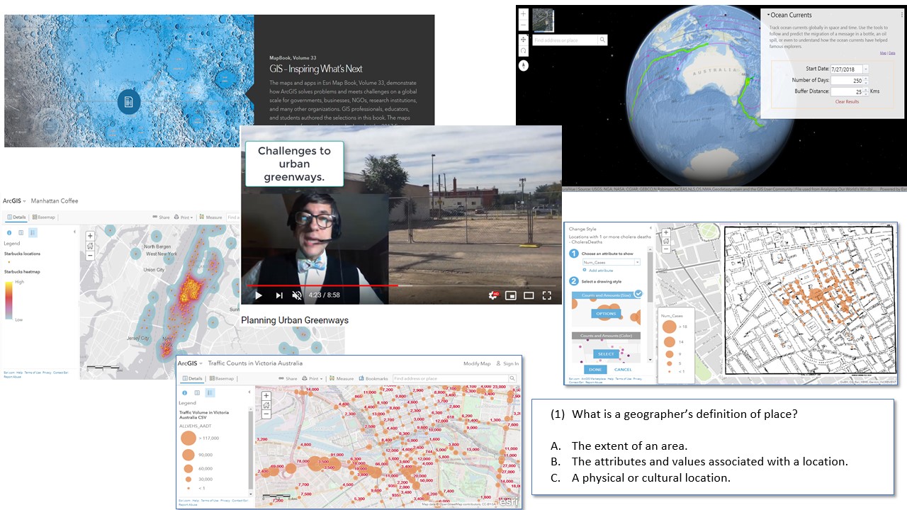 Selection of course quizzes, hands-on work, readings, and videos.
You must be a registered user to add a comment. If you've already registered, sign in. Otherwise, register and sign in.
-
Administration
38 -
Announcements
44 -
Career & Tech Ed
1 -
Curriculum-Learning Resources
178 -
Education Facilities
24 -
Events
47 -
GeoInquiries
1 -
Higher Education
518 -
Informal Education
265 -
Licensing Best Practices
46 -
National Geographic MapMaker
10 -
Pedagogy and Education Theory
187 -
Schools (K - 12)
282 -
Schools (K-12)
184 -
Spatial data
24 -
STEM
3 -
Students - Higher Education
231 -
Students - K-12 Schools
85 -
Success Stories
22 -
TeacherDesk
1 -
Tech Tips
83
- « Previous
- Next »