- Home
- :
- All Communities
- :
- Industries
- :
- Education
- :
- Education Blog
- :
- [Archive] The Evolution of Esri’s MOOC Program, Pa...
[Archive] The Evolution of Esri’s MOOC Program, Part III
- Subscribe to RSS Feed
- Mark as New
- Mark as Read
- Bookmark
- Subscribe
- Printer Friendly Page
- Report Inappropriate Content
[Originally published in Esri Insider, June 22, 2015]
By Jim Baumann
Looking into the Future
David DiBiase is Director of Esri’s Education Outreach team and former Director of the John A. Dutton e-Education Institute at Pennsylvania State University. I recently had the opportunity to chat with David about the importance of offering Massive Open Online Courses (MOOCs) as part of Esri’s well-established education program. In the third and final part of our discussion, David talks about the future of the MOOC program at Esri. [Read the first and second parts of our discussion.]
Baumann: What’s in the future for MOOCs at Esri?
DiBiase: Many students express excitement about the capabilities of ArcGIS Online, and appreciation to Esri for offering the course. Many are experienced ArcGIS users. Many others are new to Esri. The company is pleased with the response. We plan to offer Going Places with Spatial Analysis two or three times in 2015, depending on demand.
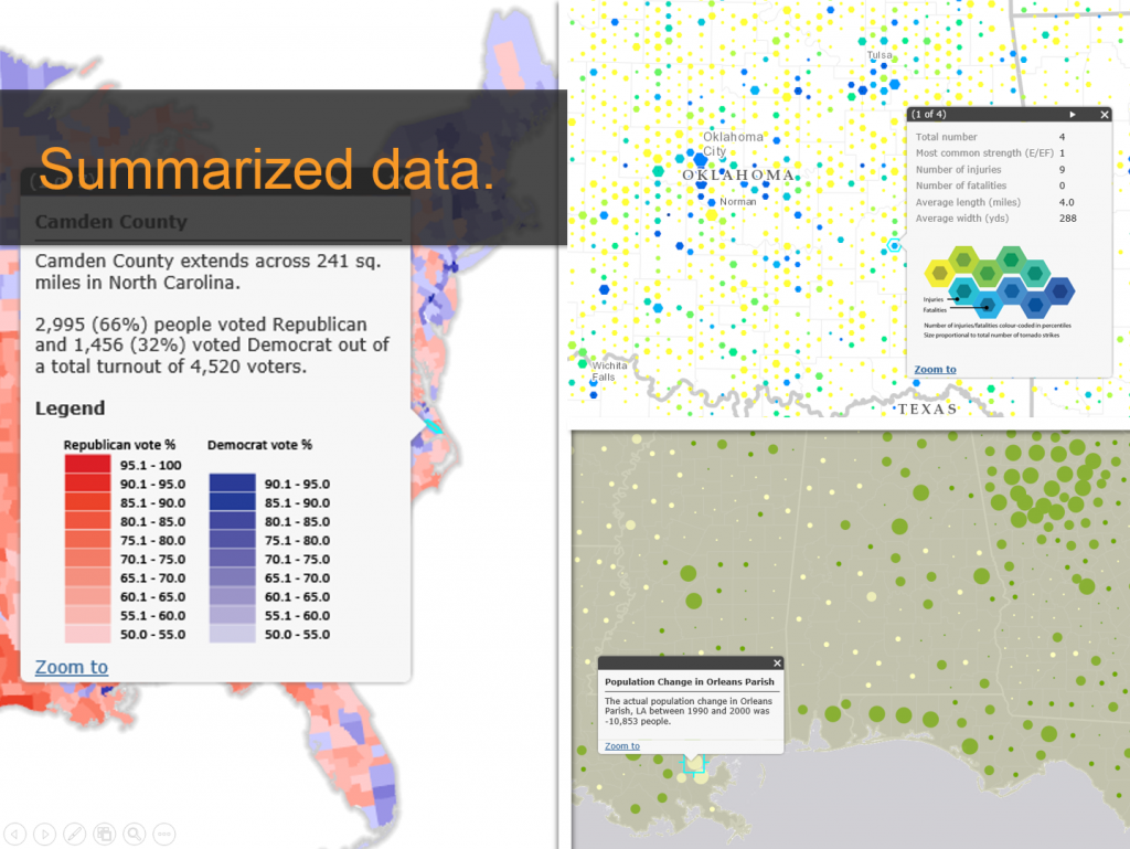
By summarizing data in different ways you can reveal patterns, answers questions and support further analysis.
We’ve also designed a second MOOC. Course design begins with a target audience, which in this case is current students and recent graduates of business schools, both bachelor’s and MBAs. We assembled a team of Esri people with recent business degrees to advise us, and we have a small group of GIS-savvy B-school faculty members who are eager to help. We want to help folks coming out of B-schools see how location analytics can give them a competitive edge in a tough job market. We’ve titled the MOOC The Location Advantage. We offered it for the first time in May and it is now in progress.
Based on the reception of Going Places with Spatial Analysis within and beyond the company, I expect Esri will develop a suite of MOOCs to help expose our technology and outlook beyond our existing user base. We’re already discussing the possibility of a third MOOC to be developed in late 2015, but we haven’t settled on an audience or topic yet. Meanwhile, we’re mindful that free, large-scale online courses are expensive to build, maintain, promote, and run. Whether Esri will be able to sustain this effort remains to be seen. But I like to think that if we continue to attract both the large numbers of enrollees and positive reviews, we’ll be able to grow our MOOC portfolio in years to come.
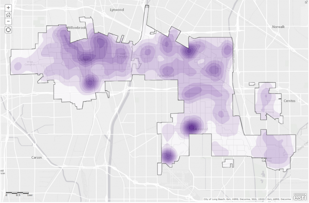
Creating density surfaces can simplify complex data and bring new insights to support decision making.
Baumann: What sort of educational opportunities are available from Esri for those students that have taken the MOOC and want to continue learning GIS?
DiBiase: We define success in part by the number of MOOC students who seek to learn more about GIS and Esri. At the conclusion of each MOOC offering we suggest a number of next steps. Students can seek out further training opportunities provided by Esri’s Training Services group (training.esri.com), including self-paced web courses and seminars. They may also move on to Learn GIS (learn.arcgis.com), Esri’s newest education destination, where they can join an ArcGIS Online organization for free and access additional case-based self-study exercises. We also encourage students to check out Esri’s ArcGIS for Home Use license, which enables anyone to run ArcGIS for Desktop on their personal computer for noncommercial use. The Home Use license also includes an ArcGIS Online subscription account. Finally, we’re happy to discuss formal education opportunities at leading institutions, both online and on campus.
Baumann: How important do you believe MOOCS are in educating people about the power of GIS?
DiBiase: Back in 2003, the US Department of Labor identified “geospatial technology” as a high growth tech industry, along with biotech and nanotech. At the same time, however, they pointed out that awareness of the industry remained low. We’re still struggling to achieve mainstream awareness of our technology and our field. MOOCs may be helping.
Esri has a loyal and energetic following among its customers and friends. You can think of that as a kind of constellation of individuals and organizations that orbit Esri. However, business-to-business companies like Esri struggle mightily to reach people beyond their orbit.
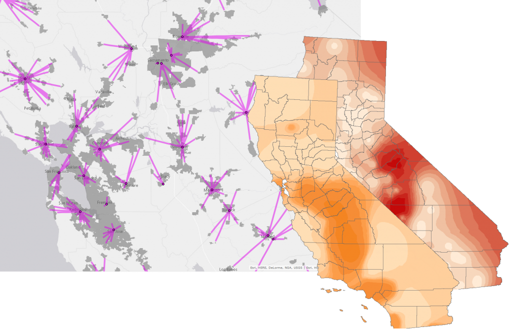
Students explore population exposures: locating the nearest monitoring stations or, finding the predicted exposure.
Our goal is to reach people who may not know what GIS is or haven’t heard of Esri. In the context of higher education, we want to reach beyond the traditional map-conscious disciplines like geography to others such as health, business, engineering, computer science, and even the humanities. Attracting the interest and participation of these disciplines has always been a challenge for my team. I personally am not aware of any strategy for broadening our reach beyond our own constellation than MOOCs, because MOOCs are an opportunity for people to exercise their curiosity and expand their horizons. MOOCS are a low-cost, low-risk means to explore things about the world that you might not encounter otherwise.
I think there are a lot more people who would be interested in GIS if we expose it in a way that is not only challenging, but also supportive and fun, and that’s what we try to do with these MOOCs. I believe this is one of the best strategies we have for helping the wider world understand the power of the geographic perspective and the effectiveness of geospatial technologies to bring geography to life. Time will tell if that hunch is right, but from this early vantage point I’m optimistic.
About Jim Baumann
Jim Baumann is a longtime employee at Esri. He has written articles on GIS technology and the computer graphics industry for more than 30 years.
You must be a registered user to add a comment. If you've already registered, sign in. Otherwise, register and sign in.
-
Administration
38 -
Announcements
45 -
Career & Tech Ed
1 -
Curriculum-Learning Resources
179 -
Education Facilities
24 -
Events
47 -
GeoInquiries
1 -
Higher Education
519 -
Informal Education
266 -
Licensing Best Practices
46 -
National Geographic MapMaker
11 -
Pedagogy and Education Theory
187 -
Schools (K - 12)
282 -
Schools (K-12)
185 -
Spatial data
24 -
STEM
3 -
Students - Higher Education
231 -
Students - K-12 Schools
86 -
Success Stories
22 -
TeacherDesk
1 -
Tech Tips
83
- « Previous
- Next »