Turn on suggestions
Auto-suggest helps you quickly narrow down your search results by suggesting possible matches as you type.
Cancel
- Home
- :
- All Communities
- :
- Industries
- :
- Education
- :
- Education Blog
- :
- The World’s Most Remote Island Group: Hawaii?
The World’s Most Remote Island Group: Hawaii?
Subscribe
4554
0
06-29-2017 12:18 AM
- Subscribe to RSS Feed
- Mark as New
- Mark as Read
- Bookmark
- Subscribe
- Printer Friendly Page
- Report Inappropriate Content
06-29-2017
12:18 AM
In a separate blog post at the ESRI Education Community, I investigated a claim that Bouvet Island is the world’s most remote uninhabited island using ArcGIS. At the same time, I mentioned that the definition of “remoteness” is subjective and therefore makes for an excellent classroom discussion and for investigation using GIS.
If you’ve flown to Hawaii, you may have been amazed at long the flight is, and wondered whether Hawaii is halfway across the Pacific Ocean. The Hawaiian Islands is the world’s most remote island chain with a sizeable population, estimated at 1.288 million in 2008 (US Census Bureau). Honolulu is the most remote major city over 500,000 population, because the nearest city of equal or greater size is San Francisco, 3,841 km distant.
Using ArcGIS and data from Book 2 of the Our World GIS Education series from ESRI Press, I set the data frame to Orthographic, centered near Maui at 21 North Latitude and 156 West Longitude so that I could see most of the Pacific Ocean on the map image.
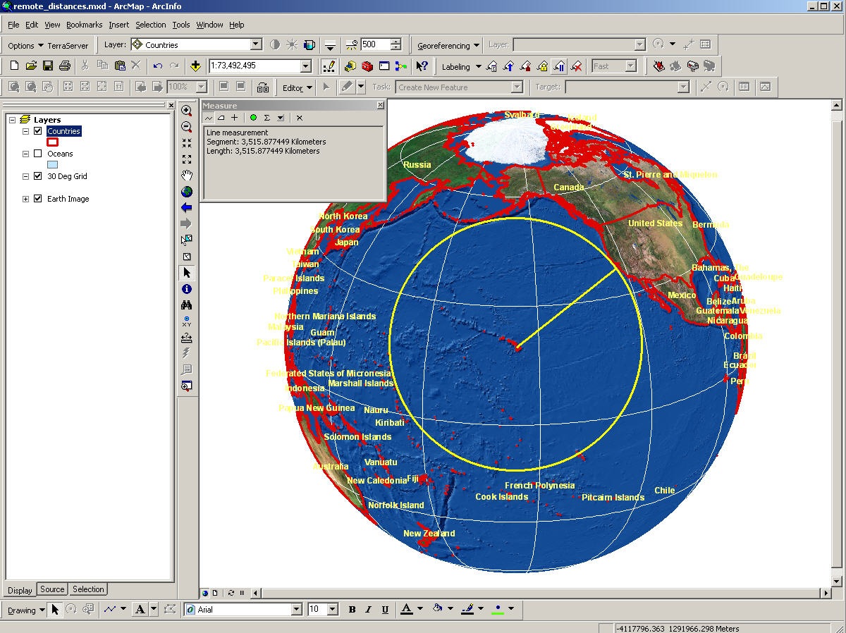
Which is closer to Hawaii—California or southwest Alaska? Using the circle tool, above, I found out that these two are just about the same distance away—3,515 km. This is approximate as the measure tool was used at a small scale.
Is Hawaii halfway across the ocean? A visual assessment shows that this depends on the point at which one measures, for the Hawaiian Islands extend for hundreds of kilometers—over 1,000 including the seamounts. The southeastern inhabited Hawaiian islands are not quite halfway across the ocean: I measured with ArcGIS about 4,800 km from Hawaii to the nearest point on the Asian continent at Kamchatka, and 5,800 to Australia. Vladivostok (5,500 km) and Shanghai (6,400 km) are both farther than Kamchatka, and all are farther than North America.
A discussion about map projections, distances, and error is most appropriate here, because the measurements differ by up to 1,000 km depending on the map projection used. Try these tools to investigate other islands!
- Joseph Kerski, Education Manager, ESRI.
You must be a registered user to add a comment. If you've already registered, sign in. Otherwise, register and sign in.
About the Author
I believe that spatial thinking can transform education and society through the application of Geographic Information Systems for instruction, research, administration, and policy.
I hold 3 degrees in Geography, have served at NOAA, the US Census Bureau, and USGS as a cartographer and geographer, and teach a variety of F2F (Face to Face) (including T3G) and online courses. I have authored a variety of books and textbooks about the environment, STEM, GIS, and education. These include "Interpreting Our World", "Essentials of the Environment", "Tribal GIS", "The GIS Guide to Public Domain Data", "International Perspectives on Teaching and Learning with GIS In Secondary Education", "Spatial Mathematics" and others. I write for 2 blogs, 2 monthly podcasts, and a variety of journals, and have created over 5,000 videos on the Our Earth YouTube channel.
Yet, as time passes, the more I realize my own limitations and that this is a lifelong learning endeavor and thus I actively seek mentors and collaborators.
Labels
-
Administration
38 -
Announcements
45 -
Career & Tech Ed
1 -
Curriculum-Learning Resources
179 -
Education Facilities
24 -
Events
47 -
GeoInquiries
1 -
Higher Education
519 -
Informal Education
266 -
Licensing Best Practices
46 -
National Geographic MapMaker
11 -
Pedagogy and Education Theory
187 -
Schools (K - 12)
282 -
Schools (K-12)
185 -
Spatial data
24 -
STEM
3 -
Students - Higher Education
231 -
Students - K-12 Schools
86 -
Success Stories
22 -
TeacherDesk
1 -
Tech Tips
83
- « Previous
- Next »