Turn on suggestions
Auto-suggest helps you quickly narrow down your search results by suggesting possible matches as you type.
Cancel
- Home
- :
- All Communities
- :
- Industries
- :
- Education
- :
- Education Blog
- :
- How Can GIS Help With AP Human Geography? Part 1 o...
How Can GIS Help With AP Human Geography? Part 1 of 2
Subscribe
1035
0
06-29-2017 12:35 AM
- Subscribe to RSS Feed
- Mark as New
- Mark as Read
- Bookmark
- Subscribe
- Printer Friendly Page
- Report Inappropriate Content
06-29-2017
12:35 AM
For five decades, the College Board’s Advanced Placement Program (AP) has provided students with the opportunity to take college-level coursework and earn college credit while still in high school. AP courses exist in 30 different subjects, each ending with a rigorous exam. The tireless efforts of many geography educators culminated in the first AP Human Geography (APHG) course, offered in 2001 with 3,272 students taking the exam. In 2010, over 61,000 students took the APHG exam. During the summer of 2010, 39 APHG teacher institutes were held in 24 states. These are encouraging signs that the subject is gaining ground in the secondary school curriculum.
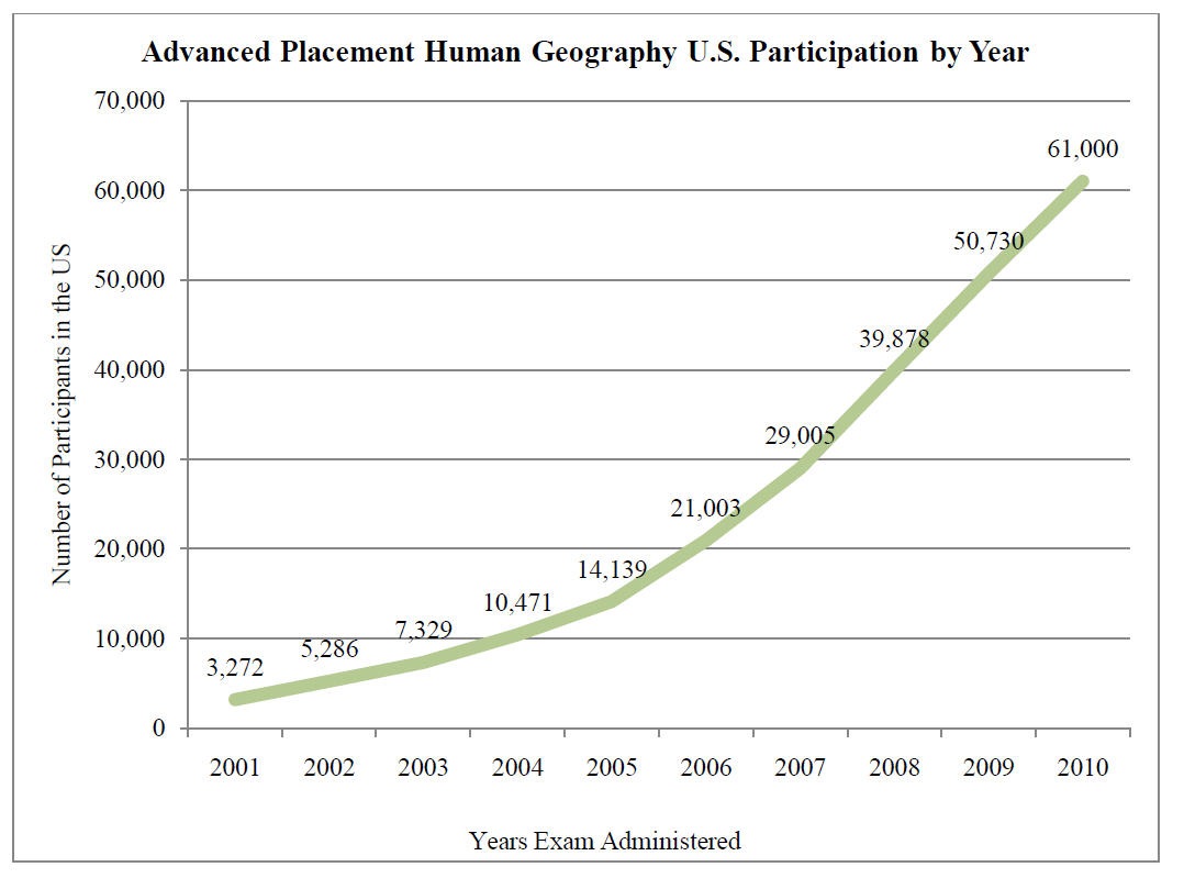
AP Human Geography participation by year. Samantha Ross, National Geographic.
The five major topics covered in APHG courses are based on the National Geography Standards developed in 1994. Upon the successful completion of the course, the student should be able to: (1) Use and think about maps and spatial data. (2) Understand and interpret the implications of associations among phenomena in places. (3) Recognize and interpret at different scales the relationships among patterns and processes. (4) Define regions and evaluate the regionalization process. (5) Characterize and analyze changing interconnections among places. I have personally observed teachers instructing APHG, and have always been impressed with the depth of the topics covered. It truly is the type of college-level course that I believe we need to be teaching more of in secondary education. I only wish we had an AP Physical Geography course as well! Would anyone like to spearhead that effort?
Unfortunately, the mean score for the APHG exam this year was 2.56, the lowest mean score for any AP test (passing is 3). Part of the reason is that most students taking the course are in Grade 9, with perhaps only one semester or one year of geography behind them, several years earlier. The use of GIS can help raise these scores and more importantly, help students understand the spatial patterns that are such an integral part of the course. How? We will explore that in my next blog column.
-Joseph Kerski, Esri Education Manager
You must be a registered user to add a comment. If you've already registered, sign in. Otherwise, register and sign in.
About the Author
I believe that spatial thinking can transform education and society through the application of Geographic Information Systems for instruction, research, administration, and policy.
I hold 3 degrees in Geography, have served at NOAA, the US Census Bureau, and USGS as a cartographer and geographer, and teach a variety of F2F (Face to Face) (including T3G) and online courses. I have authored a variety of books and textbooks about the environment, STEM, GIS, and education. These include "Interpreting Our World", "Essentials of the Environment", "Tribal GIS", "The GIS Guide to Public Domain Data", "International Perspectives on Teaching and Learning with GIS In Secondary Education", "Spatial Mathematics" and others. I write for 2 blogs, 2 monthly podcasts, and a variety of journals, and have created over 5,000 videos on the Our Earth YouTube channel.
Yet, as time passes, the more I realize my own limitations and that this is a lifelong learning endeavor and thus I actively seek mentors and collaborators.
Related Articles
How Can GIS Help With AP Human Geography? Part 2 of 2
JosephKerski
Esri Notable Contributor
0 Kudos
0 Comments
Labels
-
Administration
38 -
Announcements
45 -
Career & Tech Ed
1 -
Curriculum-Learning Resources
179 -
Education Facilities
24 -
Events
47 -
GeoInquiries
1 -
Higher Education
519 -
Informal Education
266 -
Licensing Best Practices
46 -
National Geographic MapMaker
11 -
Pedagogy and Education Theory
187 -
Schools (K - 12)
282 -
Schools (K-12)
185 -
Spatial data
24 -
STEM
3 -
Students - Higher Education
231 -
Students - K-12 Schools
86 -
Success Stories
22 -
TeacherDesk
1 -
Tech Tips
83
- « Previous
- Next »