Turn on suggestions
Auto-suggest helps you quickly narrow down your search results by suggesting possible matches as you type.
Cancel
- Home
- :
- All Communities
- :
- Industries
- :
- Education
- :
- Education Blog
- :
- How to Georeference a map and serve it in ArcGIS O...
How to Georeference a map and serve it in ArcGIS Online
Subscribe
5379
2
09-15-2016 10:59 PM
- Subscribe to RSS Feed
- Mark as New
- Mark as Read
- Bookmark
- Subscribe
- Printer Friendly Page
- Report Inappropriate Content
09-15-2016
10:59 PM
In response to inquiries that educators and others have had recently, I created several videos explaining how to georeference a map and serve it in ArcGIS Online, beginning here and continuing here and here. Georeferencing is the process of aligning spatial data in map form has no spatial information explicitly attached to it, usually because it has been scanned from film, paper, or another medium, and attaching spatial information to it. By "spatial information" we mean a real-world map projection and coordinate system. The process of georeferencing is powerful because it allows you to add historical or other documents to your GIS project, so that you can work with them just like you can with your other GIS maps and data. You match your scanned aerial photo, map, or other document by creating a series of control points, which I explain here. I did this using ArcGIS Desktop (ArcMap); soon you will be able to do this in ArcGIS Pro, and, I hope, someday in ArcGIS Online.
Georeferencing has been around for as long as GIS has existed--since the 1960s. But more recently, with the advent of cloud based GIS platforms such as ArcGIS Online, you can now serve your newly georeferenced data to the cloud, as I demonstrate in the third video in the series. Serving it in ArcGIS Online enables you to use it anywhere, on any device, at any time. Then, if you share your data in ArcGIS Online, others can use it as well in their own maps and projects.
Let's say you have georeferenced and uploaded a historical map, as I do in these videos with one of the wonderful historical Sanborn fire insurance maps, and now have published it to ArcGIS Online. Now you want to create a Swipe story map web mapping application so that you can compare how a city changed over time. I explain how to to do that in this video. As with any GIS-based project, being organized about your work is crucial, and in this video I demonstrate how to effectively use folders in ArcGIS Online to support your organized work.
I hope these resources will be valuable to the community and I look forward to hearing your comments and how you have used georeferencing in your own work.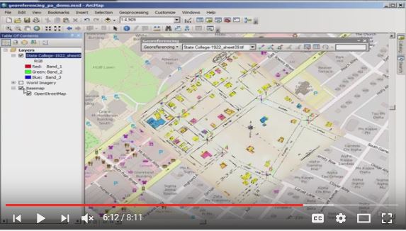
Georeferencing a historical map in ArcGIS.
2 Comments
You must be a registered user to add a comment. If you've already registered, sign in. Otherwise, register and sign in.
About the Author
I believe that spatial thinking can transform education and society through the application of Geographic Information Systems for instruction, research, administration, and policy.
I hold 3 degrees in Geography, have served at NOAA, the US Census Bureau, and USGS as a cartographer and geographer, and teach a variety of F2F (Face to Face) (including T3G) and online courses. I have authored a variety of books and textbooks about the environment, STEM, GIS, and education. These include "Interpreting Our World", "Essentials of the Environment", "Tribal GIS", "The GIS Guide to Public Domain Data", "International Perspectives on Teaching and Learning with GIS In Secondary Education", "Spatial Mathematics" and others. I write for 2 blogs, 2 monthly podcasts, and a variety of journals, and have created over 5,000 videos on the Our Earth YouTube channel.
Yet, as time passes, the more I realize my own limitations and that this is a lifelong learning endeavor and thus I actively seek mentors and collaborators.
Labels
-
Administration
38 -
Announcements
45 -
Career & Tech Ed
1 -
Curriculum-Learning Resources
179 -
Education Facilities
24 -
Events
47 -
GeoInquiries
1 -
Higher Education
519 -
Informal Education
266 -
Licensing Best Practices
46 -
National Geographic MapMaker
17 -
Pedagogy and Education Theory
187 -
Schools (K - 12)
282 -
Schools (K-12)
185 -
Spatial data
24 -
STEM
3 -
Students - Higher Education
231 -
Students - K-12 Schools
86 -
Success Stories
22 -
TeacherDesk
1 -
Tech Tips
83
- « Previous
- Next »