Turn on suggestions
Auto-suggest helps you quickly narrow down your search results by suggesting possible matches as you type.
Cancel
- Home
- :
- All Communities
- :
- Industries
- :
- Education
- :
- Education Blog
- :
- Mapillary: Capturing, Sharing, and Exploring Stree...
Mapillary: Capturing, Sharing, and Exploring Street Level Photos
Subscribe
746
0
01-14-2016 09:59 PM
- Subscribe to RSS Feed
- Mark as New
- Mark as Read
- Bookmark
- Subscribe
- Printer Friendly Page
- Report Inappropriate Content
01-14-2016
09:59 PM
Mapillary is a tool that allows anyone to create their own street level photographs, map them, and share them via web GIS technology. The idea behind Mapillary is a simple but powerful one: Take photos of a place of interest as you walk along using the Mapillary mobile app. Next, upload the photos to Mapillary again using the app. They will be connected with others’ and combined into a street level photo view. Then, explore your places and those from thousands of other users around the world.
Mapillary is part of the rapidly growing crowdsourcing movement, also known as citizen science, which seeks to generate "volunteered geographic information" content from ordinary citizens. Mapillary is therefore more than a set of tools--it is a community, with its own MeetUps and ambassadors. Mapillary is also a new Esri partner, and through an ArcGIS integration, local governments and other organizations can understand their communities in real-time, and "the projects they’re working on that either require a quick turnaround or frequent updates, can be more streamlined." These include managing inventory and city assets, monitoring repairs, inspecting pavement or sign quality, and assessing sites for new train tracks. Other organizations are also using Mapillary: For example, the Missing Maps Project is a collaboration between the American Red Cross, British Red Cross, Médecins Sans Frontières-UK (MSF-UK, or Doctors Without Borders-UK), and the Humanitarian OpenStreetMap Team. The project aims to map the most vulnerable places in the developing world so that NGOs and individuals can use ...
On the discovery section of Mapillary, you can take a tour through the ancient city Teotihuacán in Mexico, Astypalaia, one of the Dodecanese Islands in Greece, Pompeii, or Antarctica. But if you create an account and join the Mapillary community, you can access the live web map and click on any of the mapped tracks.
Mapillary can serve as an excellent way to help your students get outside, think spatially, use mobile apps, and use geotechnologies. Why stop at streets? You or your students could map trails, as I have done while hiking or biking, or map rivers and lakes from a kayak or canoe. There is much to be mapped, explored, studied, and enjoyed. If you'd like extra help in mapping your campus, town, or field trip with Mapillary, send an email to Mapillary and let the team know what you have in mind. They can help you and your students get started with ideas and tips (and bike mounts, if you need them).
For about 18 months, I have been using Mapillary to map trails and streets. I used the Mapillary app on my smartphone, generating photographs and locations as I hiked along. One of the trails that I mapped is shown below and also on the global map that everyone in the Mapillary community can access. I have spoken with the Mapillary staff and salute their efforts.
I look forward to hearing your reactions and how you use this tool.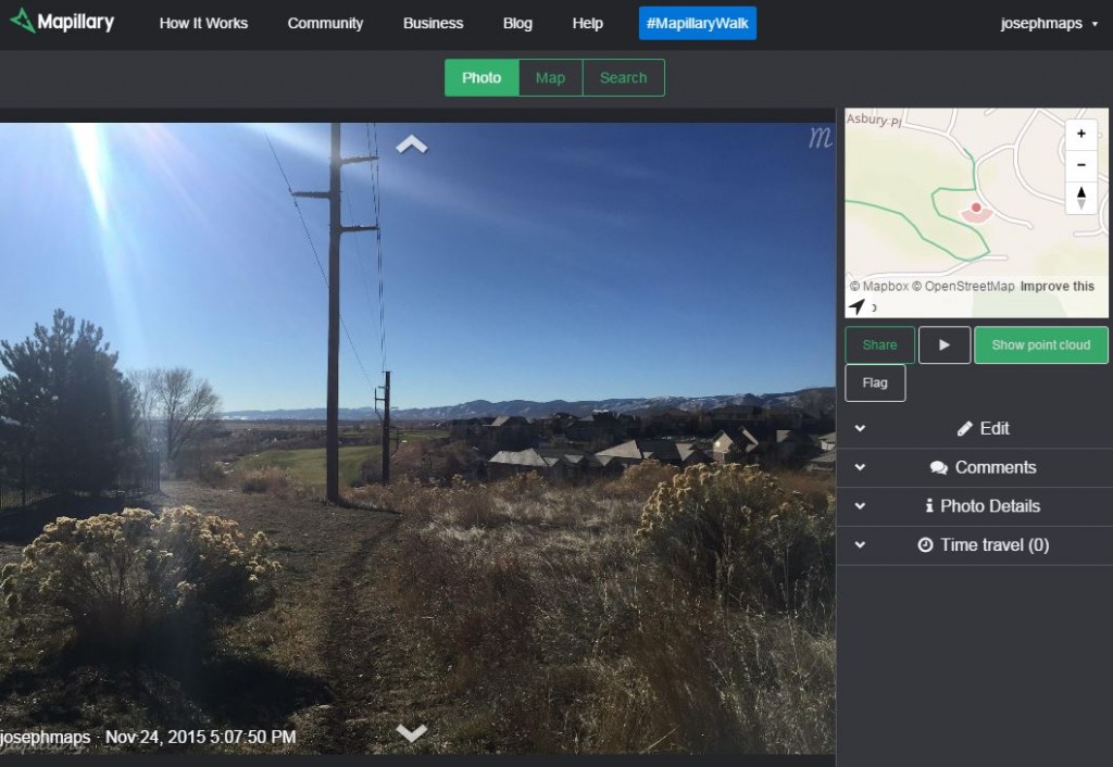
Mapillary tool for generating and sharing street level photos and maps.
You must be a registered user to add a comment. If you've already registered, sign in. Otherwise, register and sign in.
About the Author
I believe that spatial thinking can transform education and society through the application of Geographic Information Systems for instruction, research, administration, and policy.
I hold 3 degrees in Geography, have served at NOAA, the US Census Bureau, and USGS as a cartographer and geographer, and teach a variety of F2F (Face to Face) (including T3G) and online courses. I have authored a variety of books and textbooks about the environment, STEM, GIS, and education. These include "Interpreting Our World", "Essentials of the Environment", "Tribal GIS", "The GIS Guide to Public Domain Data", "International Perspectives on Teaching and Learning with GIS In Secondary Education", "Spatial Mathematics" and others. I write for 2 blogs, 2 monthly podcasts, and a variety of journals, and have created over 5,000 videos on the Our Earth YouTube channel.
Yet, as time passes, the more I realize my own limitations and that this is a lifelong learning endeavor and thus I actively seek mentors and collaborators.
Labels
-
Administration
38 -
Announcements
45 -
Career & Tech Ed
1 -
Curriculum-Learning Resources
179 -
Education Facilities
24 -
Events
47 -
GeoInquiries
1 -
Higher Education
519 -
Informal Education
266 -
Licensing Best Practices
46 -
National Geographic MapMaker
11 -
Pedagogy and Education Theory
187 -
Schools (K - 12)
282 -
Schools (K-12)
185 -
Spatial data
24 -
STEM
3 -
Students - Higher Education
231 -
Students - K-12 Schools
86 -
Success Stories
22 -
TeacherDesk
1 -
Tech Tips
83
- « Previous
- Next »