Turn on suggestions
Auto-suggest helps you quickly narrow down your search results by suggesting possible matches as you type.
Cancel
- Home
- :
- All Communities
- :
- Industries
- :
- Education
- :
- Education Blog
- :
- Use Field Notes App to Explore the World on your S...
Use Field Notes App to Explore the World on your Smartphone
Subscribe
764
0
08-14-2015 12:00 AM
- Subscribe to RSS Feed
- Mark as New
- Mark as Read
- Bookmark
- Subscribe
- Printer Friendly Page
- Report Inappropriate Content
08-14-2015
12:00 AM
What's it like on Planet Earth at the spot where you are located right now? Use the new Field Notes - Earth to find out. The app, available on iOS and Android, uses the power of three new global maps to help answer important questions about the current and future conditions on Planet Earth.
The three maps in the app include people (world population), life (ecological land units), and oceans (world seafloor geomorphology). The app is an example of some of the rich content available from the Esri Living Atlas of the World and was built using Esri's AppStudio for ArcGIS.
To use the app, either choose your current location, or any place on the planet that you are interested in, and start learning. I used the app last week in Washington DC while I was there for the National Conference on Geography Education, which I thought was the perfect venue for using it. In that location, the climate is predicted to be much warmer by 2050; it is 1,038 miles to the nearest volcano, but it is only 74 miles to a location that experienced a recent earthquake. I can find out about the terrain, the nearest available farmland and fresh water, and much more. The best part: I can also add a second location to compare and contrast the two locations side-by-side.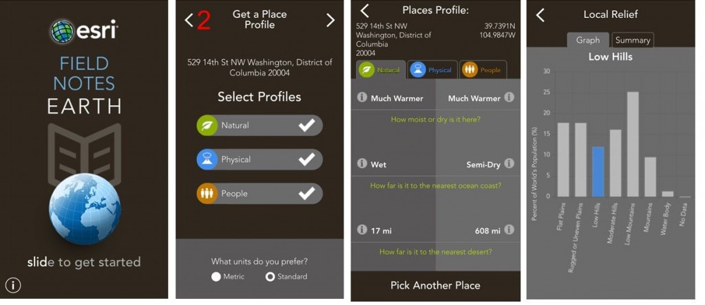
For another reflection on this app, see the article from Time magazine.
In instruction, you could use this app to spark meaningful conversations about physical geography, cultural geography, environmental science, and much more, with themes including change over time and space, human-environment interactions, and others. Use it but also get outside and observe using your five senses. I daresay that this is the type of tool that you could also use in your "elevator pitch" when you are asked in your everyday experience, "What is GIS?" or "Why does geography matter"?
I look forward to your reactions and comments.
The three maps in the app include people (world population), life (ecological land units), and oceans (world seafloor geomorphology). The app is an example of some of the rich content available from the Esri Living Atlas of the World and was built using Esri's AppStudio for ArcGIS.
To use the app, either choose your current location, or any place on the planet that you are interested in, and start learning. I used the app last week in Washington DC while I was there for the National Conference on Geography Education, which I thought was the perfect venue for using it. In that location, the climate is predicted to be much warmer by 2050; it is 1,038 miles to the nearest volcano, but it is only 74 miles to a location that experienced a recent earthquake. I can find out about the terrain, the nearest available farmland and fresh water, and much more. The best part: I can also add a second location to compare and contrast the two locations side-by-side.

Using the Field Notes Earth app--some screens and information that you will discover.
For another reflection on this app, see the article from Time magazine.
In instruction, you could use this app to spark meaningful conversations about physical geography, cultural geography, environmental science, and much more, with themes including change over time and space, human-environment interactions, and others. Use it but also get outside and observe using your five senses. I daresay that this is the type of tool that you could also use in your "elevator pitch" when you are asked in your everyday experience, "What is GIS?" or "Why does geography matter"?
I look forward to your reactions and comments.
You must be a registered user to add a comment. If you've already registered, sign in. Otherwise, register and sign in.
About the Author
I believe that spatial thinking can transform education and society through the application of Geographic Information Systems for instruction, research, administration, and policy.
I hold 3 degrees in Geography, have served at NOAA, the US Census Bureau, and USGS as a cartographer and geographer, and teach a variety of F2F (Face to Face) (including T3G) and online courses. I have authored a variety of books and textbooks about the environment, STEM, GIS, and education. These include "Interpreting Our World", "Essentials of the Environment", "Tribal GIS", "The GIS Guide to Public Domain Data", "International Perspectives on Teaching and Learning with GIS In Secondary Education", "Spatial Mathematics" and others. I write for 2 blogs, 2 monthly podcasts, and a variety of journals, and have created over 5,000 videos on the Our Earth YouTube channel.
Yet, as time passes, the more I realize my own limitations and that this is a lifelong learning endeavor and thus I actively seek mentors and collaborators.
Labels
-
Administration
38 -
Announcements
45 -
Career & Tech Ed
1 -
Curriculum-Learning Resources
179 -
Education Facilities
24 -
Events
47 -
GeoInquiries
1 -
Higher Education
519 -
Informal Education
266 -
Licensing Best Practices
46 -
National Geographic MapMaker
17 -
Pedagogy and Education Theory
187 -
Schools (K - 12)
282 -
Schools (K-12)
185 -
Spatial data
24 -
STEM
3 -
Students - Higher Education
231 -
Students - K-12 Schools
86 -
Success Stories
22 -
TeacherDesk
1 -
Tech Tips
83
- « Previous
- Next »