Turn on suggestions
Auto-suggest helps you quickly narrow down your search results by suggesting possible matches as you type.
Cancel
- Home
- :
- All Communities
- :
- Industries
- :
- Education
- :
- Education Blog
- :
- Mapping Cropland in ArcGIS Online
Mapping Cropland in ArcGIS Online
Subscribe
1100
0
04-17-2015 12:00 AM
- Subscribe to RSS Feed
- Mark as New
- Mark as Read
- Bookmark
- Subscribe
- Printer Friendly Page
- Report Inappropriate Content
04-17-2015
12:00 AM
I recently mentioned that maps, tools, and applications in ArcGIS Online continue to expand, highlighting the new map showing the distribution of Starbucks as an example. Another example touches on a subject that many students know very little about--agriculture. We have written about this topic in the past, offering curricular resources such as this one that asks students to analyze the distribution of four crops in the USA and this one asking students to investigate the distribution of five crops around the world using ArcGIS. A starting point for such investigations is simple but powerful maps of agricultural data, such as this one showing the acres of total cropland by county in the USA as a percentage of total land in a.... The data comes from the 2007 Census of Agriculture.
Does the pattern of agricultural land as a percentage of total land surprise you? Do the statistics that are visible when you select a county, indicating how much of the cropland is harvested, surprise you? What are some of the reasons for the spatial patterns that you see? If you live in the USA, how does your own county compare to the others in your region and across the country? What are some factors that explain how much land in a county is dedicated to agriculture? How would you rank the following factors: Soil health and type, climate, growing seasons, frequency of hailstorms and floods, landforms, relief, urban areas, and the height of the water table? Zoom in on some of these counties, change the basemap to satellite image, and examine the type of farms and ranches. Do the croplands rely on precipitation alone or are the croplands irrigated? If they are irrigated, are they irrigated from a canal or from wells?
Change the style--the colors and classification method. How do these changes affect the way you understand the cropland patterns? Based on your answers above to the importance of factors explaining cropland patterns, use "Modify Map" and then the "Add" button to find, add, and investigate these other factors. For example, add the Crops 2009 map by "hillrc" to examine the type of crops grown in Indiana. Which crop type(s) exhibit the most intensive agricultural land use? If you are logged in using an ArcGIS Organizational subscription, search the "Landscape" group under Esri Map Layers for USA Land Cover GAP and soil layers. Also, change the basemap to topographic or add USGS topographic maps to determine the effect of landforms and steepness of terrain on crops.
Sort the table and find the counties with the highest percentage of their land in crops. Then, change the style and choose a different attribute to map, such as average size of farms, cotton or soybeans, orchards, or milk cows. This single table of data contains many variables that can be mapped, compared, and contrasted.
How might you use these maps and resources in your own instruction?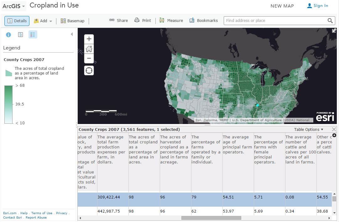
Cropland in Use Map of the USA in ArcGIS Online.
Labels
You must be a registered user to add a comment. If you've already registered, sign in. Otherwise, register and sign in.
About the Author
I believe that spatial thinking can transform education and society through the application of Geographic Information Systems for instruction, research, administration, and policy.
I hold 3 degrees in Geography, have served at NOAA, the US Census Bureau, and USGS as a cartographer and geographer, and teach a variety of F2F (Face to Face) (including T3G) and online courses. I have authored a variety of books and textbooks about the environment, STEM, GIS, and education. These include "Interpreting Our World", "Essentials of the Environment", "Tribal GIS", "The GIS Guide to Public Domain Data", "International Perspectives on Teaching and Learning with GIS In Secondary Education", "Spatial Mathematics" and others. I write for 2 blogs, 2 monthly podcasts, and a variety of journals, and have created over 5,000 videos on the Our Earth YouTube channel.
Yet, as time passes, the more I realize my own limitations and that this is a lifelong learning endeavor and thus I actively seek mentors and collaborators.
Labels
-
Administration
38 -
Announcements
44 -
Career & Tech Ed
1 -
Curriculum-Learning Resources
178 -
Education Facilities
24 -
Events
47 -
GeoInquiries
1 -
Higher Education
518 -
Informal Education
265 -
Licensing Best Practices
46 -
National Geographic MapMaker
10 -
Pedagogy and Education Theory
187 -
Schools (K - 12)
282 -
Schools (K-12)
184 -
Spatial data
24 -
STEM
3 -
Students - Higher Education
231 -
Students - K-12 Schools
85 -
Success Stories
22 -
TeacherDesk
1 -
Tech Tips
83
- « Previous
- Next »