Turn on suggestions
Auto-suggest helps you quickly narrow down your search results by suggesting possible matches as you type.
Cancel
- Home
- :
- All Communities
- :
- Industries
- :
- Education
- :
- Education Blog
- :
- Primary School Spatial Thinking and GIS Activities
Primary School Spatial Thinking and GIS Activities
Subscribe
1882
0
11-06-2014 11:00 PM
- Subscribe to RSS Feed
- Mark as New
- Mark as Read
- Bookmark
- Subscribe
- Printer Friendly Page
- Report Inappropriate Content
11-06-2014
11:00 PM
We receive many inquiries about how GIS and spatial thinking can be used with primary (elementary) aged students. In honor of GIS Day and Geography Awareness Week being upon us, I thought it would be the perfect time to highlight a few ideas and resources that you could use to develop and apply spatial thinking skills.
We have always advocated (1) that the most appropriate tool be used for the objective at hand; and (2) spatial thinking skills are developed through a variety of means, methods, settings, and media. These include the appropriate use of ArcGIS Online, for example, to examine world biomes, the locations and growth of cities, land use and demography of their local community, population change by country, the frequency and distribution of earthquakes and other natural hazards, the shape and size of watersheds, and so on. A selective use of the ArcGIS Online presentation mode, for example, to foster students as "map detectives" can be used effectively, as I have done with this "Name That Place" presentation and with another entitled "Weird Earth."
However, fostering spatial thinking at young ages in particular needs to use all five senses, and needs to include outdoor experiences. Using globes, mapping trees on campus, watching videos about scale coupled with measuring objects around school and the perimeter of the school building are just a few activities that can be effectively used. I am a firm believer in fostering spatial thinking using tactile-based activities such as this lesson I developed that asks students to create a thematic map on a translucent sheet of paper based on ArcGIS Online imagery, described here and in video form here. Another tried-and-true lesson is to ask students to draw a map of their classroom, and, depending on the students' age, incorporating map scale. Another simple but powerful activity I have used during hundreds of school visits over the past 20 years is to ask the students to draw an outline of the school building, as it would look from above, orienting it according to cardinal directions, and labeling the different sections of the building and school grounds. Then, I ask students to check their maps against the imagery in ArcGIS Online and discuss differences and similarities and the reasons for them.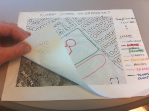
Our colleagues in education and industry continue to create a rich body of resources. For example, Barbaree Duke created a series of language-arts based activities, some of which can be used in primary school. The 20 Minute GIS for Young Explorers curriculum from GISetc spans multiple disciplines and though rich in content, each can truly be taught in 20 minutes.
Finally, exploring history, geography, art, science, mathematics, and other disciplines can be easily done through studying the gallery of storymaps or ... having the students make their own storymap. Other ideas exist on the GIS Day website. I've run out of space. What are your ideas for fostering spatial thinking at young ages?
We have always advocated (1) that the most appropriate tool be used for the objective at hand; and (2) spatial thinking skills are developed through a variety of means, methods, settings, and media. These include the appropriate use of ArcGIS Online, for example, to examine world biomes, the locations and growth of cities, land use and demography of their local community, population change by country, the frequency and distribution of earthquakes and other natural hazards, the shape and size of watersheds, and so on. A selective use of the ArcGIS Online presentation mode, for example, to foster students as "map detectives" can be used effectively, as I have done with this "Name That Place" presentation and with another entitled "Weird Earth."
However, fostering spatial thinking at young ages in particular needs to use all five senses, and needs to include outdoor experiences. Using globes, mapping trees on campus, watching videos about scale coupled with measuring objects around school and the perimeter of the school building are just a few activities that can be effectively used. I am a firm believer in fostering spatial thinking using tactile-based activities such as this lesson I developed that asks students to create a thematic map on a translucent sheet of paper based on ArcGIS Online imagery, described here and in video form here. Another tried-and-true lesson is to ask students to draw a map of their classroom, and, depending on the students' age, incorporating map scale. Another simple but powerful activity I have used during hundreds of school visits over the past 20 years is to ask the students to draw an outline of the school building, as it would look from above, orienting it according to cardinal directions, and labeling the different sections of the building and school grounds. Then, I ask students to check their maps against the imagery in ArcGIS Online and discuss differences and similarities and the reasons for them.

Creating a thematic map from a satellite image.
Our colleagues in education and industry continue to create a rich body of resources. For example, Barbaree Duke created a series of language-arts based activities, some of which can be used in primary school. The 20 Minute GIS for Young Explorers curriculum from GISetc spans multiple disciplines and though rich in content, each can truly be taught in 20 minutes.
Finally, exploring history, geography, art, science, mathematics, and other disciplines can be easily done through studying the gallery of storymaps or ... having the students make their own storymap. Other ideas exist on the GIS Day website. I've run out of space. What are your ideas for fostering spatial thinking at young ages?
Labels
You must be a registered user to add a comment. If you've already registered, sign in. Otherwise, register and sign in.
About the Author
I believe that spatial thinking can transform education and society through the application of Geographic Information Systems for instruction, research, administration, and policy.
I hold 3 degrees in Geography, have served at NOAA, the US Census Bureau, and USGS as a cartographer and geographer, and teach a variety of F2F (Face to Face) (including T3G) and online courses. I have authored a variety of books and textbooks about the environment, STEM, GIS, and education. These include "Interpreting Our World", "Essentials of the Environment", "Tribal GIS", "The GIS Guide to Public Domain Data", "International Perspectives on Teaching and Learning with GIS In Secondary Education", "Spatial Mathematics" and others. I write for 2 blogs, 2 monthly podcasts, and a variety of journals, and have created over 5,000 videos on the Our Earth YouTube channel.
Yet, as time passes, the more I realize my own limitations and that this is a lifelong learning endeavor and thus I actively seek mentors and collaborators.
Labels
-
Administration
38 -
Announcements
45 -
Career & Tech Ed
1 -
Curriculum-Learning Resources
179 -
Education Facilities
24 -
Events
47 -
GeoInquiries
1 -
Higher Education
519 -
Informal Education
266 -
Licensing Best Practices
46 -
National Geographic MapMaker
17 -
Pedagogy and Education Theory
187 -
Schools (K - 12)
282 -
Schools (K-12)
185 -
Spatial data
24 -
STEM
3 -
Students - Higher Education
231 -
Students - K-12 Schools
86 -
Success Stories
22 -
TeacherDesk
1 -
Tech Tips
83
- « Previous
- Next »