Turn on suggestions
Auto-suggest helps you quickly narrow down your search results by suggesting possible matches as you type.
Cancel
The 15 Minute Story Map
Subscribe
662
0
07-25-2013 11:00 PM
- Subscribe to RSS Feed
- Mark as New
- Mark as Read
- Bookmark
- Subscribe
- Printer Friendly Page
- Report Inappropriate Content
07-25-2013
11:00 PM
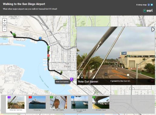
Can you build an Esri Story Map in 15 minutes? Yes! The map I created in that amount of time shows my walk from the San Diego Convention Center to the San Diego airport. I was in that wonderful city for the Esri Education GIS Conference and the Esri International User Conference. Walk? Yes, the San Diego airport is one of the few airports that you can actually walk to, and doable in just under an hour (I must admit I got a bit sweaty while wearing my map tie and dragging my luggage). I wanted to use that walking time to reflect upon all that I had learned at the conferences, enjoy the harbor views one last time before departing, and use it as a test case for creating a Story Map.
First, I turned on my smartphone and fired up RunKeeper, a fitness app. I took a few photos of the convention center and harbor along the way with that same phone. I emailed those photos to my Google Plus/Picasaweb account's public dropbox. Once at the airport gate, I saved my route as a GPX file, uploaded it to ArcGIS Online, and published my map as a Story Map web application. I pointed to the location of my photographs, added some captions, and I was done.
Since returning to the office, I have resisted the temptation to edit my map to make it look just a little bit nicer, because that would defeat my purpose. My purpose was to illustrate that (1) Esri Story Maps can be created to tell just about any conceivable type of story, and that (2) they can be quickly generated, even at a crowded airport gate! What story of your own can you make a map of using these techniques?

Walking to the San Diego Airport: Story Map.
First, I turned on my smartphone and fired up RunKeeper, a fitness app. I took a few photos of the convention center and harbor along the way with that same phone. I emailed those photos to my Google Plus/Picasaweb account's public dropbox. Once at the airport gate, I saved my route as a GPX file, uploaded it to ArcGIS Online, and published my map as a Story Map web application. I pointed to the location of my photographs, added some captions, and I was done.
Since returning to the office, I have resisted the temptation to edit my map to make it look just a little bit nicer, because that would defeat my purpose. My purpose was to illustrate that (1) Esri Story Maps can be created to tell just about any conceivable type of story, and that (2) they can be quickly generated, even at a crowded airport gate! What story of your own can you make a map of using these techniques?
You must be a registered user to add a comment. If you've already registered, sign in. Otherwise, register and sign in.
About the Author
I believe that spatial thinking can transform education and society through the application of Geographic Information Systems for instruction, research, administration, and policy.
I hold 3 degrees in Geography, have served at NOAA, the US Census Bureau, and USGS as a cartographer and geographer, and teach a variety of F2F (Face to Face) (including T3G) and online courses. I have authored a variety of books and textbooks about the environment, STEM, GIS, and education. These include "Interpreting Our World", "Essentials of the Environment", "Tribal GIS", "The GIS Guide to Public Domain Data", "International Perspectives on Teaching and Learning with GIS In Secondary Education", "Spatial Mathematics" and others. I write for 2 blogs, 2 monthly podcasts, and a variety of journals, and have created over 5,000 videos on the Our Earth YouTube channel.
Yet, as time passes, the more I realize my own limitations and that this is a lifelong learning endeavor and thus I actively seek mentors and collaborators.
Labels
-
Administration
38 -
Announcements
45 -
Career & Tech Ed
1 -
Curriculum-Learning Resources
179 -
Education Facilities
24 -
Events
47 -
GeoInquiries
1 -
Higher Education
519 -
Informal Education
266 -
Licensing Best Practices
46 -
National Geographic MapMaker
17 -
Pedagogy and Education Theory
187 -
Schools (K - 12)
282 -
Schools (K-12)
185 -
Spatial data
24 -
STEM
3 -
Students - Higher Education
231 -
Students - K-12 Schools
86 -
Success Stories
22 -
TeacherDesk
1 -
Tech Tips
83
- « Previous
- Next »